Bear Mountain Trail
State: NH |
The Bear Mountain Trail traversed Bear Mountain, connecting Bear Notch to the Bear Mountain - Table Mountain col.
|
|
| Bear Mountain Trail Details |
|
| Also Known As: |
|
|
| Location: |
White Mountains |
|
| Peak: |
Bear Mountain |
|
| Opened: |
1930s |
|
| Closed: |
1960 |
|
| Reason Closed: |
|
|
| Guidebook Descriptions: |
|
1940 AMC White Mountain Guide
Bear Mountain Trail (WMNF)
The entrance to this trail is from a short wood road which makes a loop on the E side of the Bear Notch Road a short distance S of the heigh-of-land. It follows the ridge of Bear Mtn. E and slightly S to its terminus in a col between Bear and Table Mtns. Where it meets Bear Brooks Trail. This point is also to the W terminus of Deer Brook Trail. At 1.5 m. Bear Mtn. Ski Trail leads N to the Bear Notch Road, and just beyond is a fine view of Bartlett Village and the Presidential Range. No water.
Distances. Bear Notch Road to summit of Bear Mtn. and Bear Mtn. Ski Trail 1 ½ m.; to terminus (junction with Bear Brooks Trail) 3 ¼ m.; to Rock Gorge Forest Camp (beyond terminus) 5 m.
1948 AMC White Mountain Guide
Bear Mountain Trail (WMNF)
This trail leaves the E side of Bear Notch Road near the height-of-land. It ascends the NW ridge of Bear Mtn., and after reaching the summit (3,230 ft.) descends generally E meeting the upper terminus of the Cilley Brook Trail in the col between Bear and Table Mtns. At this point the trail turns sharp L (N) and then shortly bears R (E) and passes close to but S of the summit of Table Mtn.
A little farther on the trail turns L (NE) and follows along a broad ridge and about ½ m. before reaching peak “2884” (see Chocorua map) the Reservoir Trail leaves L for Bartlett. About a mile farther the trail passes L of the summit of West Moat and ends at the Stony Brook Trail.
Distances. Bear Notch Road to summit of Bear Mountain 1 ½ m. (1 hr. 30 min.); Cilley Brook Trail 3 ¼ m. (2 hrs. 30 min.); Stony Brook Trail 7 m. (4 hrs. 15 min.).
1960 AMC White Mountain Guide
Bear Mountain Trail (WMNF)
With the opening of the WMNF Attitash Trail in 1960, this trail will be abandoned. A brief description follows.
The trail leaves the E side of Bear Notch Road near the height-of-land. It ascends the NW ridge of Bear Mtn., and after reaching the summit (3217 ft.) descends generally E, meeting the Attitash Trail (L) in the col between Bear and Table Mtns. About 3 ¼ m. |
|
| Images: |
|
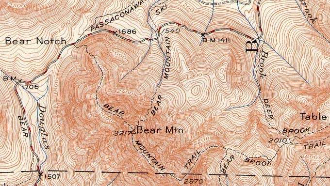
1950 USGS map of Bear Mountain
|
|
| Links: |
|
|
|
| Last updated 2012-12-18 |
| Disclaimer: Data provided for academic and historical purposes only. Respect all signs. |
