Home
States
Colorado
Connecticut
Maine
Massachusetts
New Hampshire
New York
Rhode Island
Utah
Vermont
View All
Lists
NE 4,000 Footers
NE 100 Highest
NH 4,000 Footers
NH 100 Highest
NH 52 With A View
NH Belknap Range
NH Ossipee 10
Links
Trail Conditions
Trip Log
Sunrises
Sunsets
About
|
Bald Pate Mountain
Bridgton, ME
Trailheads, measurements, times, distances, and maps are all approximate and relative to the hike(s) as shown below.
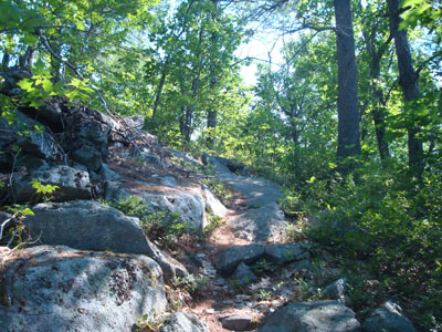
Looking up the Pate Trail
Route: Micah Trail, South Face Loop Trail, Pate Trail, (Bald Pate Mountain), Pate Trail, South Face Loop Trail, Micah Trail
My original plan had been to hike Bald Pate Mountain - in Grafton Notch. A poor weather forecast changed that plan, so I decided to check out another Bald Pate Mountain, a small one located near Bridgton.
Considering the area had its own web site, I figured the trailhead would be easy to find. Fortunately I had taken a photo of the map provided on the web site, so I was able to pull out my camera and see that the trailhead was located a bit uphill from the end of the road.
The hike didn't start out that well - as soon as I parked, I had a deer fly flying around my truck. As I walked through the field and into the woods, I had more and more of those annoying things orbiting my head at warp speed. I considered turning around, but only after one last trick - putting a fern in my hat. I grabbed a rather large one and stuck it on the back of my hat - this seemed to confuse the deer flies enough to keep them from flying into me as much (and a few seemed to give up).
Soon, the cliff of Bald Pate Mountain was visible down the trail - this reminded me of the trail that leads to Square Ledge (near Passaconaway).
At the first trail junction (marked with a cairn and wooden blazes), I took a left, then took a right shortly thereafter onto the signed Pate Trail. While the hike up to this point had been gentle, things changed big time - steep, rocky foot, and soon, views! The views from the top of the cliff were tremendous - I intend to return on a nicer day to check them out again.
The trail continued to ascend steeply after the cliff, soon arriving at the summit. After signing in on the log, I checked out a few viewpoints, ate a few blueberries, and headed back down.
Certainly a neat little peak!
| Hike Ratings |
|
Getting To Trailhead: |
Moderate |
| Destination: |
Bald Pate Mountain |
|
Length: |
Moderate |
|
Steepness: |
Difficult |
|
Navigation: |
Easy |
|
Views: |
Excellent |
|
Crowds: |
Minimal |
|
| Hike Stats |
|
Date Hiked: |
Sunday, July 13, 2008 |
| Hike Commenced: |
9:47 AM |
| Parking Elevation: |
640' |
| Destination: |
Bald Pate Mountain |
| Ascent Commenced: |
9:47 AM |
| Summit Reached: |
10:05 AM |
| Time Elapsed: |
00:18 |
| Trailhead Elevation: |
640' |
| Summit Elevation: |
1,150' |
| Vertical Gain: |
540' |
|
|
| Hike Ended: |
10:32 AM |
| Hike Time Elapsed: |
00:45 |
| Hike Vertical Gain: |
580' |
|

The Micah Trail trailhead

Black-eyed susans at the Micah Trail trailhead

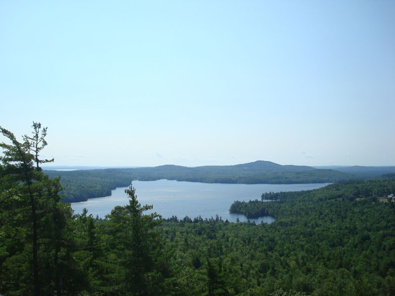
Looking southeast at Peabody Pond from the top of the cliff on Bald Pate Mountain


Directions to trailhead: Take Route 302 East from Bridgton, then take a right onto Route 117 South. Take a left onto Route 107 South. Shortly after passing through the village of South Bridgton, take a left onto Moose Cove Lodge Road. The trailhead and parking lot are located on the left at the edge of a small field, just before the road descends toward the entrance of Camp Micah.
Back to Bald Pate Mountain Profile
|