Home
States
Colorado
Connecticut
Maine
Massachusetts
New Hampshire
New York
Rhode Island
Utah
Vermont
View All
Lists
NE 4,000 Footers
NE 100 Highest
NH 4,000 Footers
NH 100 Highest
NH 52 With A View
NH Belknap Range
NH Ossipee 10
Links
Trail Conditions
Trip Log
Sunrises
Sunsets
About
|
Blueberry Mountain
Stow, ME, Stoneham, ME
Trailheads, measurements, times, distances, and maps are all approximate and relative to the hike(s) as shown below.

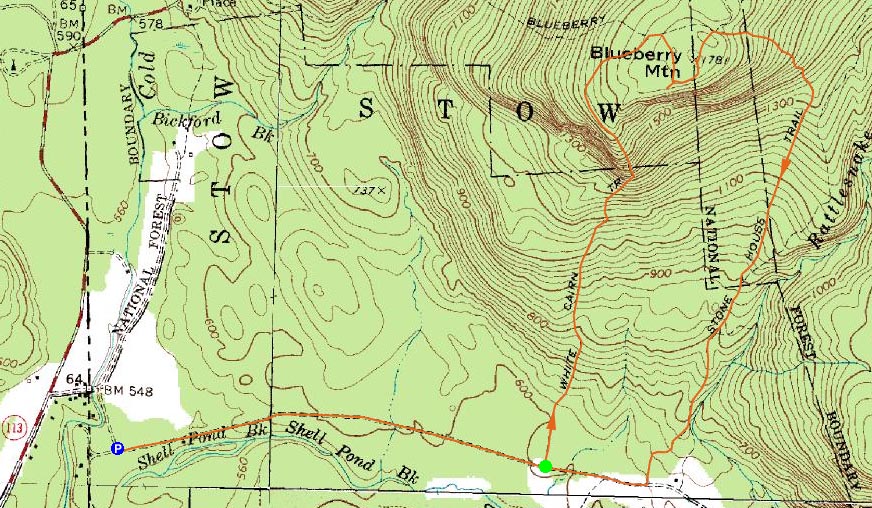
The Lookout Loop trail
Route: Stone House Road, White Cairn Trail, Blueberry Ridge Trail, Lookout Loop, (Blueberry Mountain), Lookout Loop, Blueberry Ridge Trail, Stone House Trail, Stone House Road
Looking for a southern facing peak without too high of a summit elevation, I decided to head over to Blueberry Mountain. While I was hoping to perhaps park at the gate on Stone House Road, I was a bit let down to see there were still snowbanks on the road shortly after crossing the bridge - the snowbanks were only a few feet apart, apparently from plowing for four wheelers. Thus, instead of a .3 mile road walk to the White Cairn Trail, I had a 1.1 mile trek.
The first part of the White Cairn Trail was a bit bland - open woods, not much snow, not much vegetation. After following the gradual trail for awhile, it suddenly picked up quite quickly - a steep staircase followed by some nice ledges. The upper ledges provided what would be the best views of the Baldfaces.
After passing that vista, the trail dropped down slightly prior to climbing to the Blueberry Ridge Trail. From here, things were nasty for a hundred or so feet - the footbed was filled with water and topped with snow. Wet posthole potential!
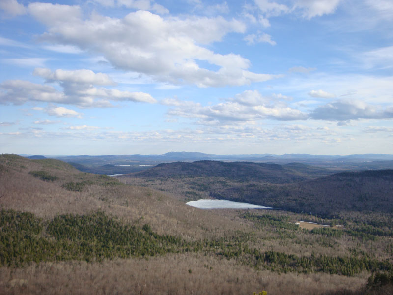
Soon thereafter, I reached the ledgy Lookout Loop trail. The main lookout on it provided beautiful views toward Pleasant Mountain, as well as eastern New Hampshire peaks.
Shortly after passing the ledges, I reached what I believe to be the highpoint on Blueberry Mountain - an elevated ledge of sorts, perhaps a dozen or so feet to the left of the trail.
For the descent, I chose the Stone House Trail. The first one to two tenths of a mile of the trail didn't get the memo that spring is here, as it had a whole bunch of snow on it still. Below that, however, was bare, mucky in spots, and frankly a bit boring. Skipping the Rattlesnake Pool since I was behind schedule, I did stop at the gorge - well worth the very short walk!
The road walk was a bit monotonous at the end of the day - this could be a nice loop, however, when the trailheads are a bit more accessible.
| Hike Ratings |
|
Getting To Trailhead: |
Moderate |
| Destination: |
Blueberry Mountain |
|
Length: |
Moderate |
|
Steepness: |
Difficult |
|
Navigation: |
Moderate |
|
Views: |
Excellent |
|
Crowds: |
Minimal |
|
| Hike Stats |
|
Date Hiked: |
Thursday, April 9, 2009 |
| Hike Commenced: |
4:13 PM |
| Parking Elevation: |
550' |
| Destination: |
Blueberry Mountain |
| Ascent Commenced: |
4:34 PM |
| Summit Reached: |
5:30 PM |
| Time Elapsed: |
00:56 |
| Trailhead Elevation: |
605' |
| Summit Elevation: |
1,781' |
| Vertical Gain: |
1,241' |
|
|
| Hike Ended: |
6:38 PM |
| Hike Time Elapsed: |
02:25 |
| Hike Vertical Gain: |
1,386' |
|

The White Cairn Trail trailhead

Looking at Shell Pond and Pleasant Mountain from near the summit of Blueberry Mountain


Directions to trailhead: Take Route 113 North from Fryeburg past the Baldface Loop parking lot. Take a right onto Stone House Road. In winter, one may be able to park on the side of the road, shortly after crossing the bridge, near the Leach Link trailhead. The White Cairn Trail trailhead is 1.1 miles down Stone House Road from the Leach Link trailhead, on the left.
Back to Blueberry Mountain Profile
|