Home
States
Colorado
Connecticut
Maine
Massachusetts
New Hampshire
New York
Rhode Island
Utah
Vermont
View All
Lists
NE 4,000 Footers
NE 100 Highest
NH 4,000 Footers
NH 100 Highest
NH 52 With A View
NH Belknap Range
NH Ossipee 10
Links
Trail Conditions
Trip Log
Sunrises
Sunsets
About
|
Burnt Meadow Mountain
Brownfield, ME
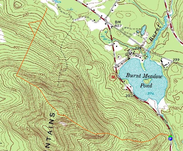
Trailheads, measurements, times, distances, and maps are all approximate and relative to the hike(s) as shown below.

Looking up the trail to Burnt Meadow Mountain
Route: Unknown trail, (Burnt Meadow Mountain), unknown snowmobile trail, various abandoned ski trails, unknown snowmobile trail, (Burnt Meadow Mountain), unknown trail
As a last minute decision, I decided to head over to Burnt Meadow Mountain to get some exercise and do some exploring. As I headed east, I was pleased to see some blue sky overhead - a nice change from the wet weather in nearly every other direction. I was also pleased to see that the parking lot was plowed - I had hoped to check this peak out last winter, however due to the excessive snows, plowing of the lot had stopped.
On snowshoes yet again, I was pleased to see the trail was broken out (albeit a bit messily if that's a word, which I doubt it is, but Notepad doesn't have a spell check and I don't feel like backspacing and typing this sentence correctly, so that's what the word will be, messily). As I ascended, I was very pleased to continue to see blue sky overhead, though the nearby clouds and sounds of wind were certainly threatening.
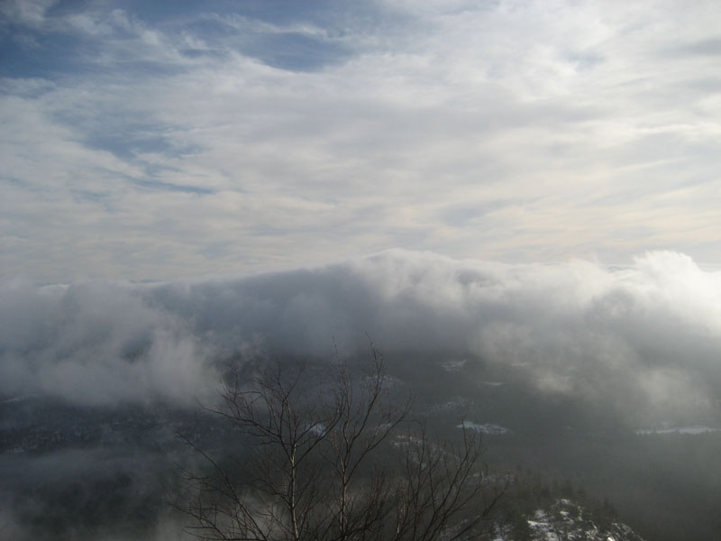
After climbing over the small subpeak and then ascending some of the steeps and ledges, I was soon at the foot of the final scramble. Since there wasn't much snow in this area, I took of my snowshoes and barebooted up to the summit. The views behind me as I did this were tremendous, as a bunch of different levels of clouds and fog made the horizon absolutely stunning - unfortunately, as I reached the summit, clouds overtook the mountain and prevented me from getting any shots other than one I took while climbing.
After waiting around for about five minutes in windy conditions for the clouds to move out, I decided to put my snowshoes back on and start exploring. At first, I followed a recently used snowmobile trail down the northeastern ridge. After dropping about 400 vertical feet, I was soon looking at the top terminal of the T-Bar lift for the defunct Zodiac Skiway (also known as Burnt Meadow Mountain Ski Area). After taking a bunch of photos of the terminal and upper towers, I followed an old set of ski tracks down the old lift line. While there wasn't much to see in terms of trails up high, some of the slopes were still somewhat visible as I approached the base area. After taking some photos of the bottom T-Bar terminal, former base lodge, and perhaps the footing of the former novice lift, I turned around and started to reascend, making one detour to check out some of the slopes.
After climbing all the way back up to the summit, I was a bit surprised to see how much the winds had picked up - me and my belongings were getting tossed around a bit! Fortunately, things were a bit better once I reached the consistent tree cover down low.
I'm surprised I haven't hiked this mountain more frequently - the trail is enjoyable and the views (when you have them) are great.
| Hike Ratings |
|
Getting To Trailhead: |
Moderate |
| Destination: |
Burnt Meadow Mountain |
|
Length: |
Moderate |
|
Steepness: |
Very Difficult |
|
Navigation: |
Easy |
|
Views: |
Excellent |
|
Crowds: |
Minimal |
|
| Hike Stats |
|
Date Hiked: |
Sunday, December 28, 2008 |
| Hike Commenced: |
8:43 AM |
| Parking Elevation: |
440' |
| Destination: |
Burnt Meadow Mountain |
| Ascent Commenced: |
8:43 AM |
| Summit Reached: |
9:30 AM |
| Time Elapsed: |
00:47 |
| Trailhead Elevation: |
440' |
| Summit Elevation: |
1,575' |
| Vertical Gain: |
1,258' |
|
|
| Hike Ended: |
11:58 AM |
| Hike Time Elapsed: |
03:15 |
| Hike Vertical Gain: |
2,506' |
|

The trailhead to Burnt Meadow Mountain on Route 160

Looking southeast from near the summit of Burnt Meadow Mountain


Directions to trailhead: Take 160 South from Brownfield. Shortly after passing the pond, just after a curve, there will be a small dirt parking lot on the right. The trailhead is to the right of this, marked with a light blue blaze.
Back to Burnt Meadow Mountain Profile
|