Home
States
Colorado
Connecticut
Maine
Massachusetts
New Hampshire
New York
Rhode Island
Utah
Vermont
View All
Lists
NE 4,000 Footers
NE 100 Highest
NH 4,000 Footers
NH 100 Highest
NH 52 With A View
NH Belknap Range
NH Ossipee 10
Links
Trail Conditions
Trip Log
Sunrises
Sunsets
About
|
East Royce Mountain
Batchelder's Grant, ME
Trailheads, measurements, times, distances, and maps are all approximate and relative to the hike(s) as shown below.

Looking up the Royce Trail
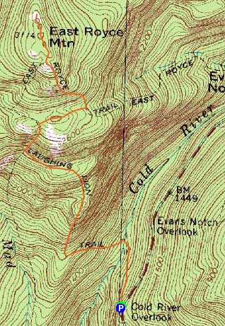
Route: Laughing Lion Trail, Royce Trail, Royce Connector, East Royce Trail, herd path, (East Royce Mountain), herd path, East Royce Trail, Royce Connector, Royce Trail, Laughing Lion Trail
In trying to explore the Evans Notch area more, I opted to check out another route to East Royce.
Parking off Route 113, I dropped gradually at first, then steeply to the Cold River crossing (more of a brook crossing). From there, the trail alternated between very steep and flat as it ascended to the Royce Trail. Once on the Royce Trail, the footing was terrible - rocks, roots, running water - slow going.
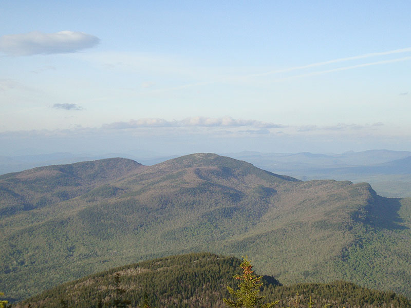
The footing improved upon reaching the Royce Connector. Dropping a decent amount of vertical, the trail reached the East Royce Trail. From there, it was a careful (some black ice), steep climb to the south ledges of East Royce. Continuing on the herd path over the summit, I soon reached the excellent north ledges, where I had views of the Baldfaces, Carters, Presidentials, Mahoosucs, and eastern Evans Notch peaks.
Running well behind schedule due to the footing at this point, I didn't linger too long (though I did get confused on my trek back to the trail, as I followed a wrong herd path briefly, missing a sharp left turn). Beyond there, it was a careful descent back to the trailhead, returning around sunset.
| Hike Ratings |
|
Getting To Trailhead: |
Easy |
| Destination: |
East Royce Mountain |
|
Length: |
Moderate |
|
Steepness: |
Difficult |
|
Navigation: |
Moderate |
|
Views: |
Excellent |
|
Crowds: |
Minimal |
|
| Hike Stats |
|
Date Hiked: |
Monday, May 10, 2010 |
| Hike Commenced: |
5:09 PM |
| Parking Elevation: |
1,370' |
| Destination: |
East Royce Mountain |
| Ascent Commenced: |
5:10 PM |
| Summit Reached: |
6:28 PM |
| Time Elapsed: |
01:18 |
| Trailhead Elevation: |
1,371' |
| Summit Elevation: |
3,114' |
| Vertical Gain: |
2,044' |
|
|
| Hike Ended: |
7:55 PM |
| Hike Time Elapsed: |
02:46 |
| Hike Vertical Gain: |
2,385' |
|

The Laughing Lion Trail trailhead

Wildflowers on the Laughing Lion Trail

The East Royce Trail

Looking at Caribou Mountain from the northern ledges of East Royce Mountain


Directions to trailhead: Take Route 113 North from Fryeburg, Maine. A few minutes after passing entering the National Forest and passing the Bickford House, the Cold River Outlook will be reached, with parking on either side of the road. The Laughing Lion Trail trailhead is just at the top of the curve, just after a highway gate, on the left.
Back to East Royce Mountain Profile
|