Home
States
Colorado
Connecticut
Maine
Massachusetts
New Hampshire
New York
Rhode Island
Utah
Vermont
View All
Lists
NE 4,000 Footers
NE 100 Highest
NH 4,000 Footers
NH 100 Highest
NH 52 With A View
NH Belknap Range
NH Ossipee 10
Links
Trail Conditions
Trip Log
Sunrises
Sunsets
About
|
Hawk Mountain
Waterford, ME
Trailheads, measurements, times, distances, and maps are all approximate and relative to the hike(s) as shown below.

Lookig down the Hawk Mountain Trail
Route: Hawk Mountain Trail, unknown road, bushwhack, (Hawk Mountain), bushwhack, Hawk Mountain Trail
After hiking Mt. Tire'm, my next stop was either Bear Mountain or Hawk Mountain. Since I couldn't seem to find any obvious trail to Hawk Mountain from the Hawk Mountain Road area, I continued up to the Hawk Mountain Trail trailhead.
The Hawk Mountain Trail is actually more of a rocky road, which appears to be open to use in the non-winter months. While the trail/road wasn't marked beyond the trailhead, it was fairly obvious to follow.
Approaching the height of land, I took a left at a quasi-fork so that I could find the true summit. After following the road a bit, I determined the approximate highpoint and bushwhacked to it. While there were no views here, a short bushwhack over to the Hawk Mountain Trail led to the near-summit ledges.
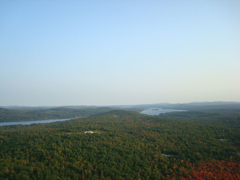
At a turn around area of the trail/road, there were nice views to the south. Fortunately, I kept looking around, as the trail continued to descend a bit - and led to a tremendous ledge area with great views to the south, east, and west. I suspect the views of the White Mountains would be excellent from here on a clear day (the haze made even Pleasant Mountain a bit blurry).
After taking in the views for a bit, I decided to call it a day and took the bland 'trail' back to the parking area.
| Hike Ratings |
|
Getting To Trailhead: |
Easy |
| Destination: |
Hawk Mountain |
|
Length: |
Easy |
|
Steepness: |
Easy |
|
Navigation: |
Easy |
|
Views: |
Excellent |
|
Crowds: |
Minimal |
|
| Hike Stats |
|
Date Hiked: |
Wednesday, September 24, 2008 |
| Hike Commenced: |
5:15 PM |
| Parking Elevation: |
922' |
| Destination: |
Hawk Mountain |
| Ascent Commenced: |
5:15 PM |
| Summit Reached: |
5:29 PM |
| Time Elapsed: |
00:14 |
| Trailhead Elevation: |
822' |
| Summit Elevation: |
1,061' |
| Vertical Gain: |
239' |
|
|
| Hike Ended: |
5:54 PM |
| Hike Time Elapsed: |
00:39 |
| Hike Vertical Gain: |
299' |
|

The Hawk Mountain Trail trailhead

Looking south from the Hawk Mountain vista at Crystal Pond and Long Lake


Directions to trailhead: Take Routes 35 and 37 north to South Waterford, then take a right onto Mill Hill Road. Shortly thereafter, take a right onto Hawk Mountain Road. Shortly after it becomes a dirt road, the Hawk Mountain Trail trailhead will be on the right and a parking area on the left.
Back to Hawk Mountain Profile
|