Home
States
Colorado
Connecticut
Maine
Massachusetts
New Hampshire
New York
Rhode Island
Utah
Vermont
View All
Lists
NE 4,000 Footers
NE 100 Highest
NH 4,000 Footers
NH 100 Highest
NH 52 With A View
NH Belknap Range
NH Ossipee 10
Links
Trail Conditions
Trip Log
Sunrises
Sunsets
About
|
Stony Ledge
Williamstown, MA
Trailheads, measurements, times, distances, and maps are all approximate and relative to the hike(s) as shown below.

Sperry Road to Stony Ledge
Today was the day for the Hopper, sort of. I have hiked the northern, eastern, and southern faces of Mt. Greylock, leaving west as the last one. After having read that the Hopper Trail was broken out up to Sperry Road as of Sunday, (thank you Views From The Top Trail Conditions!), I rolled the dice and gave it a try.
The beginning of the Hopper Trail is flat as it weaves through some fields. As it pulls away from the Hopper Brook, things steepen up quickly. With the leaves down, the views of this neat bowl are amazing.
Upon reaching Sperry Road, we witnessed a pack of three snowmobilers going nearly 100 miles per hour, no joke. We continued up the Hopper Trail/Sperry Road merger until we reached the junction where the Hopper Trail breaks off to the east. Seeing that this hadn't been broken and that following Sperry Road to Rockwell Road would add on a decent block of time (and risk with these speed demons on snowmobiles), we turned around and went up to Stony Ledge for lunch, stepping off the trail at one point so that the three sledders (with barely any control of their sleds) could fly by again.
While the at trailhead skies were mostly cloudy, it was quickly turning into a bluebird day at Stony Ledge with views reaching well into Vermont.
We then descended down a broken out Haley Farm Trail back to the Hopper Trail and to the parking lot.
This was my first time snowshoeing with poles this season; I was amazed how much easier it is to descend down steep hills with them.
| Hike Ratings |
|
Getting To Trailhead: |
Easy |
| Destination: |
Stony Ledge |
|
Length: |
Moderate |
|
Steepness: |
Difficult |
|
Navigation: |
Easy |
|
Views: |
Excellent |
|
Crowds: |
Minimal |
|
| Hike Stats |
|
Date Hiked: |
Tuesday, March 20, 2007 |
| Hike Commenced: |
12:34 PM |
| Parking Elevation: |
1,100' |
| Destination: |
Stony Ledge |
| Ascent Commenced: |
12:37 PM |
| Summit Reached: |
2:41 PM |
| Trailhead Elevation: |
1,105' |
| Summit Elevation: |
2,560' |
| Vertical Gain: |
1,555' |
| Hike Ended: |
4:06 PM |
| Hike Vertical Gain: |
1,635' |
|

Hopper Trail trailhead
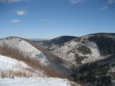
Looking north northeast at Mt. Prospect, Mt. Williams, and Mt. Fitch from Stony Ledge


Directions to trailhead: Take Route 2 to Route 43. Hopper Road will be on the left, and then will bear left at the Potter Road intersection. Parking available at the end of Hopper Road.
Back to Stony Ledge Profile
|

