Home
States
Colorado
Connecticut
Maine
Massachusetts
New Hampshire
New York
Rhode Island
Utah
Vermont
View All
Lists
NE 4,000 Footers
NE 100 Highest
NH 4,000 Footers
NH 100 Highest
NH 52 With A View
NH Belknap Range
NH Ossipee 10
Links
Trail Conditions
Trip Log
Sunrises
Sunsets
About
|
Black Mountain
Haverhill, NH, Benton, NH
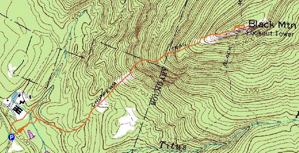
Trailheads, measurements, times, distances, and maps are all approximate and relative to the hike(s) as shown below.

Looking up the flatter portion of the Chippewa Trail
Route: Chippewa Trail, (Black Mountain), Chippewa Trail, unknown logging roads, Lime Kiln, unknown logging roads
I had been interested in hiking Black Mountain ever since seeing it from South Kinsman Mountain a few months earlier. Thus, on a nice lazy Saturday day, I had my destination.
The Chippewa Trail drops almost immediately into a wet gully - flooded badly by beavers. The first pond is crossed by a huge log...the second one, not as easily (sticks, I had to do a Kerri Strug balancing act on one foot to hop across).
After passing this mess, the trail follows an old logging road, which climbs at a very gradual pace past an old foundation. Shortly after that, the trail heads into the woods for a sustained steep section. At the end of this section is the first of many view ledges.
The trail climbs a bit more gradually after this, with some ledge walking, views aplenty. Soon, it merges with the Black Mountain Trail and makes its final ascent to the summit ledges.
The views from these ledges are excellent - a front row seat for Mt. Moosilauke and a great view of the Kinsmans with Franconia Ridge popping up behind them. There is also a potential for great views into Vermont, however there was a haze of sorts preventing it from being as good as I imagine it would be.
I met up with a few hikers at the top who told me about an old Lime Kiln near the bottom. I took their advice and checked this out - it's easy accessed by going straight where the Chippewa Trail otherwise turns to enter Beaverland. An old logging road heads up the west side of a brook. The kiln is a bit larger than two stories in height and is quite a sight in the middle of the woods.
After checking this out, I decided to go straight across the field, rather than head back to Beaverland. This proved to be a much easier route, as the logging road climbed back up a few hundred feet past the Chippewa Trail trailhead.
| Hike Ratings |
|
Getting To Trailhead: |
Easy |
| Destination: |
Black Mountain |
|
Length: |
Moderate |
|
Steepness: |
Difficult |
|
Navigation: |
Easy |
|
Views: |
Excellent |
|
Crowds: |
Minimal |
|
| Hike Stats |
|
Date Hiked: |
November 10, 2007 |
| Hike Commenced: |
11:57 AM |
| Parking Elevation: |
1,320' |
| Destination: |
Black Mountain |
| Ascent Commenced: |
11:57 AM |
| Summit Reached: |
12:51 PM |
| Time Elapsed: |
00:54 |
| Trailhead Elevation: |
1,320' |
| Summit Elevation: |
2,830' |
| Distance: |
1.9 miles |
| Vertical Gain: |
1,600' |
|
|
| Hike Ended: |
2:22 PM |
| Hike Time Elapsed: |
02:25 |
| Hike Vertical Gain: |
1,705' |
|

The Chippewa Trail trailhead on Lime Kiln Road

Looking southwest at Mt. Moosilauke from the Black Mountain summit


Directions to trailhead: Take Route 25 West from I-93 for quite some time, then take a right onto Lime Kiln Road. Head down this road, bearing left at a fork in the road, thus staying on Lime Kiln Road. The small parking area and trail head are on the right during a somewhat sharp turn.
Back to Black Mountain Profile
|