Home
States
Colorado
Connecticut
Maine
Massachusetts
New Hampshire
New York
Rhode Island
Utah
Vermont
View All
Lists
NE 4,000 Footers
NE 100 Highest
NH 4,000 Footers
NH 100 Highest
NH 52 With A View
NH Belknap Range
NH Ossipee 10
Links
Trail Conditions
Trip Log
Sunrises
Sunsets
About
|
Burleigh Mountain
New Hampton, NH
Trailheads, measurements, times, distances, and maps are all approximate and relative to the hike(s) as shown below.
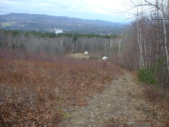
Looking down the hiking trail, prior to entering the woods
Route: Burleigh Mountain Trail
Having seen this mountain from I-93 for years, I decided to check it out. After parking at the beginning of Burleigh Mountain Road, I jogged up the road to the old ski area access road. Once reaching the base of the old ski area, I jogged up the somewhat steep hiking trail to the top of the recleared slope. Though cloudy on this day, the viewpoint at the top of the slope looked to offer nice views to the north.
Continuing into the woods on the trail (and now hiking instead of jogging), switchbacks helped reduce the steepness a bit. Reaching a col, I continued to the left to the highpoint of Burleigh Mountain. Though ledgy, the surrounding trees obscured any views. A few short bushwhacks were unsuccessful in finding any views.
For the descent, I headed back down the trail and checked out some old ski area remnants along the way.
| Hike Ratings |
|
Getting To Trailhead: |
Easy |
| Destination: |
Burleigh Mountain |
|
Length: |
Easy |
|
Steepness: |
Difficult |
|
Navigation: |
Easy |
|
Views: |
Excellent |
|
Crowds: |
Moderate |
|
| Hike Stats |
|
Date Hiked: |
Friday, December 3, 2010 |
| Hike Commenced: |
3:20 PM |
| Parking Elevation: |
897' |
| Destination: |
Burleigh Mountain |
| Ascent Commenced: |
3:26 PM |
| Summit Reached: |
3:37 PM |
| Time Elapsed: |
00:11 |
| Trailhead Elevation: |
970' |
| Summit Elevation: |
1,462' |
| Vertical Gain: |
502' |
|
|
| Hike Ended: |
4:13 PM |
| Hike Time Elapsed: |
00:53 |
| Hike Vertical Gain: |
585' |
|
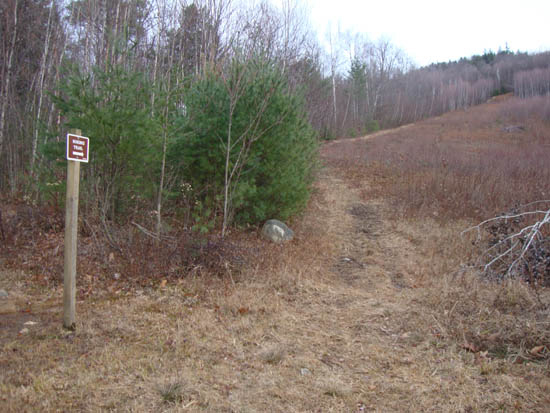
The Burleigh Mountain hiking trail

Looking through the trees at Hersey Mountain from Burleigh Mountain
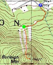

Directions to trailhead: From I-93 in New Hampton, take Route 104 West. Take a left onto Route 132. Shortly after passing through New Hampton, take a right onto Gordon Hill Road. After heading up this road briefly, it reaches a T-intersection with Burleigh Mountain Road (on left). There is limited room to park at the junction. Continue on foot up Burleigh Mountain Road, then take a right near the end onto a gated road. The Burleigh Mountain hiking trail will be near the end of this road, on the left at a somewhat clear ski slope.
Back to Burleigh Mountain Profile
|

