Home
States
Colorado
Connecticut
Maine
Massachusetts
New Hampshire
New York
Rhode Island
Utah
Vermont
View All
Lists
NE 4,000 Footers
NE 100 Highest
NH 4,000 Footers
NH 100 Highest
NH 52 With A View
NH Belknap Range
NH Ossipee 10
Links
Trail Conditions
Trip Log
Sunrises
Sunsets
About
|
The Captain, Mt. Carrigain
Livermore, NH
Trailheads, measurements, times, distances, and maps are all approximate and relative to the hike(s) as shown below.

Signal Ridge
Route: Sawyer River Road, Signal Ridge Trail, bushwhack, (The Captain), bushwhack, Signal Ridge Trail, (Mt. Carrigain), Signal Ridge Trail, Sawyer River Road
Sawyer River Road was well packed for snowmobile traffic.
Signal Ridge Trail flats were well packed for snowshoe traffic. Barebooters were still sinking a bit judging by tracks. Nearing the ridge, there was drifting this morning.
Shortly after passing the spring on Carrigain proper, we slabbed around to the spine of the ridge (ie wilderness boundary) and descended it to the Captain col. Thanks in part to the snowpack, it was generally pretty good going with only a few very brief scrappy areas. Also quite steep, but no visible cliff bands. Snowpack probably 3-4 feet.
Ascent up the Captain proper (between the cliff bands) was slow going, as it was a bit scrappier, and because with the steeps, the snow was belt high for breaking. Fortunately we ended up hitting the recognized highpoint directly. The snowpack around the summit plateau was adequate enough that we were able to go over to the other potential highpoint without too much of an issue (a bit thicker in summer).
Returning to the col, we ascended a little bit, then dropped down to Carrigain Pond, surprisingly in open woods the whole way, contrary to the horror stories I had read about. Scrubby on the east side, cliffy on the north, but the east-northeast side of it was smooth sailing. Very neat place.
Climb back up Carrigain was slow going due to the powder, but the relatively mild temperatures were appreciated. Did the extra hundred or so vertical feet up to the fire tower to get the views, then headed out on the well packed trail.
Overall, it clocked in at about 11 hours (roughly half of it off trail with generous breaks for the views) and about 16.2 miles.
| Hike Ratings |
|
Getting To Trailhead: |
Difficult |
| Destination: |
The Captain |
|
Length: |
Very Difficult |
|
Steepness: |
Very Difficult |
|
Navigation: |
Very Difficult |
|
Views: |
Excellent |
|
Crowds: |
Minimal |
| Destination: |
Mt. Carrigain |
|
Length: |
Very Difficult |
|
Steepness: |
Very Difficult |
|
Navigation: |
Very Difficult |
|
Views: |
Excellent |
|
Crowds: |
Minimal |
|
| Hike Stats |
|
Date Hiked: |
Saturday, February 28, 2015 |
| Parking Elevation: |
900' |
| Time To Trailhead: |
00:38 |
| Destination: |
The Captain |
| Time Elapsed: |
04:42 |
| Trailhead Elevation: |
1,370' |
| Summit Elevation: |
3,540' |
| Vertical Gain: |
3,580' |
| Destination: |
Mt. Carrigain |
| Time Elapsed: |
02:06 |
| Trailhead Elevation: |
3,540' |
| Summit Elevation: |
4,700' |
| Vertical Gain: |
1,520' |
|
|
| Hike Time Elapsed: |
10:52 |
| Hike Vertical Gain: |
5,590' |
|

Signal Ridge Trail trailhead on Sawyer River Road

The Captain as seen from Signal Ridge

The Captain as seen from the col

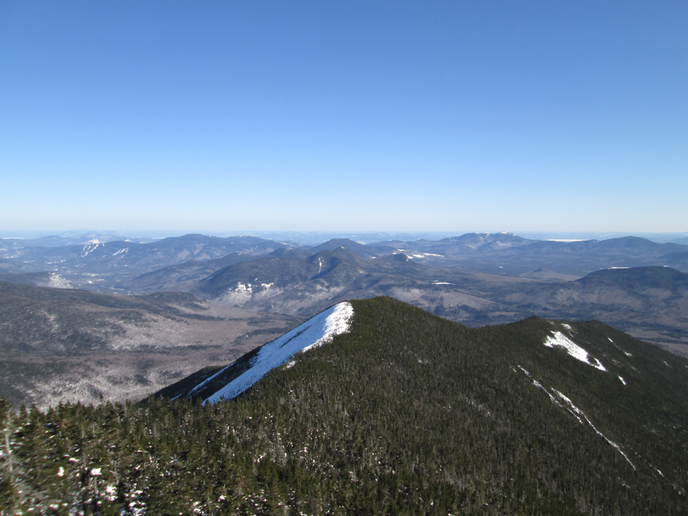
Looking at the Bonds from the Captain

Carrigain Pond

The Captain from Carrigain Pond

Mt. Carrigain from Carrigain Pond

Signal Ridge as seen from the Mt. Carrigain observation tower


Directions to trailhead: Take Route 302 West from Bartlett to Sawyer River Road. In winter, there is a WMNF fee parking lot located to the left of the closed Sawyer River Road. The Signal Ridge Trail is 2 miles up Sawyer River Road, on the right.
Back to The Captain Profile
Back to Mt. Carrigain Profile
|