Home
States
Colorado
Connecticut
Maine
Massachusetts
New Hampshire
New York
Rhode Island
Utah
Vermont
View All
Lists
NE 4,000 Footers
NE 100 Highest
NH 4,000 Footers
NH 100 Highest
NH 52 With A View
NH Belknap Range
NH Ossipee 10
Links
Trail Conditions
Trip Log
Sunrises
Sunsets
About
|
Hedgehog Mountain
Albany, NH
Trailheads, measurements, times, distances, and maps are all approximate and relative to the hike(s) as shown below.

Looking down the straight reroute of the UNH Trail to the parking area
Route: UNH Trail
The next stop in the rehab bandwagon was something around 1,200-1,500 vertical feet and about 5 miles long. Finally, after planning to hike it for a few months, it was time for Hedgehog Mountain.
The UNH Trail starts in a parking area just off Route 112. It starts off pretty much completely flat for almost a quarter of a mile. At the junction where the UNH Trail splits into a loop, I decided for the shorter leg for the ascent.
The trail continues at an easy pitch before steepening briefly near a lookout. From there, it continues at a mild pace before steepening again a bit before the summit.
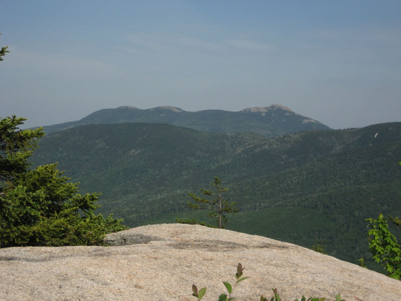
The natural views from the summit are nice, looking into the valley separating Hedgehog from Chocorua, Paugus, Passaconaway, and the Tripyramids.
The descent down the longer part of the loop was a bit more challenging, as there are some short steep sections and a few rocky areas. Nothing too bad, however. There are also nice views from the eastern lookout.
The trail is pretty easy to follow, however it's definitely overdue for some new blazes.
With the patella strap, the descent seemed to go fairly well - only minimal pain. I hope this continues to be true!
| Hike Ratings |
|
Getting To Trailhead: |
Easy |
| Destination: |
Hedgehog Mountain |
|
Length: |
Moderate |
|
Steepness: |
Moderate |
|
Navigation: |
Moderate |
|
Views: |
Excellent |
|
Crowds: |
Minimal |
|
| Hike Stats |
|
Date Hiked: |
Monday, June 18, 2007 |
| Hike Commenced: |
4:00 PM |
| Parking Elevation: |
1,265' |
| Destination: |
Hedgehog Mountain |
| Ascent Commenced: |
4:01 PM |
| Summit Reached: |
4:45 PM |
| Time Elapsed: |
00:44 |
| Trailhead Elevation: |
1,270' |
| Summit Elevation: |
2,532' |
| Distance: |
1.9 miles |
| Vertical Gain: |
1,302' |
|
|
| Hike Ended: |
6:16 PM |
| Hike Time Elapsed: |
02:16 |
| Hike Distance: |
4.8 miles |
| Hike Vertical Gain: |
1,537' |
|

UNH Trail trailhead

Looking west at the Three Sisters and Mt. Chocorua from the Hedgehog Mountain summit


Directions to trailhead: Take Route 112 West from Conway. A bit after Bear Notch Road, look for the sign for the entrance to the UNH Trail (amongst others) Parking on the left. WMNF fee parking area.
Back to Hedgehog Mountain Profile
|