Home
States
Colorado
Connecticut
Maine
Massachusetts
New Hampshire
New York
Rhode Island
Utah
Vermont
View All
Lists
NE 4,000 Footers
NE 100 Highest
NH 4,000 Footers
NH 100 Highest
NH 52 With A View
NH Belknap Range
NH Ossipee 10
Links
Trail Conditions
Trip Log
Sunrises
Sunsets
About
|
Kinsman Mountain (North Peak), Kinsman Mountain (South Peak)
Lincoln, NH
Trailheads, measurements, times, distances, and maps are all approximate and relative to the hike(s) as shown below.
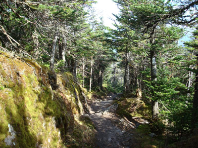
The Kinsman Ridge Trail near the Kinsman Mountain North Peak summit
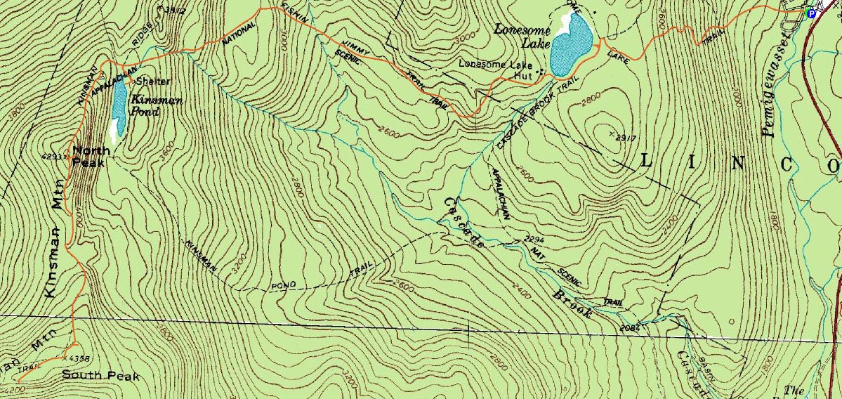
Route: Lonesome Lake Trail, Cascade Brook Trail, Fishin' Jimmy Trail, Kinsman Ridge Trail, (North Kinsman Mountain), Kinsman Ridge Trail, (South Kinsman Mountain), Kinsman Ridge Trail, Kinsman Pond Trail, (Kinsman Shelter), Kinsman Pond Trail, Fishin' Jimmy Trail, Cascade Brook Trail, Lonesome Lake Trail
With some time off from work and temperatures forecasted to enter into the 80s, I decided an earlier morning hike would be a good idea. Since it was midweek, it seemed logical to do the Kinsmans - thus avoiding them on a busy weekend.
Starting just before 7 AM, I think I was the first person to ascend - I would not see anyone until after leaving South Kinsman. The sun was just starting to hit Lonesome Lake when I arrived there - making for a really nice, peaceful scene. Up until this point, the trail is moderately steep with decent footing.
I then picked up the Fishin' Jimmy Trail on the hut side of the lake, continuing on it as it dips into a valley before doing two steep ascents up to the Kinsman Pond area - some parts of the steeps actually had wooden steps embedded in the ledge like the Beaver Brook Trail.
Now on the Kinsman Ridge Trail, things became progressively steeper as the North Kinsman summit neared - nothing too bad, but a minor scramble or two.
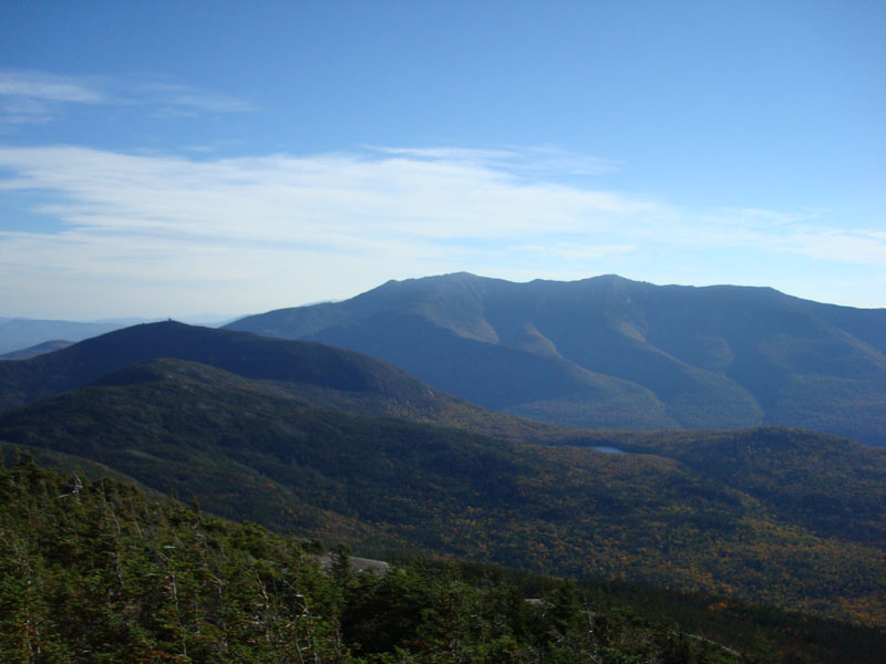
Arriving at the summit, I quickly descended to the first view ledge, and then down to the more scenic lower ledge - excellent views of Cannon Mountain, Lonesome Lake, Kinsman Pond, and the Franconia Ridge.
Next up was South Kinsman - it's a steep initial descent, followed by some flats and a slightly more gradual ascent to a false summit, then a dip before the south summit cairn.
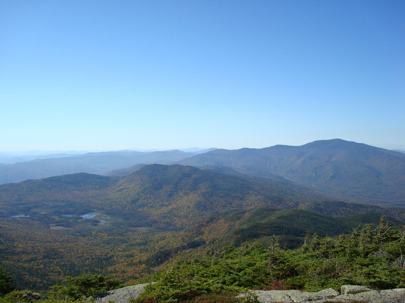
Though the growth at the summit is stunted, the views at the cairn are obstructed a bit (one can see the upper portions of the surrounding ridges). As a result, I decided to continue down the Kinsman Ridge Trail a bit to a really nice view ledge - excellent views of Moosilauke and points south and into Vermont.
After snapping a few shots and checking out other potential but lesser view points, I headed back to North Kinsman for an early lunch and a work call. Talk about telecommuting!
In contrast to the quiet ascent, the descent was gradually busier - a few folks were hanging around the nearly complete Kinsman Shelter, a few more on the Fishin' Jimmy Trail, and yet some more ascending the Lonesome Lake Trail.
All in all a nice day - between rain and obligations, it might be awhile before I hit the trails again, so it was good to get out for a few hours during the work week.
| Hike Ratings |
|
Getting To Trailhead: |
Easy |
| Destination: |
Kinsman Mountain (North Peak) |
|
Length: |
Moderate |
|
Steepness: |
Very Difficult |
|
Navigation: |
Easy |
|
Views: |
Excellent |
|
Crowds: |
Minimal |
| Destination: |
Kinsman Mountain (South Peak) |
|
Length: |
Moderate |
|
Steepness: |
Difficult |
|
Navigation: |
Easy |
|
Views: |
Excellent |
|
Crowds: |
Minimal |
|
| Hike Stats |
|
Date Hiked: |
Tuesday, September 25, 2007 |
| Hike Commenced: |
6:55 AM |
| Parking Elevation: |
1,750' |
| Destination: |
Kinsman Mountain (North Peak) |
| Ascent Commenced: |
6:55 AM |
| Summit Reached: |
8:57 AM |
| Time Elapsed: |
02:02 |
| Trailhead Elevation: |
1,750' |
| Summit Elevation: |
4,293' |
| Vertical Gain: |
2,738' |
| Destination: |
Kinsman Mountain (South Peak) |
| Ascent Commenced: |
9:05 AM |
| Summit Reached: |
9:35 AM |
| Time Elapsed: |
00:30 |
| Trailhead Elevation: |
4,293' |
| Summit Elevation: |
4,358' |
| Vertical Gain: |
373' |
|
|
| Hike Ended: |
12:37 PM |
| Hike Time Elapsed: |
05:42 |
| Hike Vertical Gain: |
3,436' |
|

The Lonesome Lake Trail trailhead at the Lafayette Campground hiker parking lot
Looking at Cannon Mountain and the Franconia Ridge from Kinsman Mountain's North Peak

The Kinsman Ridge Trail near the Kinsman Mountain South Peak summit

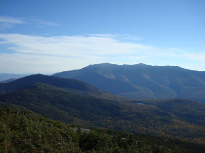
Looking at Mt. Moosilauke from Kinsman Mountain's South Peak


Directions to trailhead: Take I-93 South to the Lafayette Place exit. The Lonesome Lake Trail starts on the foot bridge at the hiker parking lot.
Back to Kinsman Mountain (North Peak) Profile
Back to Kinsman Mountain (South Peak) Profile
|