Home
States
Colorado
Connecticut
Maine
Massachusetts
New Hampshire
New York
Rhode Island
Utah
Vermont
View All
Lists
NE 4,000 Footers
NE 100 Highest
NH 4,000 Footers
NH 100 Highest
NH 52 With A View
NH Belknap Range
NH Ossipee 10
Links
Trail Conditions
Trip Log
Sunrises
Sunsets
About
|
Kinsman Mountain (North Peak), Kinsman Mountain (South Peak)
Lincoln, NH, Franconia, NH
Trailheads, measurements, times, distances, and maps are all approximate and relative to the hike(s) as shown below.

Looking back across Lonesome Lake on the way to North Kinsman
Route: Lonesome Lake Trail, Lonesome Lake, Fishin' Jimmy Trail, Kinsman Ridge Trail, (North Kinsman), Kinsman Ridge Trail, (South Kinsman), Kinsman Ridge Trail, (North Kinsman Trail), Kinsman Ridge Trail, Fishin' Jimmy Trail, Lonesome Lake, Lonesome Lake Trail
With a chilly, but nice afternoon forecasted, I took a few hours off and headed up to the Kinsmans. Having never hiked the Kinsmans via the east in winter, I decided to give the Fishin' Jimmy Trail another trail.
The Lonesome Lake Trail was packed like a sidewalk, making for smooth sailing. Reaching the lake, I cut directly across on the snowcovered ice, passed the hut, and hopped onto the Fishin' Jimmy Trail.
With a nice snowshoe track on it, it was fairly smooth sailing, though the pointless-ups-and-downs of the trail, as well as a few iced over ledges, slowed progress a little. Nonetheless, I found the trail to be much more scenic than in the summer.
Reaching Kinsman Ridge, the temperatures were likely zero or below. Upon reaching North Kinsman, there were strong views from the near summit ledge. Continuing to South Kinsman, there were again excellent views, however the somewhat open nature of the summit, combined with freezing, slight wind gusts stopped me from lingering for too long.
As I decided the Fishin' Jimmy Trail, I noticed what seemed to be flu like symptoms coming on pretty quickly. The body aches and fatigue made the ups and downs much less than appreciated. Nonetheless, I was able to make it out before sunset, and before the flu would knock me over that night.
| Hike Ratings |
|
Getting To Trailhead: |
Easy |
| Destination: |
Kinsman Mountain (North Peak) |
|
Length: |
Moderate |
|
Steepness: |
Difficult |
|
Navigation: |
Moderate |
|
Views: |
Excellent |
|
Crowds: |
Minimal |
| Destination: |
Kinsman Mountain (South Peak) |
|
Length: |
Moderate |
|
Steepness: |
Difficult |
|
Navigation: |
Easy |
|
Views: |
Excellent |
|
Crowds: |
Minimal |
|
| Hike Stats |
|
Date Hiked: |
Monday, January 31, 2011 |
| Hike Commenced: |
11:54 AM |
| Parking Elevation: |
1,750' |
| Destination: |
Kinsman Mountain (North Peak) |
| Ascent Commenced: |
11:59 AM |
| Summit Reached: |
2:00 PM |
| Time Elapsed: |
02:01 |
| Trailhead Elevation: |
1,780' |
| Summit Elevation: |
4,293' |
| Vertical Gain: |
2,708' |
| Destination: |
Kinsman Mountain (South Peak) |
| Ascent Commenced: |
2:02 PM |
| Summit Reached: |
2:29 PM |
| Time Elapsed: |
00:27 |
| Trailhead Elevation: |
4,293' |
| Summit Elevation: |
4,358' |
| Distance: |
.9 mile |
| Vertical Gain: |
373' |
| Destination: |
Kinsman Mountain (North Peak) |
| Ascent Commenced: |
2:32 PM |
| Summit Reached: |
3:00 PM |
| Time Elapsed: |
00:28 |
| Trailhead Elevation: |
4,358' |
| Summit Elevation: |
4,293' |
| Distance: |
.9 mile |
| Vertical Gain: |
308' |
|
|
| Hike Ended: |
4:45 PM |
| Hike Time Elapsed: |
4:51 |
| Hike Vertical Gain: |
3,614' |
|

The Lonesome Lake Trail trailhead in the Lafayette Place campground

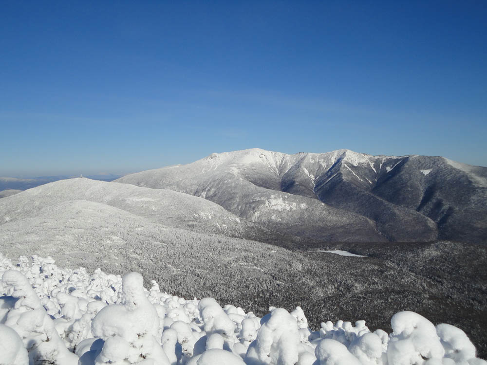
Cannon Mountain and the Franconia Ridge as seen from the North Kinsman vista

The Kinsman Ridge Trail between the Kinsmans

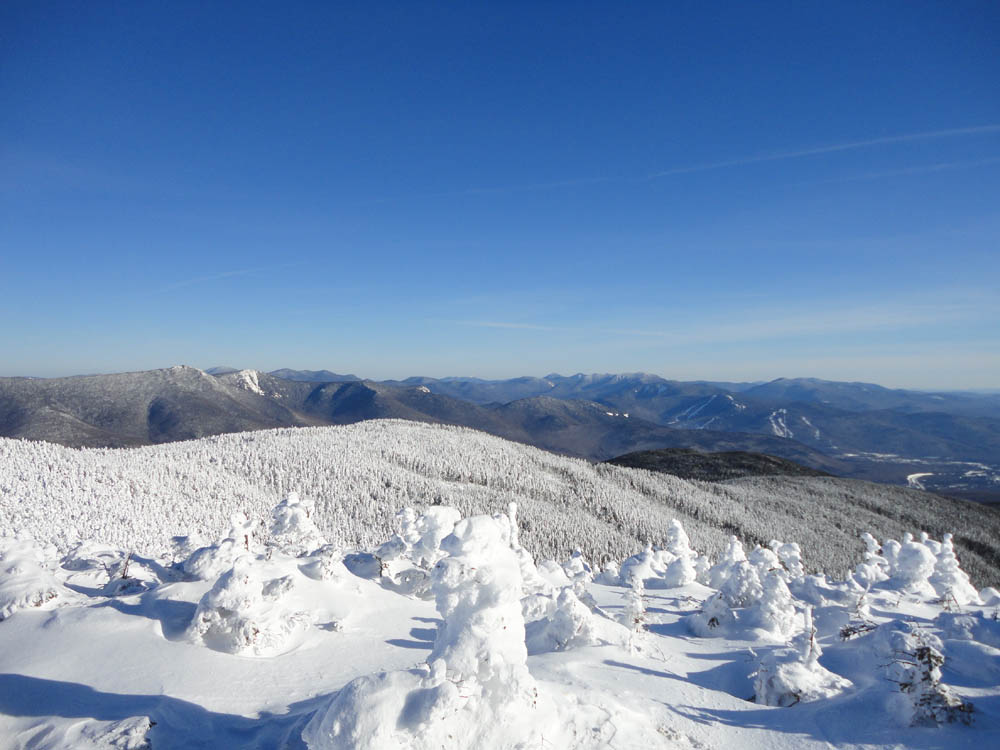
The southern Franconias, Lincoln, and points south as seen from South Kinsman


Directions to trailhead: Take I-93 South to the Lafayette Place exit. In winter, plowed parking is available to the right. From there, one can cross the brook/river on a bridge and head across the campground to the Lonesome Lake Trail trailhead, which is just beyond the (seasonally closed) restroom building.
Back to Kinsman Mountain (North Peak) Profile
Back to Kinsman Mountain (South Peak) Profile
|