Home
States
Colorado
Connecticut
Maine
Massachusetts
New Hampshire
New York
Rhode Island
Utah
Vermont
View All
Lists
NE 4,000 Footers
NE 100 Highest
NH 4,000 Footers
NH 100 Highest
NH 52 With A View
NH Belknap Range
NH Ossipee 10
Links
Trail Conditions
Trip Log
Sunrises
Sunsets
About
|
West Bond, Mt. Bond, Bondcliff
Lincoln, NH
Trailheads, measurements, times, distances, and maps are all approximate and relative to the hike(s) as shown below.

Looking up the V Guitar Slide on West Bond
Route: Lincoln Woods Trail, Franconia Brook Trail, bushwhack, West Bond Spur, Bondcliff Trail, Lincoln Woods Trail
Trails were generally dry. Hellgate valley already seems past peak in terms of foliage...brownish yellows. Some isolated color in other valleys.
Took Lincoln Woods Trail (though the refurbishing would be more than it was, but it was nice to have the new footbed where they have it) to the Franconia Brook Trail (minor/avoidable mud in places), then hopped into the woods at the Hellgate Brook crossing.
Alternated between the north and south side of the brook for awhile, looking for a herd path. Generally okay woods if you move away from the brook with plenty of logging roads (some okay for awhile, others useless). Eventually found a herd path on the north side of the brook just after it turns southeast after the tributary. Sort of lost it in open woods just prior to bailing to go the slide.
The V Guitar slide (not too much of a trek above the brook) on the south side was generally loose rock with some slabs on the left side. The loose rock gave way in places, while the slab was dry enough and at a reasonable enough angle to friction climb. After a brief spruce interlude, we picked up the narrower part of the slide and followed that to its top, then slabbed to the next slide to the east (maybe 100 feet away, but very thick), then took that to its top, then after some brief thickness, popped onto the ridge.
Initially we had good going on the ridge, but after the false bump it was thick for awhile. Near one of the last crags, we picked up a herd path and followed it to West Bond (it departs on the northwest side of the summit and goes to some very nice secondary ledges only a few dozen feet below).
West Bond Spur and higher elevations of the Bondcliff Trail were generally dry. Lots of people on the ridge.
Hadn't been on the Bondcliff Trail below Bondcliff without snow in a few years...it's unfortunate to see how quickly erosion is taking its toll. Hopefully some waterbars and steps can be built in problem places before it gets any worse. Some mud in the normal places down low. Started raining as we neared the wilderness boundary - quite a contrast to the blue sky we had first thing in the morning.
Long day, but awesome to explore some remote areas.
| Hike Ratings |
|
Getting To Trailhead: |
Easy |
| Destination: |
West Bond |
|
Length: |
Very Difficult |
|
Steepness: |
Very Difficult |
|
Navigation: |
Difficult |
|
Views: |
Excellent |
|
Crowds: |
Moderate |
| Destination: |
Mt. Bond |
|
Length: |
Very Difficult |
|
Steepness: |
Difficult |
|
Navigation: |
Moderate |
|
Views: |
Excellent |
|
Crowds: |
Moderate |
| Destination: |
Bondcliff |
|
Length: |
Very Difficult |
|
Steepness: |
Difficult |
|
Navigation: |
Easy |
|
Views: |
Excellent |
|
Crowds: |
Heavy |
|
| Hike Stats |
|
Date Hiked: |
Saturday, September 21, 2013 |
| Parking Elevation: |
1,170' |
| Destination: |
Mt. Bond (West Peak) |
| Time Elapsed: |
06:59 |
| Trailhead Elevation: |
1,170' |
| Summit Elevation: |
4,540' |
| Vertical Gain: |
3,620' |
| Destination: |
Mt. Bond |
| Time Elapsed: |
00:31 |
| Trailhead Elevation: |
4,540' |
| Summit Elevation: |
4,698' |
| Distance: |
1 mile |
| Vertical Gain: |
448' |
| Destination: |
Bondcliff |
| Time Elapsed: |
00:46 |
| Trailhead Elevation: |
4,698' |
| Summit Elevation: |
4,265' |
| Distance: |
1.2 miles |
| Vertical Gain: |
285' |
|
|
| Hike Time Elapsed: |
12:51 |
| Hike Vertical Gain: |
4,503' |
|

The Lincoln Woods Trail trailhead

Sunrise on the Lincoln Woods Trail

Open woods in the Hellgate Brook drainage on the way to the V Guitar Slide

Looking down the V Guitar Slide on West Bond

Looking at Bondcliff from the top of the slide

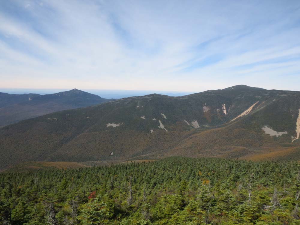
Mt. Garfield and South Twin as seen from West Bond

The Bondcliff Trail on the way to Mt. Bond

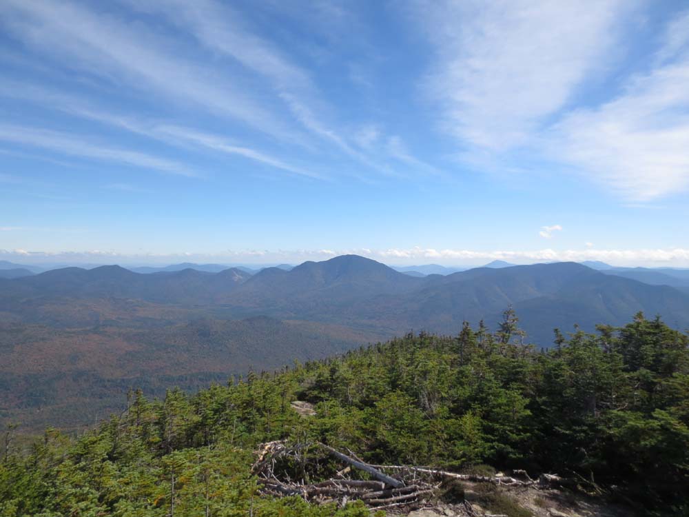
Looking at Mt. Carrigain from Mt. Bond

The Bondcliff Trail on the way to West Bond

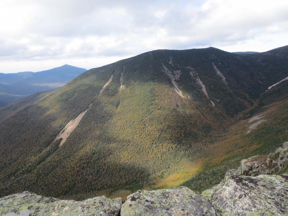
The V Guitar Slide (left) as seen from Bondcliff


Directions to trailhead: To get to Lincoln Woods, take Route 112 East from I-93 past Loon to the Lincoln Woods WMNF fee parking area (left side of road).
Back to West Bond Profile
Back to Mt. Bond Profile
Back to Bondcliff Profile
|