Home
States
Colorado
Connecticut
Maine
Massachusetts
New Hampshire
New York
Rhode Island
Utah
Vermont
View All
Lists
NE 4,000 Footers
NE 100 Highest
NH 4,000 Footers
NH 100 Highest
NH 52 With A View
NH Belknap Range
NH Ossipee 10
Links
Trail Conditions
Trip Log
Sunrises
Sunsets
About
|
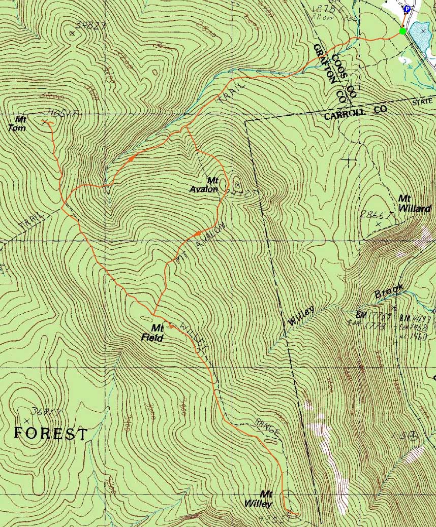
Mt. Field, Mt. Willey, Mt. Tom
Carroll, NH, Bethlehem, NH
Trailheads, measurements, times, distances, and maps are all approximate and relative to the hike(s) as shown below.

Looking up the Avalon Trail
Route: Avalon Trail, Willey Range Trail, (Mt. Field), Willey Range Trail, (Mt. Willey), Willey Range Trail, (Mt. Field), Willey Range Trail, A-Z Trail, Mt. Tom Spur Trail, (Mt. Tom), Mt. Tom Spur Trail, A-Z Trail, Avalon Trail
Even though the forecast was calling for some snow and increasing winds, I wanted to get some exercise. Starting at Crawford Notch, skies were cloudy and snow was lightly falling. The ascent went fairly smoothly, as the water crossings were nicely bridged and the trail generally covered in snow. Nearing Mt. Avalon, I opted to bypass it, as it seemed like there wouldn't be much in way of views. While this was somewhat the case, I did notice a slight undercast as I climbed to Mt. Field, which would quickly move out.
After reaching Mt. Field and having cloudy views, I continued to Mt. Willey on the slightly drifted Willey Range Trail. Upon reaching Mt. Willey, I had some slight blue skies and Southern Presidential views, as the snow started to let up.
Back on Mt. Field, the views had improved, with Mt. Tom, the Dartmouth Range, and the lower slopes of the Presidentials easily seen.
After heading down the previously-barebooted Willey Range Trail, I eventually reached the Mt. Tom Spur, which was a snow-packed-sidewalk. Upon reaching the summit, I was pleasantly surprised with the views. Though the skies were mostly cloudy, I could see most of the Southern White Mountains, as well as the Pemi peaks and some the Eastern Slope peaks.
The descent went smoothly and I was done well before sunset, as skies started to clear.
| Hike Ratings |
|
Getting To Trailhead: |
Easy |
| Destination: |
Mt. Field |
|
Length: |
Moderate |
|
Steepness: |
Difficult |
|
Navigation: |
Moderate |
|
Views: |
Moderate (due to weather) |
|
Crowds: |
Minimal |
| Destination: |
Mt. Willey |
|
Length: |
Moderate |
|
Steepness: |
Difficult |
|
Navigation: |
Difficult |
|
Views: |
Excellent |
|
Crowds: |
Minimal |
| Destination: |
Mt. Field |
|
Length: |
Moderate |
|
Steepness: |
Difficult |
|
Navigation: |
Easy |
|
Views: |
Excellent |
|
Crowds: |
Minimal |
| Destination: |
Mt. Tom |
|
Length: |
Moderate |
|
Steepness: |
Difficult |
|
Navigation: |
Easy |
|
Views: |
Excellent |
|
Crowds: |
Minimal |
|
| Hike Stats |
|
Date Hiked: |
Wednesday, February 10, 2010 |
| Hike Commenced: |
12:13 PM |
| Parking Elevation: |
1,900' |
| Destination: |
Mt. Field |
| Ascent Commenced: |
12:16 PM |
| Summit Reached: |
1:34 PM |
| Time Elapsed: |
01:18 |
| Trailhead Elevation: |
1,900' |
| Summit Elevation: |
4,340' |
| Distance: |
2.8 miles |
| Vertical Gain: |
2,542' |
| Destination: |
Mt. Willey |
| Ascent Commenced: |
1:36 PM |
| Summit Reached: |
2:09 PM |
| Time Elapsed: |
00:33 |
| Trailhead Elevation: |
4,340' |
| Summit Elevation: |
4,285' |
| Distance: |
1.4 miles |
| Vertical Gain: |
465' |
| Destination: |
Mt. Field |
| Ascent Commenced: |
2:11 PM |
| Summit Reached: |
2:47 PM |
| Time Elapsed: |
00:36 |
| Trailhead Elevation: |
4,285' |
| Summit Elevation: |
4,340' |
| Distance: |
1.4 miles |
| Vertical Gain: |
520' |
| Destination: |
Mt. Tom |
| Ascent Commenced: |
2:47 PM |
| Summit Reached: |
3:22 PM |
| Time Elapsed: |
00:35 |
| Trailhead Elevation: |
4,340' |
| Summit Elevation: |
4,051' |
| Distance: |
1.5 miles |
| Vertical Gain: |
411' |
|
|
| Hike Ended: |
4:26 PM |
| Hike Time Elapsed: |
04:13 |
| Hike Distance: |
9.8 miles |
| Hike Vertical Gain: |
3,978' |
|

The Avalon Trail trailhead next to the train station

Mt. Tom and Mt. Martha as seen from the Mt. Field viewpoint

The Willey Range Trail to Mt. Willey

Looking at Mt. Jackson and Mt. Webster from one of the Mt. Willey viewpoints

The Willey Range Trail

Looking at Mt. Carrigain (left) and Mt. Bond (right) from near the summit of Mt. Tom


Directions to trailhead: Take Route 302 west from Bartlett, NH. In the winter, there is plowed parking available at the Highland Center. Trailhead is across the tracks, next to the Crawford Depot.
Back to Mt. Field Profile
Back to Mt. Willey Profile
Back to Mt. Tom Profile
|