Home
States
Colorado
Connecticut
Maine
Massachusetts
New Hampshire
New York
Rhode Island
Utah
Vermont
View All
Lists
NE 4,000 Footers
NE 100 Highest
NH 4,000 Footers
NH 100 Highest
NH 52 With A View
NH Belknap Range
NH Ossipee 10
Links
Trail Conditions
Trip Log
Sunrises
Sunsets
About
|
Mt. Jackson, Mt. Pierce
Carroll, NH, Hart's Location, NH, Bean's Grant, NH, Crawford's Purchase
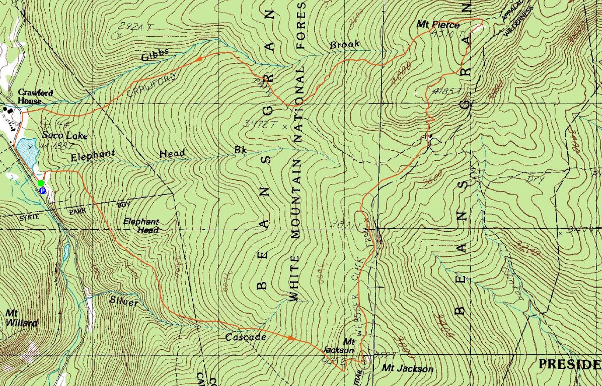
Trailheads, measurements, times, distances, and maps are all approximate and relative to the hike(s) as shown below.

Looking up the steep, rocky section of the Webster-Jackson Trail just below the summit of Mt. Jackson
Route: Webster-Jackson Trail, (Mt. Jackson), Webster Cliff Trail, (Mt. Pierce), Webster Cliff Trail, Crawford Path
After pretty much a week plus of rainy weather, the forecast finally showed a break - thus I took a break from work and headed up to Crawford Notch.
The Webster-Jackson Trail was rather wet due to all of the recent rain - a combination of mud, running water, and standing water. The brook crossings were a little bit tricky, but still not too bad. The bugs weren't bad at all. The ledgy sections below the summit were a bit tricky as well, due to the moisture.
The views from the Mt. Jackson summit were excellent - Mt. Washington was in the clouds, but pretty much everywhere else wasn't.
The descent from Mt. Jackson down the Webster Cliff Trail was rather steep at first - ledgy and rocky. After that, it was fairly gradual all the way to the Mizpah Springs Hut. I especially enjoyed the stretchs of trails that went through mountaintop meadows/marshes - pretty scenic! Up to the hut, I saw very few people. Starting at the hut (where I stopped for an awesome brownie), after the steep ascent up toward Mt. Pierce, there were dozens of folks on the trail. I found the peak before Mt. Pierce to be rather scenic, as it provided views that Pierce only has in the winter (due to snowpack).
Once I reached Mt. Pierce, I decided to stop for lunch and enjoy the views of Mt. Washington - now mostly out of the clouds. After spending a decent amount of time there, I headed down the not-as-wet Crawford Path, stopping at Gibbs Falls near the bottom - the falls sounded like constant thunder from up on the trail and didn't disappoint!
Though I'm not a fan of roadwalks, the short walk from the Crawford Path up 302 back to where I parked wasn't too bad. Finally, a nice day outside!
| Hike Ratings |
|
Getting To Trailhead: |
Easy |
| Destination: |
Mt. Jackson |
|
Length: |
Moderate |
|
Steepness: |
Difficult |
|
Navigation: |
Easy |
|
Views: |
Excellent |
|
Crowds: |
Minimal |
| Destination: |
Mt. Pierce |
|
Length: |
Moderate |
|
Steepness: |
Difficult |
|
Navigation: |
Easy |
|
Views: |
Excellent |
|
Crowds: |
Heavy |
|
| Hike Stats |
|
Date Hiked: |
Friday, July 25, 2008 |
| Hike Commenced: |
8:51 AM |
| Parking Elevation: |
1,900' |
| Destination: |
Mt. Jackson |
| Ascent Commenced: |
8:52 AM |
| Summit Reached: |
10:31 AM |
| Time Elapsed: |
01:39 |
| Trailhead Elevation: |
1,905' |
| Summit Elevation: |
4,052' |
| Distance: |
2.6 miles |
| Vertical Gain: |
2,322' |
| Destination: |
Mt. Pierce |
| Ascent Commenced: |
10:38 AM |
| Summit Reached: |
12:00 PM |
| Time Elapsed: |
01:12 |
| Trailhead Elevation: |
4,052' |
| Summit Elevation: |
4,310' |
| Distance: |
2.5 miles |
| Vertical Gain: |
816' |
|
|
| Hike Ended: |
2:12 PM |
| Hike Time Elapsed: |
05:21 |
| Hike Vertical Gain: |
3,183 |
|

Webster-Jackson Trail trailhead on Route 302

A big bird hanging out on the summit of Mt. Jackson

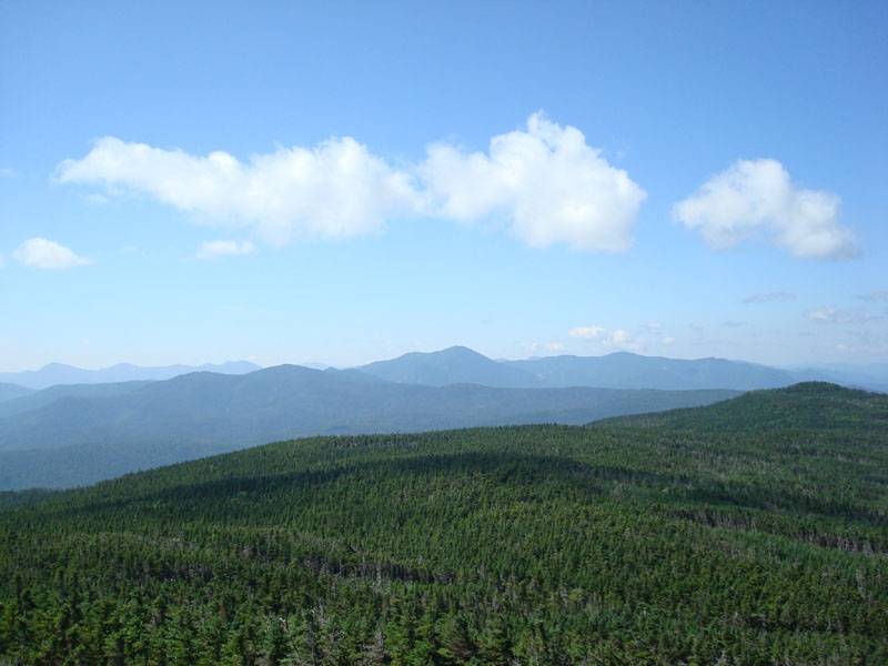
Looking southeast at Mt. Carrigain from the summit of Mt. Jackson

The Webster Cliff Trail to Mt. Pierce

Gibbs Falls near the bottom of the Crawford Path

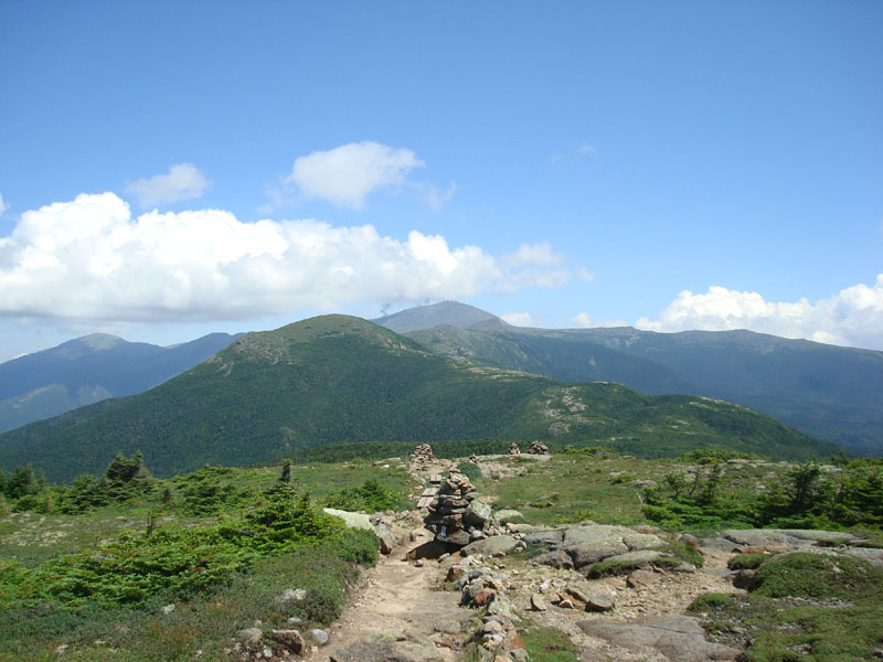
Looking Mt. Eisenhower and Mt. Washington from near the Mt. Pierce summit


Directions to trailhead: Take Route 302 West from Bartlett into Carroll. There is a small parking lot on the left side of the road. Trailhead is located on the right side of the road, just after the parking lot and just before Saco Lake.
Back to Mt. Jackson Profile
Back to Mt. Pierce Profile
|