Home
States
Colorado
Connecticut
Maine
Massachusetts
New Hampshire
New York
Rhode Island
Utah
Vermont
View All
Lists
NE 4,000 Footers
NE 100 Highest
NH 4,000 Footers
NH 100 Highest
NH 52 With A View
NH Belknap Range
NH Ossipee 10
Links
Trail Conditions
Trip Log
Sunrises
Sunsets
About
|
Mt. Jackson
Carroll, NH, Hart's Location, NH, Bean's Grant, NH
Trailheads, measurements, times, distances, and maps are all approximate and relative to the hike(s) as shown below.

Looking up the Webster-Jackson Trail near the summit
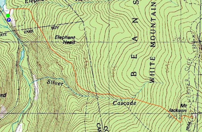
Route: Webster-Jackson Trail
Since I knew the weather wasn't going to be great, and that the next day was going to be very unpleasant, I decided to head up to Mt. Jackson and get a workout on a trail that I otherwise find a bit poor.
Arriving at the trailhead with some sun barely visible through increasing clouds, I donned Microspikes and headed up the Webster-Jackson Trail. The trail was a mix of snow monorail, blue ice, and mud up to Bugle Cliff. Beyond there, it was monorail to the Webster-Jackson split, and then mostly frozen granular up to the ledges (which were bare).
As has been the case when visiting Mt. Jackson, the summit was once again quite windy - this time, however, was a bit different, in that the winds were coming out of the southeast. Even though the skies were cloudy, the views were quite good - the rest of the Presidentials were in the clear and peaks in Vermont were easily seen.
The descent went relatively quickly, as I reached the trailhead before dark, and before the rain had moved in. Not too bad for a cloudy Monday afternoon!
| Hike Ratings |
|
Getting To Trailhead: |
Easy |
| Destination: |
Mt. Jackson |
|
Length: |
Moderate |
|
Steepness: |
Difficult |
|
Navigation: |
Easy |
|
Views: |
Excellent |
|
Crowds: |
Minimal |
|
| Hike Stats |
|
Date Hiked: |
Monday, April 20, 2009 |
| Hike Commenced: |
5:09 PM |
| Parking Elevation: |
1,900' |
| Destination: |
Mt. Jackson |
| Ascent Commenced: |
5:09 PM |
| Summit Reached: |
6:26 PM |
| Time Elapsed: |
01:17 |
| Trailhead Elevation: |
1,905' |
| Summit Elevation: |
4,052' |
| Distance: |
2.6 miles |
| Vertical Gain: |
2,322' |
|
|
| Hike Ended: |
7:41 PM |
| Hike Time Elapsed: |
02:32 |
| Hike Distance: |
5.2 miles |
| Hike Vertical Gain: |
2,512' |
|

Webster-Jackson Trail trailhead on Route 302

Looking at Mt. Carrigain from Mt. Jackson


Directions to trailhead: Take Route 302 West from Bartlett into Carroll. There is a small parking lot on the left side of the road. Trailhead is located on the right side of the road, just after the parking lot and just before Saco Lake.
Back to Mt. Jackson Profile
|