Home
States
Colorado
Connecticut
Maine
Massachusetts
New Hampshire
New York
Rhode Island
Utah
Vermont
View All
Lists
NE 4,000 Footers
NE 100 Highest
NH 4,000 Footers
NH 100 Highest
NH 52 With A View
NH Belknap Range
NH Ossipee 10
Links
Trail Conditions
Trip Log
Sunrises
Sunsets
About
|
Mt. Jackson
Carroll, NH, Hart's Location, NH, Bean's Grant, NH
Trailheads, measurements, times, distances, and maps are all approximate and relative to the hike(s) as shown below.

Looking down the Webster-Jackson Trail
Route: Webster-Jackson Trail
After a foggy morning, I had a feeling things might be starting to clear in the mountains. Thus, I took my time heading north, trying not to let the occasional rain deter mine. Reaching the trailhead, I could see some spots of blue sky - a good sign!
I had to take my time ascending and descending the Webster-Jackson Trail, as the poor footing even worse than normal due to wet roots and rocks. The water crossings were fortunately not an issue.
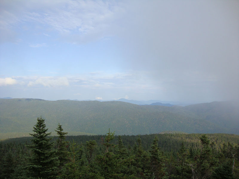
The views from the summit were neat, as fog was racing over the ridge at a fast pace. While the Willey Range and balance of the Presidentials were playing hide and seek, the views to the east were nonetheless constant and strong.
| Hike Ratings |
|
Getting To Trailhead: |
Easy |
| Destination: |
Mt. Jackson |
|
Length: |
Moderate |
|
Steepness: |
Difficult |
|
Navigation: |
Easy |
|
Views: |
Excellent |
|
Crowds: |
Minimal |
|
| Hike Stats |
|
Date Hiked: |
Monday, August 24, 2009 |
| Hike Commenced: |
4:18 PM |
| Parking Elevation: |
1,900' |
| Destination: |
Mt. Jackson |
| Ascent Commenced: |
4:18 PM |
| Summit Reached: |
5:50 PM |
| Time Elapsed: |
01:32 |
| Trailhead Elevation: |
1,905' |
| Summit Elevation: |
4,052' |
| Distance: |
2.6 miles |
| Vertical Gain: |
2,322' |
|
|
| Hike Ended: |
7:33 PM |
| Hike Time Elapsed: |
03:15 |
| Hike Distance: |
5.2 miles |
| Hike Vertical Gain: |
2,512' |
|

Webster-Jackson Trail trailhead on Route 302

Looking down the Webster-Jackson Trail

Looking over the Montalban Ridge at Kearsarge North Mountain from Mt. Jackson


Directions to trailhead: Take Route 302 West from Bartlett into Carroll. There is a small parking lot on the left side of the road. Trailhead is located on the right side of the road, just after the parking lot and just before Saco Lake.
Back to Mt. Jackson Profile
|