Home
States
Colorado
Connecticut
Maine
Massachusetts
New Hampshire
New York
Rhode Island
Utah
Vermont
View All
Lists
NE 4,000 Footers
NE 100 Highest
NH 4,000 Footers
NH 100 Highest
NH 52 With A View
NH Belknap Range
NH Ossipee 10
Links
Trail Conditions
Trip Log
Sunrises
Sunsets
About
|
Mt. Jackson
Carroll, NH, Hart's Location, NH, Bean's Grant, NH
Trailheads, measurements, times, distances, and maps are all approximate and relative to the hike(s) as shown below.

The Webster-Jackson Trail
Route: Webster-Jackson Trail
Still full, deep snowpack, even after the warm rain yesterday. A dusting of snow this morning drifted in the trail in places up high.
I briefly considered going with spikes, and they probably would have been adequate this afternoon/evening with the colder, windy weather, but in the end I was happier with snowshoes. Fortunately the last users of the trail during the warmup wore snowshoes, so it was a relatively smooth footbed (albeit with some residual bareboot postholes sprinkled in). Up high, the dusting had filled in the trough in places. Fortunately this trail is generally obvious, but this could cause some trail finding elsewhere (and if you're trailfinding with this much snowpack, you need snowshoes, as the unpacked snow will not support boots).
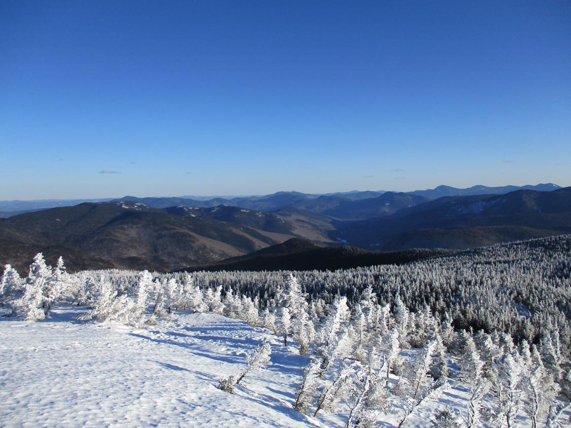
The very top of the trail had a short stretch of monorail and a little blue ice, but the bulk of the summit cone on this side looked bare. The snowpack was as such that I could snowshoe along the base of the ledges in the spruce to the eastern side and go right up on snow. The summit woods are so drifted in right now that the trees are knee high, providing great 360 degree views.
Overall, I would estimate the snowpack ranges from 3 to 6 feet, the former down low and the latter in places up high.
| Hike Ratings |
|
Getting To Trailhead: |
Easy |
| Destination: |
Mt. Jackson |
|
Length: |
Moderate |
|
Steepness: |
Difficult |
|
Navigation: |
Moderate |
|
Views: |
Excellent |
|
Crowds: |
Moderate |
|
| Hike Stats |
|
Date Hiked: |
Monday, April 1, 2019 |
| Parking Elevation: |
1,900' |
| Destination: |
Mt. Jackson |
| Time Elapsed: |
01:19 |
| Trailhead Elevation: |
1,905' |
| Summit Elevation: |
4,052' |
| Distance: |
2.6 miles |
| Vertical Gain: |
2,322' |
|
|
| Hike Time Elapsed: |
02:16 |
| Hike Distance: |
5.2 miles |
| Hike Vertical Gain: |
2,512' |
|

Webster-Jackson Trail trailhead on Route 302

Looking toward Mt. Chocorua from the snowfield atop Mt. Jackson
Directions to trailhead: Take Route 302 West from Bartlett into Carroll. There is a small parking lot on the left side of the road. Trailhead is located on the right side of the road, just after the parking lot and just before Saco Lake.
Back to Mt. Jackson Profile
|