Home
States
Colorado
Connecticut
Maine
Massachusetts
New Hampshire
New York
Rhode Island
Utah
Vermont
View All
Lists
NE 4,000 Footers
NE 100 Highest
NH 4,000 Footers
NH 100 Highest
NH 52 With A View
NH Belknap Range
NH Ossipee 10
Links
Trail Conditions
Trip Log
Sunrises
Sunsets
About
|
Mt. Lowell, Mt. Anderson
Livermore, NH, Lincoln, NH
Trailheads, measurements, times, distances, and maps are all approximate and relative to the hike(s) as shown below.

The Carrigain Notch Trail on the way to Mt. Lowell
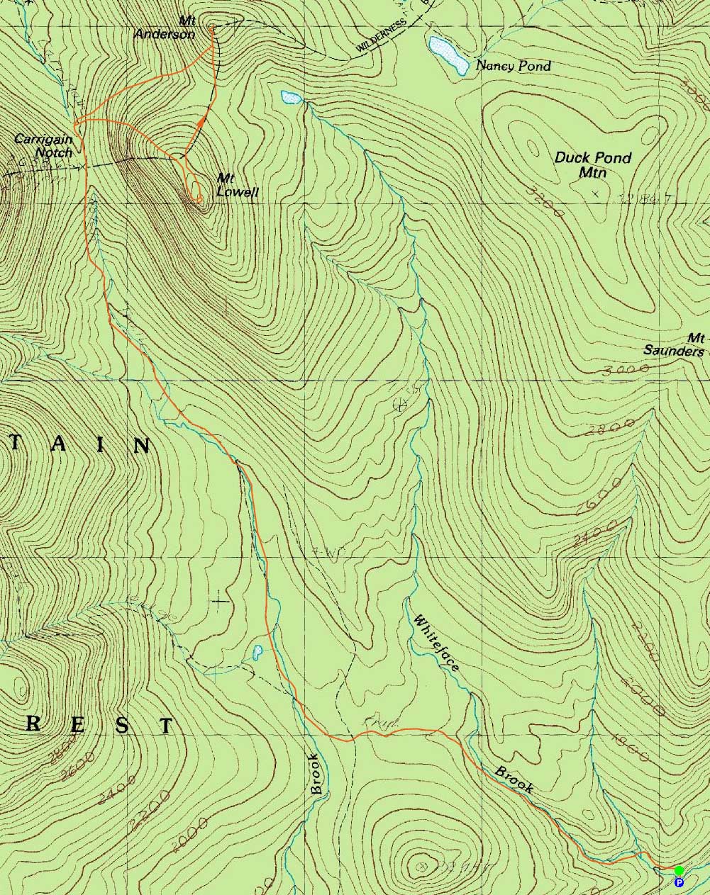
Route: Signal Ridge Trail, Carrigain Notch Trail, bushwhack, (Mt. Lowell), bushwhack, (Mt. Anderson), bushwhack, Carrigain Notch Trail, Signal Ridge Trail
With a good weather forecast, I decided to return to Mt. Lowell and hopefully get views.
Starting out under clear skies, we made decent time up to Carrigain Notch. Tricky water crossings slowed us - not due to levels per se, but due to ice covered rocks.
Shortly after passing over Carrigain Notch, we headed into the woods and up to side of Mt. Lowell, staying to the north of the slides. Though not ideal, the woods weren't terrible per se. Eventually reaching the ridge, now under cloudy skies (forecast?), we worked our way toward the summit, passing through a very scenic scrub/quasi-alpine area.
After reaching the recognized summit, we turned back and worked our way to Anderson. Though we tried to move around a bit, we couldn't seem to find any decent woods - rather, we generally found somewhat thick spruce and various blowdowns, as well as the occasional rocky dropoff to contend with. Eventually reaching the mossy col, we took a break in the rare, somewhat open area, then continued up to Anderson.
Still fairly thick, we did find a few very brief, more open areas. Nonetheless, it was fairly slow and progressively steep going. Nearing the top we reached a series of cliffs with progressively better views - perhaps the best of which was located just before the summit. From this ledge, we could see deep into the Pemi, as well as to points east - perhaps 200 degrees of views. Just beyond the ledge, we reached the recognized summit, where we plotted our escape.
After passing back around the cliffy areas, we decided to drop steeply down the face of Anderson first, then slab over lower (rather than go back to the col and down). Though very steep, we did drop down fairly quickly at first. This was only of limited help, though, as we still ended up running into thick spruce and plenty of blowdowns. Perhaps its these woods between the peaks that result in some folks doing a traverse (and thus dropping off the other side of Anderson, down to the Nancy Pond Trail and then out).
Eventually reaching the trail, we climbed back up to the notch and then out. The thick bushwhacks resulted in us running behind schedule and needing to use our headlamps for the last fraction of a mile.
| Hike Ratings |
|
Getting To Trailhead: |
Easy |
| Destination: |
Mt. Lowell |
|
Length: |
Moderate |
|
Steepness: |
Very Difficult |
|
Navigation: |
Difficult |
|
Views: |
Excellent |
|
Crowds: |
Minimal |
| Destination: |
Mt. Anderson |
|
Length: |
Difficult |
|
Steepness: |
Very Difficult |
|
Navigation: |
Difficult |
|
Views: |
Excellent |
|
Crowds: |
Minimal |
|
| Hike Stats |
|
Date Hiked: |
Thursday, November 25, 2010 |
| Hike Commenced: |
7:59 AM |
| Parking Elevation: |
1,370' |
| Destination: |
Mt. Lowell |
| Ascent Commenced: |
8:00 AM |
| Summit Reached: |
11:23 AM |
| Time Elapsed: |
03:23 |
| Trailhead Elevation: |
1,370' |
| Summit Elevation: |
3,740' |
| Vertical Gain: |
2,520' |
| Destination: |
Mt. Anderson |
| Ascent Commenced: |
11:34 AM |
| Summit Reached: |
1:27 PM |
| Time Elapsed: |
01:53 |
| Trailhead Elevation: |
3,740' |
| Summit Elevation: |
3,740' |
| Vertical Gain: |
480' |
|
|
| Hike Ended: |
5:01 PM |
| Hike Time Elapsed: |
09:01 |
| Hike Vertical Gain: |
3,320' |
|

The Signal Ridge Trail trailhead

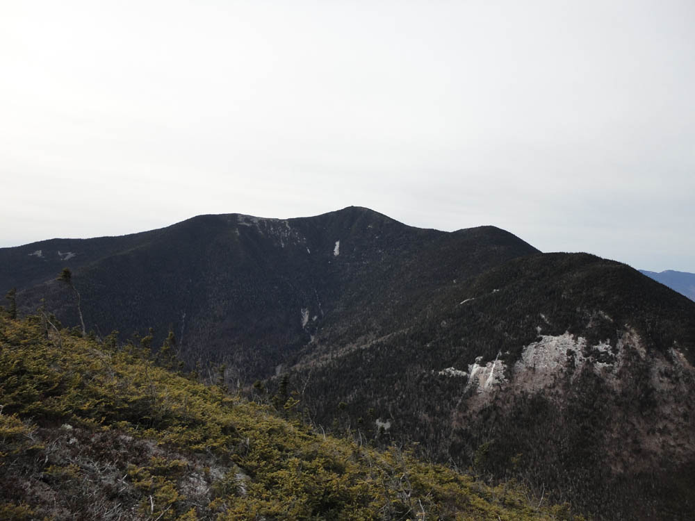
Mt. Carrigain and Vose Spur as seen from near the summit of Mt. Lowell

Brief open woods on the way to Mt. Anderson

The Franconias and Bonds as seen from near the summit of Mt. Anderson


Directions to trailhead: Take Route 302 West from Bartlett to Sawyer River Road. The Signal Ridge Trail parking lot is a few minutes up the dirt road on the left. Trailhead is across the road.
Back to Mt. Lowell Profile
Back to Mt. Anderson Profile
|