Home
States
Colorado
Connecticut
Maine
Massachusetts
New Hampshire
New York
Rhode Island
Utah
Vermont
View All
Lists
NE 4,000 Footers
NE 100 Highest
NH 4,000 Footers
NH 100 Highest
NH 52 With A View
NH Belknap Range
NH Ossipee 10
Links
Trail Conditions
Trip Log
Sunrises
Sunsets
About
|
Mt. Moosilauke
Warren, NH, Woodstock, NH, Benton, NH
Trailheads, measurements, times, distances, and maps are all approximate and relative to the hike(s) as shown below.
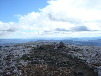
Looking down the Gorge Brook Trail near the Mt. Moosilauke summit
Route: Gorge Brook Trail
With a Red Sox victory late at night, there wasn't much way I was going to get up early the next day. Solution - an easy hike up Mt. Moosilauke.
I was surprised to see a bunch of cars and vans as I drove up the road - some sort of college activity between Dartmouth and Middlebury apparently.
Upon making it to the first bridge, I was passed by the first group of runners going downhill. This would be the first third of the hike - dozens of college kids finishing off some sort of trail race.
The Gorge Brook Trail was rather wet from the recent rain - yet its easy to moderate grades made it somewhat of a breeze to hike.
Soon, probably around 4,000 feet in elevation, I could see rime in the trees. As the trail weaved its way into the shorter spruce stands, the wind picked up big time - wearing shorts and a long sleeve shirt with the sleeves rolled up, it was time to get out the winter gear!
Upon entering the vast summit field, I was greeted with a huge gust of wind - basically making me walk in place for a few seconds. Surprisingly, the wind was a little less at the very summit.
The views were excellent as normal - though not as great as I had hoped, due to the amount of clouds in the sky. Still, I could see a very white Franconia Ridge and some peaks of the white Presidentials.
Not wasting much time (World Series Game 4 was only a few hours away!), I headed back down, getting a lot of curious looks/comments about me wearing shorts in the winter conditions (my legs weren't cold at all!).
The descent was quiet and uneventful - boy was the brook ever running fast from the previous night's rain!
| Hike Ratings |
|
Getting To Trailhead: |
Easy |
| Destination: |
Mt. Moosilauke |
|
Length: |
Moderate |
|
Steepness: |
Moderate |
|
Navigation: |
Easy |
|
Views: |
Excellent |
|
Crowds: |
Heavy |
|
| Hike Stats |
|
Date Hiked: |
Sunday, October 28, 2007 |
| Hike Commenced: |
12:14 PM |
| Parking Elevation: |
2,500' |
| Destination: |
Mt. Moosilauke |
| Ascent Commenced: |
12:19 PM |
| Summit Reached: |
1:52 PM |
| Time Elapsed: |
1:33 |
| Trailhead Elevation: |
2,340' |
| Summit Elevation: |
4,802' |
| Distance: |
3.6 miles |
| Vertical Gain: |
2,512' |
|
|
| Hike Ended: |
3:42 PM |
| Hike Time Elapsed: |
03:28 |
| Hike Vertical Gain: |
2,722' |
|
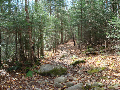
The Gorge Brook Trail trailhead at the end of the Class of 1982 Bridge
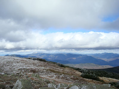
Looking at the Franconia Ridge from the Mt. Moosilauke summit
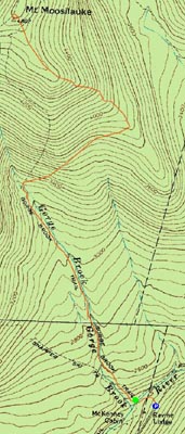

Directions to trailhead: Take Route 112 West to Route 118 south/west. Ravine Road will be on the right shortly after the height of land. Go down this dirt road and bear right. Limited parking available on the side of the road. Walk straight ahead past the kiosk, then take the first left, go left again, then go right across the bridge. The Gorge Brook Trail starts on the left thereafter.
Back to Mt. Moosilauke Profile
|


