Home
States
Colorado
Connecticut
Maine
Massachusetts
New Hampshire
New York
Rhode Island
Utah
Vermont
View All
Lists
NE 4,000 Footers
NE 100 Highest
NH 4,000 Footers
NH 100 Highest
NH 52 With A View
NH Belknap Range
NH Ossipee 10
Links
Trail Conditions
Trip Log
Sunrises
Sunsets
About
|
Mt. Passaconaway, Mt. Whiteface
Albany, NH, Sandwich, NH, Waterville Valley, NH
Trailheads, measurements, times, distances, and maps are all approximate and relative to the hike(s) as shown below.

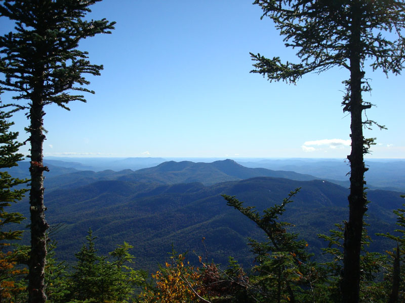
Looking down the Dicey Mill Trail near the Mt. Passaconaway summit
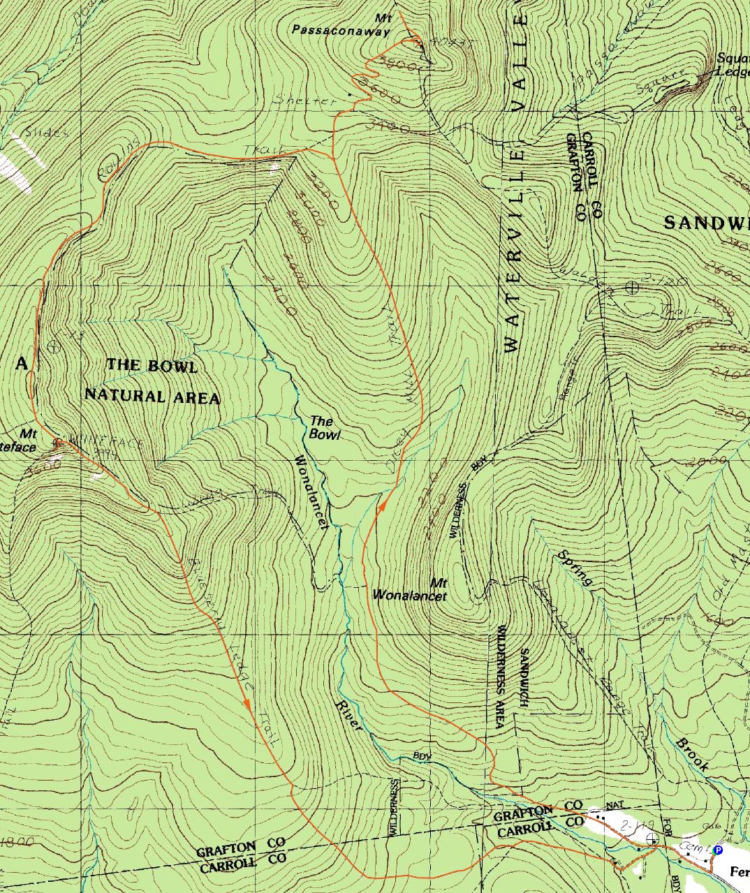
Route: Dicey Mill Trail, (Mt. Passaconaway), East Loop, view spur trail, East Loop, (Mt. Passaconaway), Dicey Mill Trail, Rollins Trail, (Mt. Whiteface), Rollins Trail, (Mt. Whiteface ledges), Blueberry Ledge Trail
I had been saving Mt. Passaconaway and Mt. Whiteface as a 'Plan B' hike for months now. Not able to get enough sleep the night before (due to being pumped up from the Red Sox victory over the Yankees), I decided today would be the day I'd skip driving any sort of distance for a hike.
Arriving at the trailhead after a less than 15 minutes drive from my door, I discovered I was only the second vehicle in the parking lot. By the end of the day, there would be people parking down the road due to a full lot.
And a shpadoinkle day it was! It was about 40 degrees and clear, with the sun just rising over the trees at the edge of the field. My choice was to head up the Dicey Mill Trail to Passaconaway , then head to Whiteface for lunch on the ledges.
The Dicey Mill Trail starts off by backtracking up the road from the parking lot, then heading along a quasi-private road, then driveway, before finally going into the woods. My guess is that a good half mile total is flat, road walking.
Soon, things start to ascend a bit, but never get too steep. In fact, there really isn't much of a pitch at all until after a brook is crossed. Even after that, it's no more than a moderate pitch all the way to the Rollins Trail junction.
Arriving at the Rollins Trail, I was somewhat surprised by how fast and unchallenging the hike had seemed so far. Continuing up the Dicey Mill Trail, things did steepen up a bit for a very brief while, ascending up some rocks/ledges. Before I knew it, I was passing a nice view point and doing the quick walk to the viewless summit.
Since I had arrived about half an hour ahead of what I had planned, I decided to explore a little bit, hitting a view on the East Loop, then doing the .3 mile walk down the 'View' spur (part of the abandoned slide trail). Though a bit of a walk out of the way for a view, it was worth it - great views of Hedgehog, Potash, and of course Mt. Washington.
After making my way back to the summit spur/Dicey Mill Trail junction, it was time to head over to Mt. Whiteface.
Contrary to the TerraServer topo map, the Rollins Trail goes uphill a bit after it leaves the Dicey Mill Trail, before dropping downhill. This first portion of the trail seemed somewhat seldom used compared to the other trails I would hike today - narrow, weeds growing onto the path, etc. It's a fairly neat trail, with multiple view points looking into The Bowl, at Mt. Whiteface, and back at Mt. Passaconaway.
Before I knew it, I was at the cairn marking the top of Mt. Whiteface. Yay. No view of any sort, as expected. After clicking a photo of the cairn and the 'face in the tree' where there used to be a sign from what I've read, I continued down the Rollins Trail for just under 10 minutes, past the Kate Sleeper Trail junction and to the Whiteface ledges - I was the only person there!
But that wouldn't last long. Soon, there were probably over a dozen people up there - it ironically felt a lot like I would picture Mt. Chocorua being on a busy day. No worries. Unfortunately, a cloud lingered near the view point, leaving it in the dark for the 45 minutes that I loitered. Still, amazing views of the lakes, Ossipees, and much of the Sandwich Range.
My path for the descent was the Blueberry Ledge Trail. Though steep at the top, it was a fun trail to take, as there were many ledge viewpoints. While listening to Being There by Wilco and Sam's Town by the Killers, I was amazed how many people I passed - quite a contrast to earlier in the day!
| Hike Ratings |
|
Getting To Trailhead: |
Easy |
| Destination: |
Mt. Passaconaway |
|
Length: |
Moderate |
|
Steepness: |
Difficult |
|
Navigation: |
Easy |
|
Views: |
Excellent |
|
Crowds: |
Minimal |
| Destination: |
Mt. Whiteface |
|
Length: |
Difficult |
|
Steepness: |
Difficult |
|
Navigation: |
Easy |
|
Views: |
Excellent |
|
Crowds: |
Heavy |
|
| Hike Stats |
|
Date Hiked: |
Sunday, September 16, 2007 |
| Hike Commenced: |
7:00 AM |
| Parking Elevation: |
1,140' |
| Destination: |
Mt. Passaconaway |
| Ascent Commenced: |
7:01 AM |
| Summit Reached: |
9:05 AM |
| Time Elapsed: |
02:04 |
| Trailhead Elevation: |
1,140' |
| Summit Elevation: |
4,043' |
| Distance: |
4.6 miles |
| Vertical Gain: |
3,023' |
| Destination: |
Mt. Whiteface |
| Ascent Commenced: |
9:33 AM |
| Summit Reached: |
11:06 AM |
| Time Elapsed: |
01:33 |
| Trailhead Elevation: |
4,035' |
| Summit Elevation: |
4,020' |
| Distance: |
3.1 miles |
| Vertical Gain: |
840' |
|
|
| Hike Ended: |
1:57 PM |
| Hike Time Elapsed: |
06:57 |
| Hike Distance: |
12.6 miles |
| Hike Vertical Gain: |
4,153' |
|

The Dicey Mill Trail trailhead at Ferncroft

Looking east at Mt. Chocorua from near the Mt. Passaconaway summit

The Rollins Trail from Mt. Passaconaway to Mt. Whiteface

Looking south from Mt. Whiteface across the lake to the Belknaps


Directions to trailhead: Take Route 113A to Wonalancet, then take Ferncroft Road. The trailhead (the road) and parking lot are both on the right next to the pasture.
Back to Mt. Passaconaway Profile
Back to Mt. Whiteface Profile
|