Home
States
Colorado
Connecticut
Maine
Massachusetts
New Hampshire
New York
Rhode Island
Utah
Vermont
View All
Lists
NE 4,000 Footers
NE 100 Highest
NH 4,000 Footers
NH 100 Highest
NH 52 With A View
NH Belknap Range
NH Ossipee 10
Links
Trail Conditions
Trip Log
Sunrises
Sunsets
About
|
North Straightback Mountain, Mt. Major
Alton, NH
Trailheads, measurements, times, distances, and maps are all approximate and relative to the hike(s) as shown below.

Looking down the Quarry Spur Trail below North Straightback Mountain
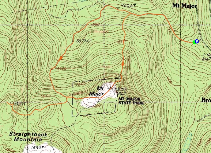
Route: Mt. Major Trail, Brook Trail, Major/Straightback Link, Quarry Spur Trail, Quarry Trail, (North Straightback Mountain), Quarry Trail, Quarry Spur Trail, Major/Straightback Link, (Mt. Major), Mt. Major Trail
The intent was to get to at least one of the Quarry peaks in the eastern Belknap Range. It looked attainable, however extremely slow traffic on 109 started things in the wrong directions.
I had planned on going up the Brook Trail, thinking I could make decent time by cutting on Mt. Major. I decided to bareboot the start of the hike, hoping to make up for lost time. Though things had a bit of an icy glaze over them, I was able to get by for the first portion. After I passed the Mt. Major Trail junction, however, it quickly became posthole city. Time for the snowshoes. The brook crossings were also becoming increasingly tricky - the second to the top one was the most difficult. I don't trust the waterproofing on my cheap hiking boots anymore, so I intended to cross while staying dry. There was no way I was going to do that with my snowshoes on, so off they went. There was still no way to hop across dry rocks, so I ended up going down stream to some fallen trees and crossing there. The snowshoes went back on, and I was on my way, definitely behind schedule.
I forgot how long the Brook Trail really is in comparison to the Mt. Major Trail. By the time I reached the Major/Straightback Link, I was putting serious consideration into just going to Mt. Major and calling it a day. Instead, I continued on, heading up to the Quarry Spur Trail.
No one had been down this trail recently, and as I came around the corner, I could see why - a significant logging operation was underway. While I could follow the trail via ribbon tied around the remaining trees, it wasn't easy going - there was too much snow to bareboot, but the tremendous amounts of branches everywhere made snowshoeing difficult.
As I left that logging area and headed up to the Quarry Trail proper, I saw the top of North Straightback Mountain was also being logged. The summit area didn't feature anything spectacular in way views, so I continued on the Quarry Trail to East Quarry. Finding the trail hard to follow, I decided to bag it (bag meaning give up, rather than collect a peak) and head back to Mt. Major.
The views from Mt. Major were strong as usual - and, once again, I had the summit to myself - a pretty rare thing the rest of the year!
Since I didn't want to deal with the Brook Trail brook crossings, I headed straight down the Mt. Major Trail and was back to the parking lot before sunset. All things considered, not a terrible hike, but I'm definitely ready for winter to be over.
| Hike Ratings |
|
Getting To Trailhead: |
Easy |
| Destination: |
North Straightback Mountain |
|
Length: |
Moderate |
|
Steepness: |
Difficult |
|
Navigation: |
Moderate |
|
Views: |
Excellent |
|
Crowds: |
Minimal |
| Destination: |
Mt. Major |
|
Length: |
Moderate |
|
Steepness: |
Difficult |
|
Navigation: |
Moderate |
|
Views: |
Excellent |
|
Crowds: |
Minimal |
|
| Hike Stats |
|
Date Hiked: |
Wednesday, April 2, 2008 |
| Hike Commenced: |
3:53 PM |
| Parking Elevation: |
585' |
| Destination: |
North Straightback Mountain |
| Ascent Commenced: |
3:53 PM |
| Summit Reached: |
5:20 PM |
| Time Elapsed: |
01:27 |
| Trailhead Elevation: |
600' |
| Summit Elevation: |
1,910' |
| Vertical Gain: |
1,430' |
| Destination: |
Mt. Major |
| Ascent Commenced: |
5:28 PM |
| Summit Reached: |
6:02 PM |
| Time Elapsed: |
00:34 |
| Trailhead Elevation: |
1,910' |
| Summit Elevation: |
1,786' |
| Vertical Gain: |
231' |
|
|
| Hike Ended: |
6:44 PM |
| Hike Time Elapsed: |
02:51 |
| Hike Vertical Gain: |
1,741' |
|

The Mt. Major Trail trailhead at the back of the Route 11 parking lot

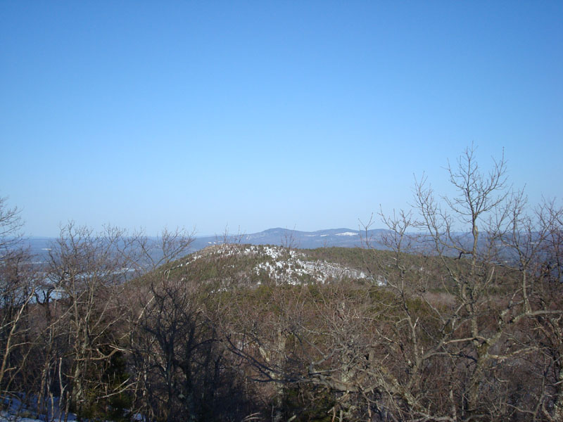
Looking at Mt. Major from near the North Straightback Mountain summit

Heading up the Major/Straightback Link trail to Mt. Major

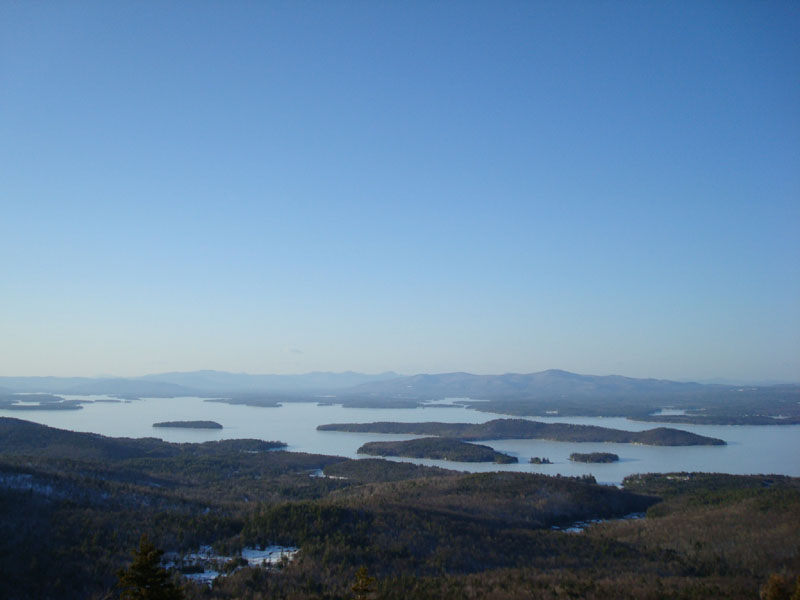
Looking across a still-frozen Lake Winnipesaukee at the Sandwich and Ossipee Ranges from the summit of Mt. Major


Directions to trailhead: Take Route 11 West (north in reality) from Alton Bay. Parking lot and trailhead are on the left after the blasted out section of Route 11.
Back to North Straightback Mountain Profile
Back to Mt. Major Profile
|