Home
States
Colorado
Connecticut
Maine
Massachusetts
New Hampshire
New York
Rhode Island
Utah
Vermont
View All
Lists
NE 4,000 Footers
NE 100 Highest
NH 4,000 Footers
NH 100 Highest
NH 52 With A View
NH Belknap Range
NH Ossipee 10
Links
Trail Conditions
Trip Log
Sunrises
Sunsets
About
|
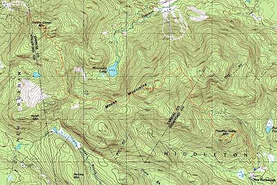
Phoebes Nable Mountain, Moose Mountain, Copple Crown Mountain
Middleton, NH, Brookfield, NH, New Durham, NH
Trailheads, measurements, times, distances, and maps are all approximate and relative to the hike(s) as shown below.

An old logging road on the way to Phoebes Nable Mountain
Route: Logging roads, (Phoebes Nable Mountain), Phoebes Nable Spur, woods road, Moose Mountain Trail, bushwhack, (Moose Mountain), bushwhack, (Copple Crown Mountain), Copple Crown Trail, East Peak Spur, Copple Crown Trail, unnamed trail
After a rain nor'easter and some brisk weather in its wake, we opted to do a hike across the Moose Mountains.
Starting just a bit down the road from the Moose Mountains Reservation parking area, we followed a series of old logging roads up to Phoebe's Nable Mountain, where we had limited (but better than two weeks earlier due to dropping leaves) views.
From there, we headed down past the old Burrows Farm site, then onto the Moose Mountain snowmobile trail. Initially eroded, the condition of the trail improved as we climbed up to some nice ledgy areas.
From the height of land, we followed an increasingly vague trail to the southwest, which eventually faded out. From there, we bushwhacked over a false summit, into a small, steep col, and then up to the true summit of Moose Mountain. Near the ledgy summit area, we found a nice cliff vista with excellent southern views.
After a break there, we proceeded southwest, then north, in generally hardwood stands. Part way up the northern portion of the bushwhack, we hit the only thick section of woods of the day - somewhat thick spruce with lots of blowdowns on and around a small crag. This fortunately didn't last long, as we eventually hit good hardwoods again.
Reaching a marshy area, we were able to obtain a visual on the east cliffs of Copple Crown and worked our way toward them for awhile - until reaching some rocky and cliff areas. We veered west a little bit and instead topped out on Copple Crown proper. After taking in the decent views from the grown in vista, we headed over to the east cliffs, where we had much more expansive views to the south.
From there, we headed back to the Copple Crown Trail, then followed the spur trail down to the top of the old ski area. While there is an old No Trepassing sign at the bottom of the road, there's also a proceed at own risk sign, as well as a recently repaved parking area at the top of the lift.
| Hike Ratings |
|
Getting To Trailhead: |
Easy |
| Destination: |
Phoebes Nable Mountain |
|
Length: |
Moderate |
|
Steepness: |
Easy |
|
Navigation: |
Difficult |
|
Views: |
Moderate |
|
Crowds: |
Minimal |
| Destination: |
Moose Mountain |
|
Length: |
Moderate |
|
Steepness: |
Difficult |
|
Navigation: |
Difficult |
|
Views: |
Excellent |
|
Crowds: |
Minimal |
| Destination: |
Copple Crown Mountain |
|
Length: |
Moderate |
|
Steepness: |
Difficult |
|
Navigation: |
Difficult |
|
Views: |
Excellent |
|
Crowds: |
Minimal |
|
| Hike Stats |
|
Date Hiked: |
Saturday, October 16, 2010 |
| Hike Commenced: |
9:55 AM |
| Parking Elevation: |
670' |
| Destination: |
Phoebes Nable Mountain |
| Ascent Commenced: |
9:55 AM |
| Summit Reached: |
10:26 AM |
| Time Elapsed: |
00:31 |
| Trailhead Elevation: |
640' |
| Summit Elevation: |
1,185' |
| Vertical Gain: |
585' |
| Destination: |
Moose Mountain |
| Ascent Commenced: |
10:37 AM |
| Summit Reached: |
12:04 PM |
| Time Elapsed: |
01:27 |
| Trailhead Elevation: |
1,185' |
| Summit Elevation: |
1,749' |
| Vertical Gain: |
1,069' |
| Destination: |
Copple Crown Mountain |
| Ascent Commenced: |
12:28 PM |
| Summit Reached: |
2:58 PM |
| Time Elapsed: |
02:30 |
| Trailhead Elevation: |
1,749' |
| Summit Elevation: |
1,868' |
| Vertical Gain: |
928' |
|
|
| Hike Ended: |
3:42 PM |
| Hike Time Elapsed: |
05:47 |
| Hike Vertical Gain: |
2,582' |
|

The start of an unmarked logging road near the end of New Portsmouth Road
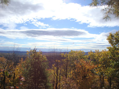
Slight views to the south from Phoebes Nable Mountain

The Moose Mountain snowmobile trail

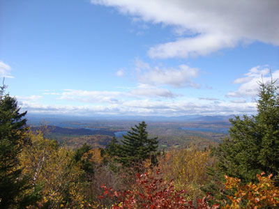
Looking south from near the summit of Moose Mountain

In the woods heading toward Copple Crown

A porcupine near the summit of Moose Mountain
The vista near the summit of Piper Mountain

Directions to trailhead: From Route 16 in the Wakefield-Union area, take Route 153 South. Shortly after leaving Route 125 whilst on 153, take a right onto Ridge Road. A few minutes later, take a right onto New Portsmouth Road. The Moose Mountains Reservation parking lot will be at the end of the road, just prior to a gate. There are multiple logging roads in the vicinity as well.
Back to Phoebes Nable Mountain Profile
Back to Moose Mountain Profile
Back to Copple Crown Mountain Profile
|