Home
States
Colorado
Connecticut
Maine
Massachusetts
New Hampshire
New York
Rhode Island
Utah
Vermont
View All
Lists
NE 4,000 Footers
NE 100 Highest
NH 4,000 Footers
NH 100 Highest
NH 52 With A View
NH Belknap Range
NH Ossipee 10
Links
Trail Conditions
Trip Log
Sunrises
Sunsets
About
|
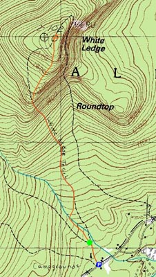
White Ledge
Albany, NH
Trailheads, measurements, times, distances, and maps are all approximate and relative to the hike(s) as shown below.
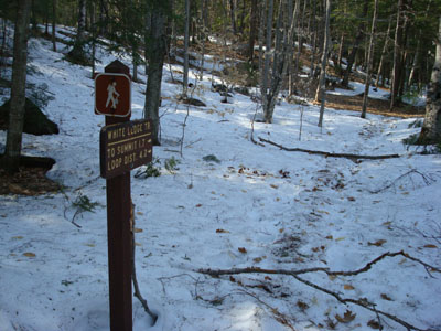
Looking down the White Ledge Trail
Route: White Ledge Trail
Since I had heard reports that portions of the White Ledge area had melted out recently, I decided to check it out for the first time.
Parking at the White Ledge Campground entrance on Route 16 (gate closed), I was a bit annoyed to see that I had driven through some broken glass. Oh well.
Possibly the hardest part of the hike was just getting to the trailhead - the shaded campground road had a good foot or so of spring snow on it, resulting in me postholing a bit.
Upon reaching the trailhead at the back of the campground, the remaining snow was somewhat packed, minimizing postholing. Taking the left (south) leg of the loop, the two brook crossings were a bit tricky but nonetheless doable.
Shortly after the second brook crossing, the snow pretty much disappeared! From there, the trail made a moderate ascent up to the summit.
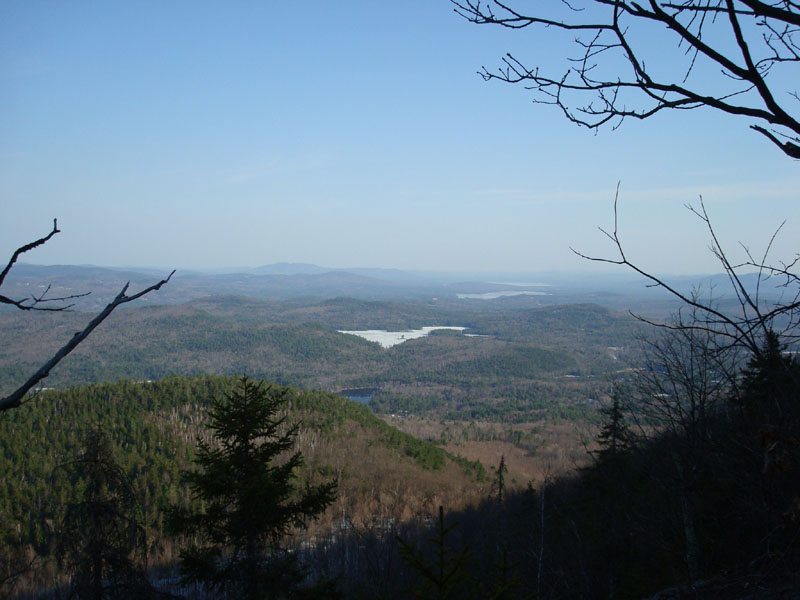
There was still some snow around the summit area, however the ledges were pretty much bare. The views from the various vistas were good, though not quite as good as I hoped.
I poked around the summit area bit, before hearing something rustling out in the bushes. I was unsure of what it was, as I had seen some bear prints and moose droppings on the way up. After taking a few steps, I heard a loud noise and saw a turkey fly out of the bushes.
From there, I descended a bit carefully, as I could smell the faint scent of a skunk.
All in all, not a bad hike. Perhaps I'll try another hike from the campground once it opens (I saw a spot inside the gate for non-camper parking).
| Hike Ratings |
|
Getting To Trailhead: |
Moderate |
| Destination: |
White Ledge |
|
Length: |
Moderate |
|
Steepness: |
Moderate |
|
Navigation: |
Easy |
|
Views: |
Excellent |
|
Crowds: |
Minimal |
|
| Hike Stats |
|
Date Hiked: |
Monday, April 21, 2008 |
| Hike Commenced: |
4:17 PM |
| Parking Elevation: |
730' |
| Destination: |
White Ledge |
| Ascent Commenced: |
4:22 PM |
| Summit Reached: |
5:17 PM |
| Time Elapsed: |
00:55 |
| Trailhead Elevation: |
750' |
| Summit Elevation: |
2,010' |
| Distance: |
1.7 miles |
| Vertical Gain: |
1,295' |
|
|
| Hike Ended: |
6:42 PM |
| Hike Time Elapsed: |
02:25 |
| Hike Vertical Gain: |
1,380' |
|
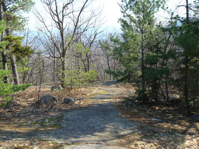
White Ledge Trail trailhead

Looking southeast toward Green Mountain from one of the view points near the White Ledge summit

Directions to trailhead: Take Route 16 North from Tamworth. Shortly after the Piper Trail entrance, the White Ledge Campground will appear on the left. In the off season, there is limited room for parking outside the gate. The White Ledge Trail trailhead is pretty much a straight walk to the back of the campground.
Back to White Ledge Profile
|