Home
States
Colorado
Connecticut
Maine
Massachusetts
New Hampshire
New York
Rhode Island
Utah
Vermont
View All
Lists
NE 4,000 Footers
NE 100 Highest
NH 4,000 Footers
NH 100 Highest
NH 52 With A View
NH Belknap Range
NH Ossipee 10
Links
Trail Conditions
Trip Log
Sunrises
Sunsets
About
|
Zealand Mountain, Mt. Guyot, Mt. Bond (West Peak), Mt. Bond, Bondcliff
Bethlehem, NH, Livermore, NH, Lincoln, NH
Trailheads, measurements, times, distances, and maps are all approximate and relative to the hike(s) as shown below.

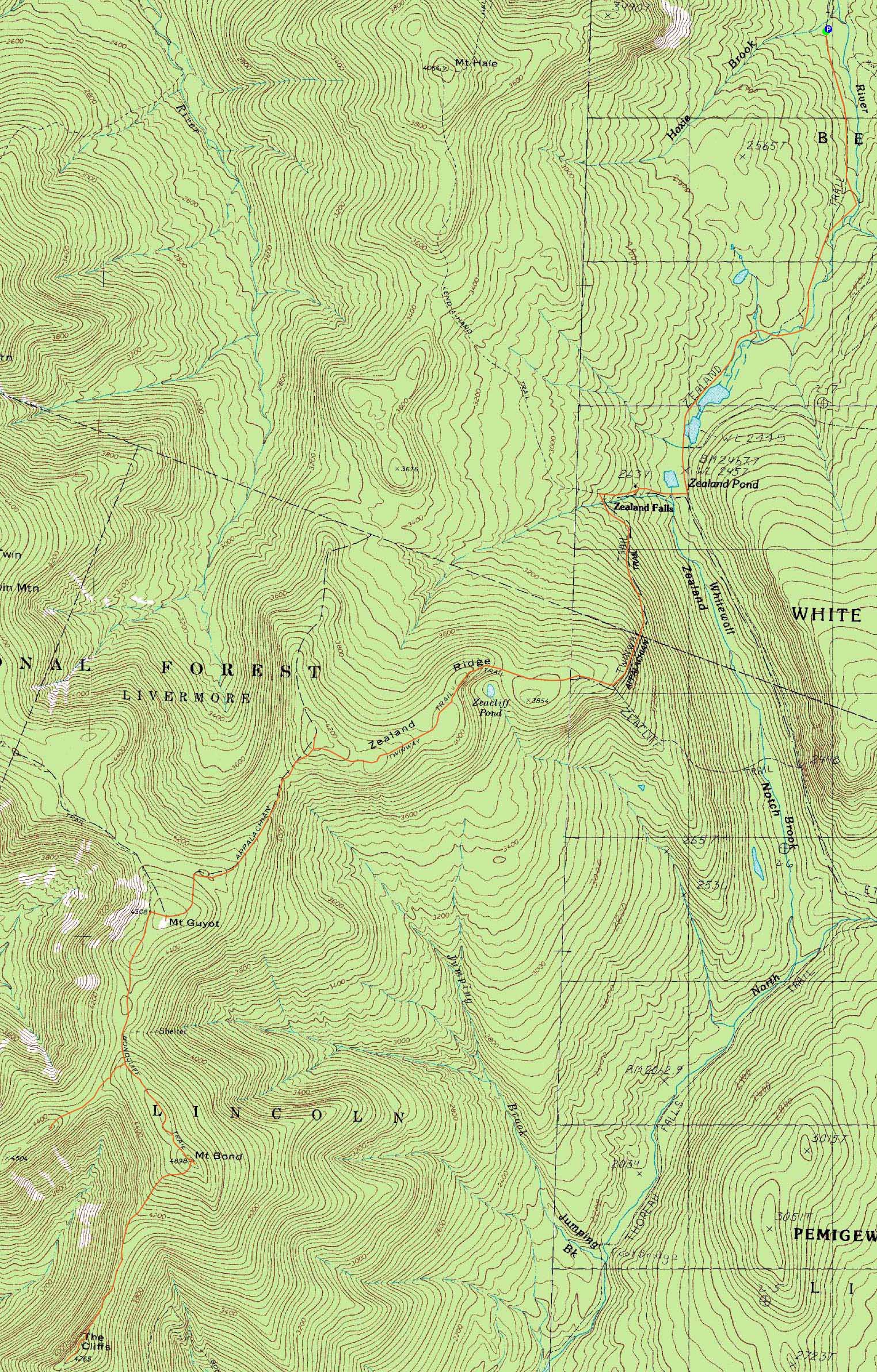
The Zealand Trail
Route: Zealand Trail, Twinway, spur trail, (Zealand Mountain), spur trail, Twinway, (Mt. Guyot), Twinway, Bondcliff Trail, West Bond Trail, (West Bond), West Bond Trail, Bondcliff Trail, (Mt. Bond), Bondcliff Trail, (Bondcliff), Bondcliff Trail, (Mt. Bond), Bondcliff Trail, Twinway, (Mt. Guyot), Twinway, Zealand Trail
While I had been planning to head up to Baxter for five days, Duke Duke Duke Duke of Earl was threatening to hit. Not wanting to experience a hurricane in a tent, I opted to wait it out and hike locally in the extremely warm (90s in the valleys) weather.
Starting at Zealand Road, I tiptoed up the Zealand Trail, hoping to perhaps bump into a moose. No such luck, probably because I started half an hour or so too late. Nonetheless, it was a nice walk as the sun just started to poke over the ridge.
After the steep climb up to the Zeacliff area, I worked my way across the ridge and to the summit of Zealand Mountain. While it was tempting to do some exploring near the summit, I still had nearly 15 miles left to hike.
The next section of the Twinway is one of my least favorites - very poor footing in places - mucho boulders. Nonetheless, it was worth it as I reached the summit of Guyot with decent, though hazy views. A nice breeze helped keep the temperature bearable.
After passing the Guyot campsite, I dropped my pack for the half mile walk to West Bond, where I again had nice, though hazy views and a decent breeze.
Back on the Bondcliff Trail, I worked my way up to Bond and was glad to see the makeshift prison wall of scree and branches had been scaled back. After checking out the views, I headed down to Bondcliff.
The ridge walk was quite nice, and the wind once again rather welcome. Reaching the summit, I took some time to enjoy the views. The direct sun and increasing heat prodded me to get going after a bit, so I turned back and worked my way up the now-grueling climb back to Bond.
While I had considered having lunch here, I decided to keep moving and find a cooler, shady spot. A sub-col near the Guyot campsite spur sufficed.
After passing back over Guyot (with slightly stronger views than earlier), I put on my headset and listened to some talk radio as I worked my way back across the now hot Zealand Ridge. After splashing some cool water from the brook crossing on my face and a quick stop for lemonade at the hut, I zoned in, or out for that matter, on the Zealand Trail walk back to the parking lot. A rare stop in the river was in store shortly thereafter, as the heat was getting unbearable!
| Hike Ratings |
|
Getting To Trailhead: |
Easy |
| Destination: |
Zealand Mountain |
|
Length: |
Moderate |
|
Steepness: |
Difficult |
|
Navigation: |
Easy |
|
Views: |
Minimal |
|
Crowds: |
Minimal |
| Destination: |
Mt. Guyot |
|
Length: |
Difficult |
|
Steepness: |
Difficult |
|
Navigation: |
Easy |
|
Views: |
Excellent |
|
Crowds: |
Minimal |
| Destination: |
Mt. Bond (West Peak) |
|
Length: |
Very Difficult |
|
Steepness: |
Difficult |
|
Navigation: |
Easy |
|
Views: |
Excellent |
|
Crowds: |
Minimal |
| Destination: |
Mt. Bond |
|
Length: |
Very Difficult |
|
Steepness: |
Difficult |
|
Navigation: |
Easy |
|
Views: |
Excellent |
|
Crowds: |
Minimal |
| Destination: |
Bondcliff |
|
Length: |
Very Difficult |
|
Steepness: |
Difficult |
|
Navigation: |
Easy |
|
Views: |
Excellent |
|
Crowds: |
Minimal |
|
| Hike Stats |
|
Date Hiked: |
Thursday, September 2, 2010 |
| Hike Commenced: |
6:46 AM |
| Parking Elevation: |
2,000' |
| Destination: |
Zealand Mountain |
| Ascent Commenced: |
6:47 AM |
| Summit Reached: |
9:01 AM |
| Time Elapsed: |
02:14 |
| Trailhead Elevation: |
2,000' |
| Summit Elevation: |
4,260' |
| Distance: |
5.7 miles |
| Vertical Gain: |
2,490' |
| Destination: |
Mt. Guyot |
| Ascent Commenced: |
9:05 AM |
| Summit Reached: |
9:41 AM |
| Time Elapsed: |
00:36 |
| Trailhead Elevation: |
4,260' |
| Summit Elevation: |
4,580' |
| Distance: |
1.4 miles |
| Vertical Gain: |
640' |
| Destination: |
Mt. Bond (West Peak) |
| Ascent Commenced: |
9:42 AM |
| Summit Reached: |
10:20 AM |
| Time Elapsed: |
00:38 |
| Trailhead Elevation: |
4,580' |
| Summit Elevation: |
4,540' |
| Distance: |
1.3 miles |
| Vertical Gain: |
470' |
| Destination: |
Mt. Bond |
| Ascent Commenced: |
10:23 AM |
| Summit Reached: |
10:53 AM |
| Time Elapsed: |
00:30 |
| Trailhead Elevation: |
4,540' |
| Summit Elevation: |
4,698' |
| Distance: |
1 mile |
| Vertical Gain: |
448' |
| Destination: |
Bondcliff |
| Ascent Commenced: |
10:55 AM |
| Summit Reached: |
11:35 AM |
| Time Elapsed: |
00:40 |
| Trailhead Elevation: |
4,698' |
| Summit Elevation: |
4,265' |
| Distance: |
1.2 miles |
| Vertical Gain: |
285' |
|
|
| Hike Ended: |
4:12 PM |
| Hike Time Elapsed: |
09:26 |
| Hike Distance: |
19.9 miles |
| Hike Vertical Gain: |
6,086' |
|

The Zealand Trail trailhead at the end of Zealand Road

Obstructed views of South Twin from near the summit of Zealand Mountain

The rocky Twinway between Zealand and Guyot is a sick joke at the end of the day

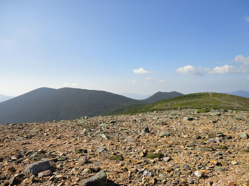
Looking at Mt. Bond, West Bond, and South Guyot from Mt. Guyot
<
The Bondcliff Trail on the way to West Bond

Looking at South Twin and Mt. Guyot from West Bond

The Bondcliff Trail on the way to Mt. Bond

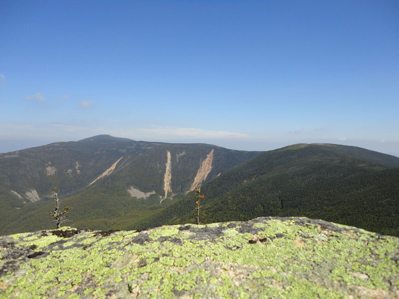
Looking at West Bond and the Franconia Ridge from Mt. Bond
<
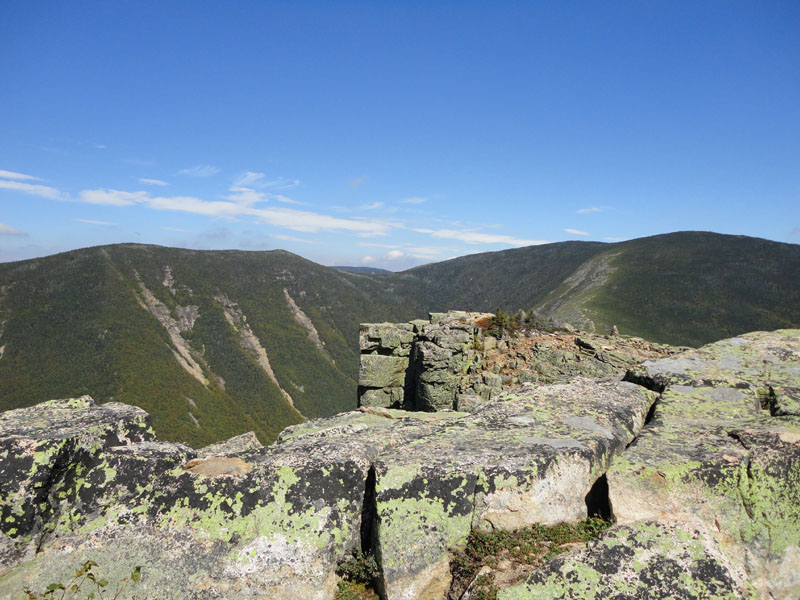
Looking down the Bondcliff Trail at Bondcliff

Looking at West Bond, the famous cliff, and Mt. Bond from the Bondcliff summit


Directions to trailhead: Take US 302 west from Bartlett past Bretton Woods Ski Area. A few minutes after, take a left onto Zealand Road. The Zealand WMNF fee parking area and Zealand Trail trailhead are located at the end of the road.
Back to Zealand Mountain Profile
Back to Mt. Guyot Profile
Back to Mt. Bond - West Peak Profile
Back to Mt. Bond Profile
Back to Bondcliff Profile
|