Home
States
Colorado
Connecticut
Maine
Massachusetts
New Hampshire
New York
Rhode Island
Utah
Vermont
View All
Lists
NE 4,000 Footers
NE 100 Highest
NH 4,000 Footers
NH 100 Highest
NH 52 With A View
NH Belknap Range
NH Ossipee 10
Links
Trail Conditions
Trip Log
Sunrises
Sunsets
About
|
Jay Peak
Westfield, VT
Trailheads, measurements, times, distances, and maps are all approximate and relative to the hike(s) as shown below.

The Long Trail near the Jay Peak summit
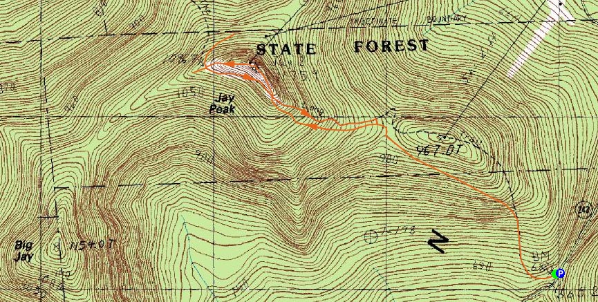
Route: Long Trail, (Jay Peak), Northway, Long Trail, (spur path), Long Trail, Northway, Vermonter, Long Trail
With remnants of a tropical storm of some sort promising to water much of New England, I decided to use the day to go way up north and get a morning hike in.
After getting up wicked early, I was at the Long Trail trailhead on 242 around 8:00 - first person there!
The trail steepness is moderate at best, coming up the backside of the Jay Peak ski area. Though wet at the bottom, most of the trail was dry due to the below freezing temperatures.
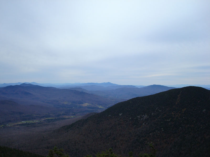
Shortly after a ski trail is visible through the woods, the Long Trail steepens up a bit and gets rocky in places, before crossing over a ski trail and climbing up a bare knob to the summit. Despite the clouds (two days earlier, it was supposed to be mostly sunny, and even this morning it was supposed to be only about 50% cloud coverage, but I guess you can't win them all), the views were very strong - stretching into Canada, over to the Adirondacks, down past Mt. Mansfield, and to the Presidentials in New Hampshire.
My next stop was to be Big Jay - I was curious to see the illegally cut ski trail and also get a 100-highest in New England peak. Heading down the Northway ski trail, and the cutting into the woods via the Long Trail, I quickly found the herd path.
I descended a bit, heard some stronger winds coming from the south, and became annoyed by multiple blow downs. I just wasn't really inspired enough to go the mile, I guess. Quite frankly, I was more interested to see a pure Leitner detachable quad chairlift in person for the first time ever. As a result, I turned around, headed back up to the Northway ski trail, and headed down to the top terminal of the Green Mountain Flyer chairlift.
Wanting to mix it up a bit, I decided to head back up toward the summit, then descend via the steep Vermonter ski trail, and cut through the woods back to the Long Trail. This was worthwhile, as the footing and the views were much better than the woods trail.
All things considered, a decent hike. I'll probably hike this one again if I'm ever in the area on a nice day - and check out Big Jay at that point.
| Hike Ratings |
|
Getting To Trailhead: |
Easy |
| Destination: |
Jay Peak |
|
Length: |
Moderate |
|
Steepness: |
Moderate |
|
Navigation: |
Easy |
|
Views: |
Excellent |
|
Crowds: |
Minimal |
|
| Hike Stats |
|
Date Hiked: |
Saturday, November 3, 2007 |
| Hike Commenced: |
8:02 AM |
| Parking Elevation: |
2,211' |
| Destination: |
Jay Peak |
| Ascent Commenced: |
8:03 AM |
| Summit Reached: |
8:59 AM |
| Time Elapsed: |
00:56 |
| Distance: |
1.6 miles |
| Trailhead Elevation: |
2,205' |
| Summit Elevation: |
3,858' |
| Vertical Gain: |
1,668' |
|
|
| Hike Ended: |
10:35 AM |
| Hike Time Elapsed: |
2:33 |
| Hike Vertical Gain: |
2,042' |
|

The Long Trail trailhead on Route 242

Looking southwest toward Mt. Mansfield from the Jay Peak summit


Directions to trailhead: From the town of Jay, take 242 south to the top of the pass. There is a parking lot on the left. The trailhead is just slightly downhill from this, on the right.
Back to Jay Peak Profile
|