Home
States
Colorado
Connecticut
Maine
Massachusetts
New Hampshire
New York
Rhode Island
Utah
Vermont
View All
Lists
NE 4,000 Footers
NE 100 Highest
NH 4,000 Footers
NH 100 Highest
NH 52 With A View
NH Belknap Range
NH Ossipee 10
Links
Trail Conditions
Trip Log
Sunrises
Sunsets
About
|
General Stark Mountain
Mount Ellen
Cutts Peak
Nancy Hanks Peak
Lincoln Peak
Warren, Fayston, Buel's Gore, VT
Trailheads, measurements, times, distances, and maps are all approximate and relative to the hike(s) as shown below.

Looking north at General Stark Mountain from Mount Ellen
Originally, my intent was to hike from the Appalachian Gap to Mt. Abraham and back. The English/Irish in me wanted to accomplish this, however the injuries, fatigue, and lack of time made the French in me give up before finishing the battle. Nonetheless, I was able to hike from the gap to Lincoln Peak (less than a mile from Mt. Abraham).
The trail is much like a rock and roll band's career - rocky overall with a sudden ascent, dips in the middle, and a downward ending that just seems to take forever (complete with false flashes of hope).
The hike itself is like a kick in the you know where - everytime you get a north vista, the next destination seems way far away. The most boring section is between Mount Ellen and Castlerock - nothing much to see.
Overall, a challenging hike due to the abundance of rocks all over the place, as well as mud pits with log balance beams. Worthwhile, yes, fun, yes, but pain in the butt, yes.
| Hike Ratings |
|
Getting To Trailhead: |
Moderate |
| Destination: |
Sunnyside (ski area summit) |
|
Length: |
Moderate |
|
Steepness: |
Difficult |
|
Navigation: |
Moderate |
|
Views: |
Excellent |
|
Crowds: |
Minimal |
| Destination: |
General Stark Mountain |
|
Length: |
Difficult |
|
Steepness: |
Difficult |
|
Navigation: |
Moderate |
|
Views: |
Excellent |
|
Crowds: |
Minimal |
| Destination: |
Mount Ellen |
|
Length: |
Very Difficult |
|
Steepness: |
Difficult |
|
Navigation: |
Moderate |
|
Views: |
Excellent |
|
Crowds: |
Minimal |
| Destination: |
Cutts Peak |
|
Length: |
Very Difficult |
|
Steepness: |
Moderate |
|
Navigation: |
Moderate |
|
Views: |
Minimal |
|
Crowds: |
Moderate |
| Destination: |
Castle Rock (ski area summit) |
|
Length: |
Very Difficult |
|
Steepness: |
Moderate |
|
Navigation: |
Moderate |
|
Views: |
Excellent |
|
Crowds: |
Moderate |
| Destination: |
Nancy Hanks Peak |
|
Length: |
Very Difficult |
|
Steepness: |
Moderate |
|
Navigation: |
Moderate |
|
Views: |
Excellent |
|
Crowds: |
Moderate |
| Destination: |
Lincoln Peak |
|
Length: |
Very Difficult |
|
Steepness: |
Difficult |
|
Navigation: |
Moderate |
|
Views: |
Excellent |
|
Crowds: |
Moderate |
|
| Hike Stats |
|
Date Hiked: |
Saturday, August 12, 2006 |
| Hike Commenced: |
9:54 AM |
| Parking Elevation: |
2,375' |
| Destination: |
Sunnyside (ski area summit) |
| Ascent Commenced: |
10:00 AM at Appalachian Gap Long Trail trailhead |
| Summit Reached: |
10:41 AM |
| Trailhead Elevation: |
2,387' |
| Summit Elevation: |
3,086' |
| Vertical Gain: |
765' |
| Destination: |
General Stark Mountain (ski area summit) |
| Ascent Commenced: |
10:41 AM |
| Summit Reached: |
11:12 AM |
| Trailhead Elevation: |
3,086' |
| Summit Elevation: |
3,644' |
| Vertical Gain: |
598' |
| Destination: |
General Stark Mountain |
| Ascent Commenced: |
11:15 AM |
| Summit Reached: |
11:34 AM |
| Trailhead Elevation: |
3,644' |
| Summit Elevation: |
3,662' |
| Vertical Gain: |
122' |
| Destination: |
Mount Ellen |
| Ascent Commenced: |
11:34 AM |
| Summit Reached: |
12:29 PM |
| Trailhead Elevation: |
3,662' |
| Summit Elevation: |
4,083' |
| Vertical Gain: |
893' |
| Destination: |
Cutts Peak |
| Ascent Commenced: |
12:29 PM |
| Summit Reached: |
12:39 PM |
| Trailhead Elevation: |
4,083' |
| Summit Elevation: |
4,022' |
| Vertical Gain: |
104' |
| Destination: |
Castlerock (ski area summit) |
| Ascent Commenced: |
12:39 PM |
| Summit Reached: |
1:09 PM |
| Trailhead Elevation: |
4,022' |
| Summit Elevation: |
3,760' |
| Vertical Gain: |
228' |
| Destination: |
Nancy Hanks Peak |
| Ascent Commenced: |
1:10 PM |
| Summit Reached: |
1:27 PM |
| Trailhead Elevation: |
3,760' |
| Summit Elevation: |
3,812' |
| Vertical Gain: |
192' |
| Destination: |
Lincoln Peak |
| Ascent Commenced: |
1:10 PM |
| Summit Reached: |
1:41 PM |
| Trailhead Elevation: |
3,812' |
| Summit Elevation: |
3,975' |
| Vertical Gain: |
235' |
| Hike Ended: |
6:32 PM |
| Hike Vertical Gain: |
4,841' |
|

Long Trail trailhead at Appalachian Gap

Ladder on Long Trail, approaching top of Sunnyside area at Mad River Glen

Top of Sunnyside area at Mad River Glen

Long Trail heading toward General Stark Mountain ski area summit

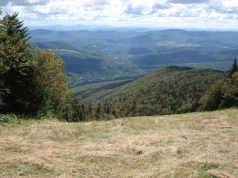
View near General Stark Mountain ski area summit

Long Trail, between General Stark Mountain and Mount Ellen

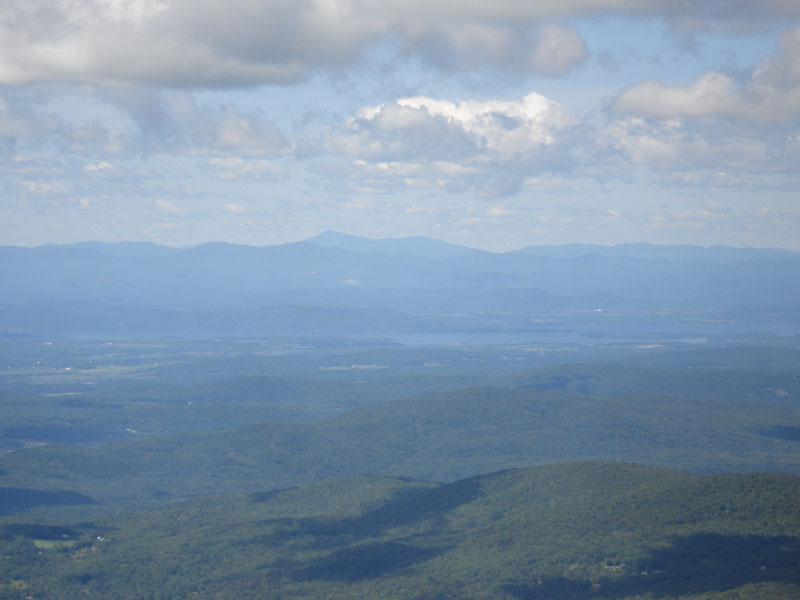
View near Mount Ellen summit, looking northwest at Whiteface, NY and Lake Champlain
Click here for additional photos - Cutts Peak, Nancy Hanks Peak, Lincoln Peak

Click to for very large file

Directions to trailhead: Take Route 100 north to Route 17 north. Parking at Appalachian Gap.
Back to General Stark Mountain profile
Back to Mount Ellen profile
Back to Cutts Peak profile
Back to Nancy Hanks Peak profile
Back to Lincoln Peak profile
|