Home
States
Colorado
Connecticut
Maine
Massachusetts
New Hampshire
New York
Rhode Island
Utah
Vermont
View All
Lists
NE 4,000 Footers
NE 100 Highest
NH 4,000 Footers
NH 100 Highest
NH 52 With A View
NH Belknap Range
NH Ossipee 10
Links
Trail Conditions
Trip Log
Sunrises
Sunsets
About
|
Mt. Abram
Greenwood, ME
Trailheads, measurements, times, distances, and maps are all approximate and relative to the hike(s) as shown below.
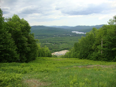
Looking down the Boris Badenov Trail
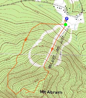
Route: Ski trails
After finishing Goose Eye as a morning hike, we opted to check out something else in the area. Hunting around for a hiking trail or access road up Mt. Abram, we found a few leads, but none promising enough to follow. Instead, we opted to hike up the ski trails. In previous years, the parking lot had been blocked off with No Trespassing signs, however that doesn't appear to be the case now.
We ascended straight up the main race trail, curving around a few of the access trails to reach the summit (the highpoint of which seemed to be next to the summit patrol shack).
While there were some views from the tops of the ski trails, we found the best views by far to be from a clearing adjacent to a communications tower just west of the summit. From here we had excellent views of the Evans Notch area and Presidentials.
For the descent, we followed a more gradual trail. While it was a nice, quick hike, the bugs were bad - ticks and deer flies in particular.
| Hike Ratings |
|
Getting To Trailhead: |
Easy |
| Destination: |
Mt. Abram |
|
Length: |
Moderate |
|
Steepness: |
Difficult |
|
Navigation: |
Easy |
|
Views: |
Excellent |
|
Crowds: |
Minimal |
|
| Hike Stats |
|
Date Hiked: |
Saturday, May 29, 2010 |
| Hike Commenced: |
4:06 PM |
| Parking Elevation: |
940' |
| Destination: |
Mt. Abram |
| Ascent Commenced: |
4:08 PM |
| Summit Reached: |
4:37 PM |
| Time Elapsed: |
00:29 |
| Trailhead Elevation: |
950' |
| Summit Elevation: |
1,990' |
| Vertical Gain: |
1,055' |
|
|
| Hike Ended: |
5:25 PM |
| Hike Time Elapsed: |
01:19 |
| Hike Vertical Gain: |
1,070' |
|
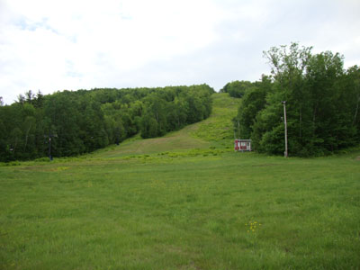
Looking up the Boris Badenov Trail
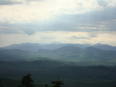
Looking at the Evans Notch and Carter Range peaks in front of Mt. Washington from near the Mt. Abram summit

Directions to trailhead: Take Route 2 east to Route 26 south to Greenwood. The access road for Mt. Abram will eventuall be on the right.
Back to Mt. Abram Profile
|

