Home
States
Colorado
Connecticut
Maine
Massachusetts
New Hampshire
New York
Rhode Island
Utah
Vermont
View All
Lists
NE 4,000 Footers
NE 100 Highest
NH 4,000 Footers
NH 100 Highest
NH 52 With A View
NH Belknap Range
NH Ossipee 10
Links
Trail Conditions
Trip Log
Sunrises
Sunsets
About
|
Mt. Cutler
Hiram, ME
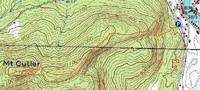
Trailheads, measurements, times, distances, and maps are all approximate and relative to the hike(s) as shown below.
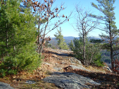
Looking down the Mt. Cutler Trail
Route: Mt. Cutler Trail, bushwack, (Mt. Cutler summit), herd path, Mt. Cutler Trail
With really frigid temperatures in the Whites, I decided to do a much more tame hike on a sunny late fall day. I had been meaning to hike Mt. Cutler for a few months, but had never had the reason to do so.
After crossing the railroad tracks, I headed up the moderately pitched beginning of the Mt. Cutler Trail. Soon, the trail traversed alongside a ledge - there was a short scramble and a lot of views!
After passing the initial ledges, the trail meanders along the ridge, hitting a bunch of false summits. There are a hoard of view points east, south, and north, including superb clear looks at Mt. Washington.
After awhile, I could see the true summit ahead - with a col in between. Up to the col, the trail is decently marked with red blazes and the occasional cairn. Once in the col, good luck! At first, I blindly followed a well worn path that continued in the direction of the blazed path, before quickly realizing I was losing altitude.
Turning around, I walked in the other direction on this path in the col, quickly noting some small cairns on the slope of the peak. There was no obvious path, however with the minimal vegetation and foliage, it was pretty clear where I needed to lightly bushwack to. The terrain was challenging at this point, as it is steep and covered in slippery leaves.
Soon, I was near the top of the peak and back onto a herd path. The proper summit is marked with a cairn on top of a large rock - no views from this point, however.
Just around the corner from the summit, everything opens up big time - excellent views of Burnt Meadow Mountain, parts of the eastern Sandwich Range, Pleasant Mountain, a tremendous view of the Presidentials. This clearing is absolutely covered in wild low bush blueberry vines - I may need to return to this location next August!
On the way back, I was able to follow a herd path down the pitch into the col - come to find out, there were a few more cairns higher up that I couldn't see on my ascent - I tried to gather rocks to build another cairn or two, however most of them were frozen solid into the ground below, so my efforts only resulted in building up the existing cairns a little bit.
Near the end of the hike, I was able to spot a rock lined well next to a stonewall - my guess is this might have something to do with a rumored gold mine in this area years ago.
All in all a nice hike - probably the most scenic non-4,000 footer hike I've done in Maine yet.
| Hike Ratings |
|
Getting To Trailhead: |
Moderate |
| Destination: |
Mt. Cutler |
|
Length: |
Moderate |
|
Steepness: |
Difficult |
|
Navigation: |
Moderate |
|
Views: |
Excellent |
|
Crowds: |
Minimal |
|
| Hike Stats |
|
Date Hiked: |
Saturday, November 24, 2007 |
| Hike Commenced: |
11:32 AM |
| Parking Elevation: |
390' |
| Destination: |
Mt. Cutler |
| Ascent Commenced: |
11:32 AM |
| Summit Reached: |
12:16 PM |
| Time Elapsed: |
00:44 |
| Trailhead Elevation: |
390' |
| Summit Elevation: |
1,232' |
| Vertical Gain: |
1,022' |
|
|
| Hike Ended: |
1:27 PM |
| Hike Time Elapsed: |
01:55 |
| Hike Vertical Gain: |
1,222' |
|
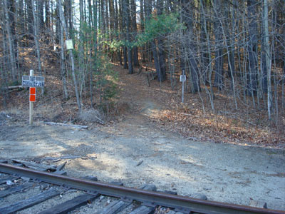
The Mt. Cutler Trail trailhead, just off Mt. View Avenue
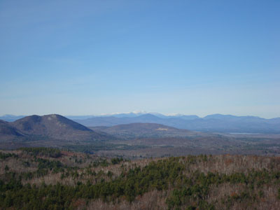
Looking northwest at Mt. Washington from near the Mt. Cutler summit

Directions to trailhead: From Route 25, take Route 5 North to Hiram. Just after 117 departs east from 5/113, cross the bridge (still on 5/113), then take an immediate left onto River Road. Very shortly after, take a right onto Mt. View Avenue. Just after Mt. View Avenue takes a sharp left turn, take a right into a small dirt parking lot next to the railroad tracks. The Mt. Cutler Trail trailhead is across the tracks, a few dozen feet to the south.
Back to Mt. Cutler Profile
|


