Home
States
Colorado
Connecticut
Maine
Massachusetts
New Hampshire
New York
Rhode Island
Utah
Vermont
View All
Lists
NE 4,000 Footers
NE 100 Highest
NH 4,000 Footers
NH 100 Highest
NH 52 With A View
NH Belknap Range
NH Ossipee 10
Links
Trail Conditions
Trip Log
Sunrises
Sunsets
About
|
Peary Mountain
Brownfield, ME
Trailheads, measurements, times, distances, and maps are all approximate and relative to the hike(s) as shown below.
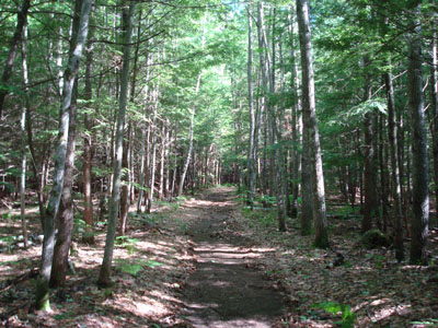
Looking up the trail to Peary Mountain
Route: Unknown trail, (Peary Mountain South Peak), herd path, (Peary Mountain), herd path, (Peary Mountain South Peak), Unknown trail
After having abused my knee coming down Wildcat D the day before, I decided I wanted to do something a bit more gentle. Not wanting to deal with ticks (Ossipees) or psycho skeeters (eastern Sandwich Range), I decided to try out Peary Mountain. I had been interested in hiking this one for a good year or so and, upon recently acquiring the AMC Maine guide, had enough information to hike it.
I at first drove by the trailhead, as I had read a description online saying that the bridge I was looking for was sketchy enough that I might think twice driving over it. To me, it seemed more like a glorified culvert, but I digress.
The first part of the logging road/trail was, well, a logging operation. Just beyond the landing, I found things a bit confusing, as there were a few forks in the road/trail. Bearing right at each of the two forks (and then crossing culverts) worked.
The skeeters were a bit pesky down low, even with DEET. As I reached the col after a fairly gradual ascent, they suddenly weren't much of an issue anymore. Though I didn't see a chimney or anything resembling one (apparently that was a landmark in knowing when to turn off the road/path), I saw some cairns directing me to the left, across another logging road, and up the hill.
Very quickly, I was at the top of the south peak of Peary Mountain. I found it to be somewhat similar to Jockey Cap in terms of the open rock face. The views from this peak were great, looking at the eastern White Mountains, as well as looking through some trees into Maine.
Though I had read it was a bit of a bushwack to get to the true summit, I found the herd path of sorts was as well marked and travelled as the trail to the south peak was - in fact, in addition to the occasion cairn, there was even some ribbon in the trees. The herd path starts with a short, somewhat steep dive off the south peak, then continues as a fairly gradual walk.
The views from the true summit, though not as strong as the south peak, were still nonetheless decent, looking at Pleasant Mountain and some of Evans Notch.
All in all, not a bad hike. Not as fun as nearby Burnt Meadow or Mt. Cutler, but still pretty good considering the views.
| Hike Ratings |
|
Getting To Trailhead: |
Easy |
| Destination: |
Peary Mountain (South Peak) |
|
Length: |
Easy |
|
Steepness: |
Moderate |
|
Navigation: |
Moderate |
|
Views: |
Excellent |
|
Crowds: |
Minimal |
| Destination: |
Peary Mountain |
|
Length: |
Moderate |
|
Steepness: |
Moderate |
|
Navigation: |
Moderate |
|
Views: |
Excellent |
|
Crowds: |
Minimal |
|
| Hike Stats |
|
Date Hiked: |
Thursday, June 19, 2008 |
| Hike Commenced: |
4:15 PM |
| Parking Elevation: |
420' |
| Destination: |
Peary Mountain (South Peak) |
| Ascent Commenced: |
4:15 PM |
| Summit Reached: |
4:35 PM |
| Time Elapsed: |
00:20 |
| Trailhead Elevation: |
420' |
| Summit Elevation: |
910' |
| Vertical Gain: |
515' |
| Destination: |
Peary Mountain |
| Ascent Commenced: |
4:36 PM |
| Summit Reached: |
4:43 PM |
| Time Elapsed: |
00:07 |
| Trailhead Elevation: |
910' |
| Summit Elevation: |
958' |
| Vertical Gain: |
83' |
|
|
| Hike Ended: |
5:16 PM |
| Hike Time Elapsed: |
01:01 |
| Hike Vertical Gain: |
678' |
|
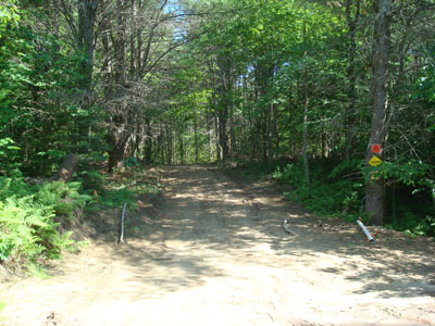
The trailhead for the trail to Peary Mountain on Farnsworth Road
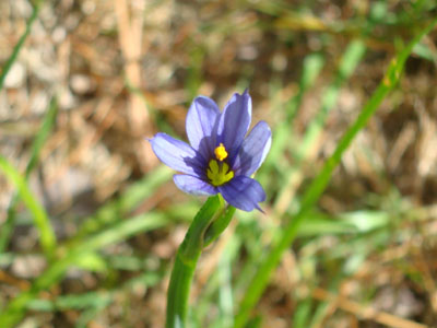
A wild flower near at the col
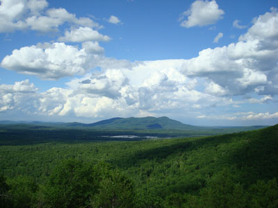
Looking at Pleasant Mountain from the Peary Mountain summit
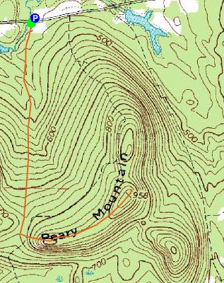

Directions to trailhead: Take Route 5 North from East Brownfield, then take a left onto Farnsworth Road. The trailhead and makeshift parking area will both be a few minutes down the road, just before a small bridge (no railings). The makeshift parking area is on the right, and the trailhead/logging road is on the left.
Back to Peary Mountain Profile
|