Home
States
Colorado
Connecticut
Maine
Massachusetts
New Hampshire
New York
Rhode Island
Utah
Vermont
View All
Lists
NE 4,000 Footers
NE 100 Highest
NH 4,000 Footers
NH 100 Highest
NH 52 With A View
NH Belknap Range
NH Ossipee 10
Links
Trail Conditions
Trip Log
Sunrises
Sunsets
About
|
Wiggin Mountain
Parsonsfield, ME
Trailheads, measurements, times, distances, and maps are all approximate and relative to the hike(s) as shown below.
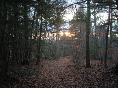
Looking down the woods road to Wiggin Mountain
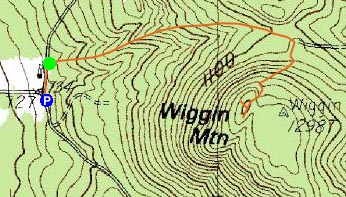
Route: Unknown woods road
The radar showed a small cell of rain showers passing through as I neared afternoon hike time. As I drove down to the Province Lake area, I was almost starting to second guess whether or not I should bother to hike, as there was a mixture of rain, wind, and snow! Nonetheless, by the time I reached the trailhead, the cell had moved on (and not rained this far south).
I parked just south of the fork in the road, and headed north along the dirt road to the woods road trailhead. The woods road was fairly straight and not overly steep for the first part of the ascent. Not long after passing a set of huts of some sort on the right hand side, I could see the height of land on the road (and a potential nice viewpoint of some sort up high on the left). Just prior to the height of land, I beared right onto a lesser used woods road, which then merged with a more eroded road. After a short steep ascent, it became gradual again, winding its way to what looks to be the highpoint on the topographic maps (though there is a recorded elevation to the east on the topographic map which is lower than the countor of the suspected highpoint).
Following a path a few dozen yards west, I soon reached a firepit and a great view to the west, ranging from the northern tip of Province Lake to Green Mountain. While this was a great view, it unfortunately didn't stretch far enough to the south to catch the sunset at this point in the fall. Since the sunset looked to be potentially amazing, I bushwhacked a bit south, hoping to find some sort of vista. Though I was unsuccessful, I did find a neat place with some less-obstructed views to the southwest, over an old stone wall.
On the way back, I checked out another knob to see if it was any higher than what I assumed to be the summit (it was not), then made my way back down the woods road.
While I was a bit let down by not being able to capture one of the best sunsets I've seen this fall, it was still nice to see at least something, as the expectations on the drive down were very low due to the weather at the time. I hope to check this one out again!
| Hike Ratings |
|
Getting To Trailhead: |
Easy |
| Destination: |
Wiggin Mountain |
|
Length: |
Moderate |
|
Steepness: |
Difficult |
|
Navigation: |
Moderate |
|
Views: |
Excellent |
|
Crowds: |
Minimal |
|
| Hike Stats |
|
Date Hiked: |
Monday, November 10, 2008 |
| Hike Commenced: |
3:50 PM |
| Parking Elevation: |
730' |
| Destination: |
Wiggin Mountain |
| Ascent Commenced: |
3:52 PM |
| Summit Reached: |
4:12 PM |
| Time Elapsed: |
00:20 |
| Trailhead Elevation: |
740' |
| Summit Elevation: |
1,305' |
| Vertical Gain: |
580' |
|
|
| Hike Ended: |
4:55 PM |
| Hike Time Elapsed: |
01:05 |
| Hike Vertical Gain: |
625' |
|
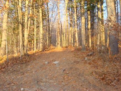
The trailhead (roadhead) of the trail (road) to Wiggin Mountain

Looking at the Ossipees, Sandwich Range, and Green Mountain from the Wiggin Mountain vista
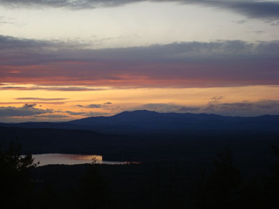
Sunset colors over Mt. Shaw as seen from the Wiggin Mountain vista

Directions to trailhead: From Route 25 east of Ossipee, take Route 153 south past South Effingham. As Province Lake comes into view, take a left onto Mountain Road (there will be a sign for Province Lake Country Club). Head straight down this road, through a four way intersection and to a fork in the road. There is some limited space along the road to park just beyond the right side of the fork. Walk back to the fork, this time going the left hand option up Lombard Hill Road. Immediately after passing a small field with a white shed (on the right), the woods road (trailhead) will be on the right.
Back to Wiggin Mountain Profile
|


