Home
States
Colorado
Connecticut
Maine
Massachusetts
New Hampshire
New York
Rhode Island
Utah
Vermont
View All
Lists
NE 4,000 Footers
NE 100 Highest
NH 4,000 Footers
NH 100 Highest
NH 52 With A View
NH Belknap Range
NH Ossipee 10
Links
Trail Conditions
Trip Log
Sunrises
Sunsets
About
|
Peppercorn Hill
Upton, MA
Trailheads, measurements, times, distances, and maps are all approximate and relative to the hike(s) as shown below.
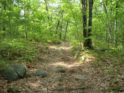
Looking up the Walleston Trail
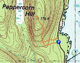
Route: Spur trail, Walleston Trail, (Peppercorn Hill), Walleston Trail, spur trail
For the last of the three small hikes in the region, I headed to Peppercorn Hill. After weaving through a bunch of roads due to some confusion in getting off 495, I eventually found South Road (and thusly the other roads) adjacent to the overpass.
Starting on Crockett Road, the mosquitoes were a bit pesky. Walking up the trail from the parking lot, I soon reached the Walleston Trail, which I took to the summit. In general, the trail was pretty much a fourwheeler road that never became particularly steep.
Just beyond the general vicinity of the highpoint (likely a boulder), I took a left onto a short side trail to a decent view ledge. While there wasn't too much to look at, it nonetheless was a rare peak-based view for this part of New England.
For the descent, I took a left off the Walleston Trail a bit sooner and followed a different spur trail down to a gate just beyond the trailhead.
| Hike Ratings |
|
Getting To Trailhead: |
Easy |
| Destination: |
Peppercorn Hill |
|
Length: |
Easy |
|
Steepness: |
Easy |
|
Navigation: |
Easy |
|
Views: |
Excellent |
|
Crowds: |
Minimal |
|
| Hike Stats |
|
Date Hiked: |
Saturday, May 22, 2010 |
| Hike Commenced: |
3:28 PM |
| Parking Elevation: |
355' |
| Destination: |
Peppercorn Hill |
| Ascent Commenced: |
3:28 PM |
| Summit Reached: |
3:35 PM |
| Time Elapsed: |
00:07 |
| Trailhead Elevation: |
355' |
| Summit Elevation: |
585' |
| Vertical Gain: |
235' |
|
|
| Hike Ended: |
3:48 PM |
| Hike Time Elapsed: |
00:20 |
| Hike Vertical Gain: |
245' |
|
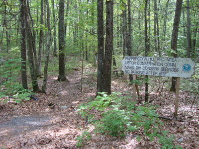
The Crockett Road trailhead
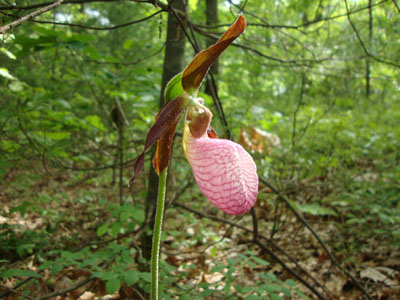
Lady slipper along the Walleston Trail
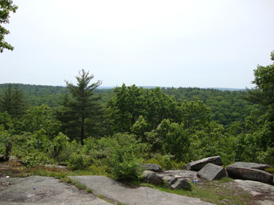
Looking west from the view ledge near the summit of Peppercorn Hill

Directions to trailhead: From West Main Street (Exit 21B on I-495 northbound), take a left onto South Street. After passing the many EMC buildings, take a right onto Camp Street. At a four way junction, take a right onto Crockett Road. The Peppercorn Hill Rec Area small dirt parking lot will be located on the left in a few minutes.
Back to Peppercorn Hill Profile
|

