Home
States
Colorado
Connecticut
Maine
Massachusetts
New Hampshire
New York
Rhode Island
Utah
Vermont
View All
Lists
NE 4,000 Footers
NE 100 Highest
NH 4,000 Footers
NH 100 Highest
NH 52 With A View
NH Belknap Range
NH Ossipee 10
Links
Trail Conditions
Trip Log
Sunrises
Sunsets
About
|
Barron Mountain
Thorton, NH
Trailheads, measurements, times, distances, and maps are all approximate and relative to the hike(s) as shown below.
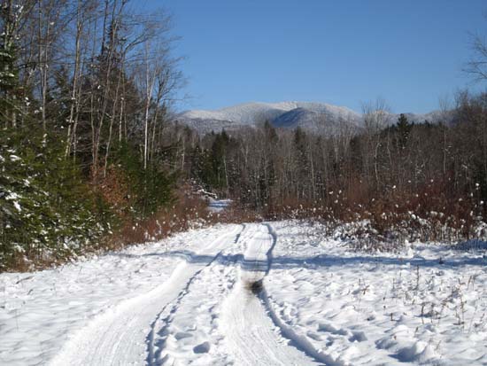
A logging road on the way to Barron Mountain
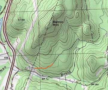
Route: Sellingham Hill Road, logging roads, bushwhack
Started off at the high tension power lines on Sellingham Road, continuing up the road on foot, going straight at the top of the road (where a driveway bears left) onto a logging road. At the first junction, I beared left, then beared left again and headed uphill on a slightly more overgrown logging road. Up to this point, the snow was generally 6-8" deep. I wore snowshoes for the ascent, but barebooted the descent because they were frankly just getting in the way.
Eventually running out of logging road near the bottom of the steeper terrain, I bushwhacked up to the ridge. The snow was closer to 3" deep in the south facing areas. The ridge was slower going than expected, due to a lot of large blowdown. I was generally able to weave my way around it (much faster on the descent, as I could just follow my tracks). Quite a few nice directional views prior to reaching the highpoint, some of which would still be visible with leaves on the trees. Occasionally noted some cairns and flagging tape, but didn't see any evidence of a maintained trail otherwise. A few possible highpoints on the wooded, viewless summit.
| Hike Ratings |
|
Getting To Trailhead: |
Easy |
| Destination: |
Barron Mountain |
|
Length: |
Moderate |
|
Steepness: |
Difficult |
|
Navigation: |
Difficult |
|
Views: |
Excellent |
|
Crowds: |
Minimal |
|
| Hike Stats |
|
Date Hiked: |
Saturday, November 29, 2014 |
| Parking Elevation: |
760' |
| Destination: |
Barron Mountain |
| Time Elapsed: |
00:56 |
| Trailhead Elevation: |
880' |
| Summit Elevation: |
1,660' |
| Vertical Gain: |
830' |
|
|
| Hike Time Elapsed: |
01:50 |
| Hike Vertical Gain: |
910' |
|
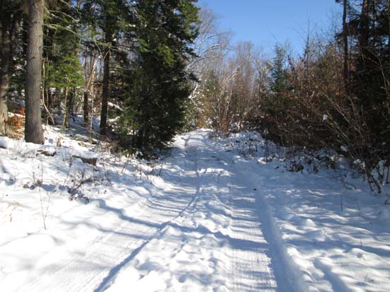
The start of the unmaintained extension of Sellingham Hill Road
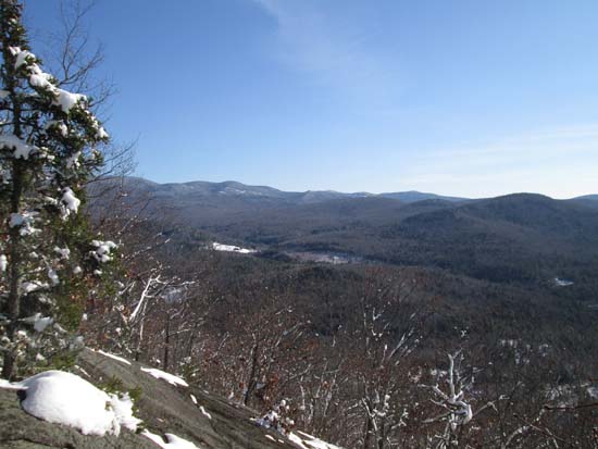
Looking southeast at the southern ridge leading to Mt. Tecumseh

Directions to trailhead: Take Route 175 south from Woodstock, under I-93, then take a left onto Thornton Gore Road, then take a left onto Sellingham Hill Road. There may be room to park under the high tension power lines.
Back to Barron Mountain Profile
|

