Home
States
Colorado
Connecticut
Maine
Massachusetts
New Hampshire
New York
Rhode Island
Utah
Vermont
View All
Lists
NE 4,000 Footers
NE 100 Highest
NH 4,000 Footers
NH 100 Highest
NH 52 With A View
NH Belknap Range
NH Ossipee 10
Links
Trail Conditions
Trip Log
Sunrises
Sunsets
About
|
Bayle Mountain
Ossipee, NH
Trailheads, measurements, times, distances, and maps are all approximate and relative to the hike(s) as shown below.
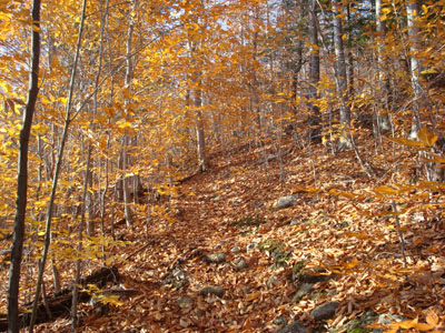
Looking up the trail to Bayle Mountain
Route: Unknown snowmobile trail, red blazed trail, (Bayle Mountain), red blazed trail, unknown snowmobile trail
Since the mostly sunny day was still looking rather cloudy up north, I decided to stay local and head to Bayle Mountain. While I prefer the scenery from the western branch of the snowmobile trail, I decided to take the slightly shorter east branch to the trailhead.
The lower portion of the trail still had some late fall foliage, making things rather colorful. The trail, despite recent rains, was fairly dry.
The views from the summit were tremendous - though there were some clouds in the sky, the views seemed to be perhaps the best I've ever experienced from Bayle - Moose Mountain to the south and the mountains of Maine to the east were very clearly seen and appeared to be closer than they really are.
| Hike Ratings |
|
Getting To Trailhead: |
Moderate |
| Destination: |
Bayle Mountain |
|
Length: |
Moderate |
|
Steepness: |
Difficult |
|
Navigation: |
Easy |
|
Views: |
Excellent |
|
Crowds: |
Minimal |
|
| Hike Stats |
|
Date Hiked: |
Thursday, October 30, 2008 |
| Hike Commenced: |
3:47 PM |
| Parking Elevation: |
1,040' |
| Destination: |
Bayle Mountain |
| Ascent Commenced: |
3:52 PM |
| Summit Reached: |
4:15 PM |
| Time Elapsed: |
00:23 |
| Trailhead Elevation: |
1,100' |
| Summit Elevation: |
1,853' |
| Vertical Gain: |
763' |
|
|
| Hike Ended: |
5:01 PM |
| Hike Time Elapsed: |
01:14 |
| Hike Vertical Gain: |
873' |
|
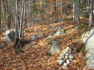
The trailhead to the trail to the Bayle Mountain summit
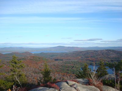
Looking at Green Mountain from the Bayle Mountain summit
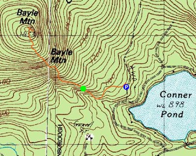

Directions to trailhead: From Route 16 South in West Ossipee, take a right onto Pine Hill Road. At the end of Pine Hill Road, take a right onto Ossipee Mountain Road. 2015 update: There is now a parking area off Marble Road, past Connor Pond.
Back to Bayle Mountain Profile
|

