Home
States
Colorado
Connecticut
Maine
Massachusetts
New Hampshire
New York
Rhode Island
Utah
Vermont
View All
Lists
NE 4,000 Footers
NE 100 Highest
NH 4,000 Footers
NH 100 Highest
NH 52 With A View
NH Belknap Range
NH Ossipee 10
Links
Trail Conditions
Trip Log
Sunrises
Sunsets
About
|
Boy Mountain
Jefferson, NH
Trailheads, measurements, times, distances, and maps are all approximate and relative to the hike(s) as shown below.

Looking up the Bois Mountain Trail
Route: Bois Mountain Trail
After hiking Mt. Success, we headed west to find Boy Mountain.
Parking adjacent to a spring, we walked west on US 2, then headed up the Boismont Drive, bearing right at a split. The trail proper started behind a house at a small shed with a sign.
Intially a steep field, the trail veered off to the right quickly and then joined a series of old logging roads, before becoming more trail-like for the main portion of the ascent. Though less than a mile in length, it was nonetheless a steady climb.
Reaching the end of the trail, there were excellent views to the south - it would perhaps be a great viewpoint if the Presidentials weren't in the clouds. Nonetheless, it was a nice view even with the subpar weather. After touching a potential highpoint off trail, we returned the way we ascended, taking a different private way between the house and barn back to US 2.
| Hike Ratings |
|
Getting To Trailhead: |
Moderate |
| Destination: |
Boy Mountain |
|
Length: |
Easy |
|
Steepness: |
Moderate |
|
Navigation: |
Moderate |
|
Views: |
Excellent |
|
Crowds: |
Minimal |
|
| Hike Stats |
|
Date Hiked: |
Sunday, October 17, 2010 |
| Hike Commenced: |
2:37 PM |
| Parking Elevation: |
1,560' |
| Destination: |
Boy Mountain |
| Ascent Commenced: |
2:40 PM |
| Summit Reached: |
3:00 PM |
| Time Elapsed: |
00:20 |
| Trailhead Elevation: |
1,600' |
| Summit Elevation: |
2,234' |
| Vertical Gain: |
634' |
|
|
| Hike Vertical Gain: |
674' |
|
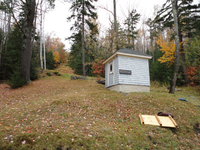
The Bois Mountain Trail trailhead
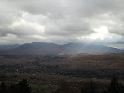
Looking at the Darmouth Range from near the Boy Mountain summit
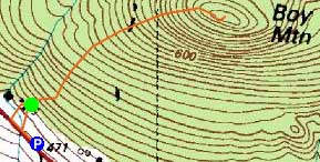

Directions to trailhead: Take US 2 West from Gorham into Jefferson. Shortly after passing Carters Cut Road on the left, there is an expanded dirt shoulder and spring on the right. Park there, then proceed on foot west to Boismont Drive. Proceed on foot up the driveway, bearing right. The Bois Mountain Trail starts behind the house and barn on the side of a steep field, adjacent to a small shed.
Back to Boy Mountain Profile
|

