Home
States
Colorado
Connecticut
Maine
Massachusetts
New Hampshire
New York
Rhode Island
Utah
Vermont
View All
Lists
NE 4,000 Footers
NE 100 Highest
NH 4,000 Footers
NH 100 Highest
NH 52 With A View
NH Belknap Range
NH Ossipee 10
Links
Trail Conditions
Trip Log
Sunrises
Sunsets
About
|
Hersey Mountain
New Hampton, NH, Sanbornton, NH
Trailheads, measurements, times, distances, and maps are all approximate and relative to the hike(s) as shown below.
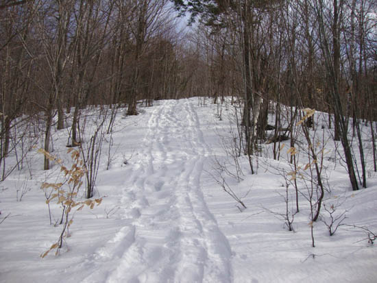
Looking up the logging road on the way to Hersey Mountain
Route: Carter Mountain Road, logging road, Carter Mountain Road, logging road, unknown trail, (Hersey Mountain), unknown trail, logging road, Carter Mountain Road
While I had been looking at Hersey Mountain for years, the closest I had been to it was nearby Burleigh Mountain. With weather and conditions confining me to the lakes region, and with the snowpack fairly firm, I opted to give it a go.
I started on the roadwalk on snowshoes, continuing straight at snowmobile junction D. I then passed a logging landing at the blue blazed corner of the George Duncan State Forest, noting snowshoe tracks heading into the landing. I continued uphill a bit, noting an open area downhill toward Burleigh Mountain. Following a road down to that marshy area, which I had planned to base my bushwhacking bearing on, I decided to head back up to the logging landing and follow the snowshoe tracks up the side of Hersey Mountain.
Returning to the logging landing, I headed uphill from it on a logging road, reaching another landing a few minutes later. At this landing, I headed toward the mountain, following a lesser logging road. This logging road eventually faded away, however there was still a somewhat obvious path heading uphill, curving around a few ledgy areas.
Eventually reaching the summit area, I made my way around the peak, stopping at multiple viewpoints - strong views to the south (Ragged, Kearsarge, Monadnock), southeeast (Belknaps), east, northeast, and north (White Mountains). I didn't find an obvious western viewpoint, but perhaps some further investigating downhill could find something.
The descent went fairly smoothly, as I was able to follow my snowshoe tracks on autopilot.
| Hike Ratings |
|
Getting To Trailhead: |
Moderate |
| Destination: |
Hersey Mountain |
|
Length: |
Moderate |
|
Steepness: |
Difficult |
|
Navigation: |
Difficult |
|
Views: |
Excellent |
|
Crowds: |
Minimal |
|
| Hike Stats |
|
Date Hiked: |
Monday, March 28, 2011 |
| Parking Elevation: |
1,030' |
| Time to Trailhead: |
00:30 |
| Destination: |
Hersey Mountain |
| Time Elapsed: |
00:33 |
| Trailhead Elevation: |
1,110' |
| Summit Elevation: |
2,001' |
| Vertical Gain: |
911' |
|
|
| Hike Time Elapsed: |
01:58 |
| Hike Vertical Gain: |
1,191' |
|
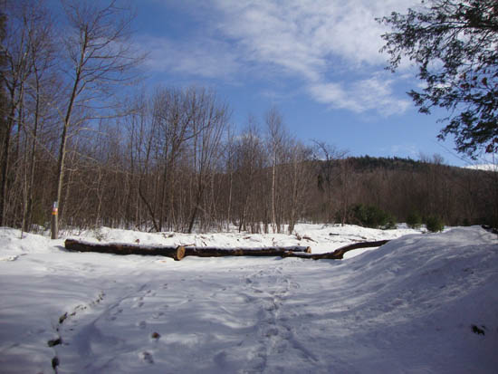
The logging landing at the corner of George Duncan State Forest
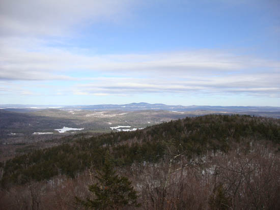
Looking at the Belknaps from Hersey Mountain
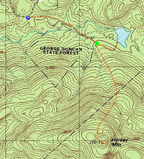

Directions to trailhead: From I-93 in New Hampton, take Route 104 West. Take a left onto Route 132. Shortly thereafter, take a right onto Old Bristol Road. Awhile down this road, take a left onto Carter Mountain Road. There will eventually be a Class IV road sign, with adjacent gate. In winter, there is limited plowed parking to the right of this gate. One can continue down the road on foot, passing straight through snowmobile junction D. Shortly thereafter, there is a logging landing on the right (at the border of George Duncan State Forest). A quasi trail heads uphill on an increasingly faint logging road from this landing (ignore a chained road on the left at the lower landing).
Back to Hersey Mountain Profile
|

