Home
States
Colorado
Connecticut
Maine
Massachusetts
New Hampshire
New York
Rhode Island
Utah
Vermont
View All
Lists
NE 4,000 Footers
NE 100 Highest
NH 4,000 Footers
NH 100 Highest
NH 52 With A View
NH Belknap Range
NH Ossipee 10
Links
Trail Conditions
Trip Log
Sunrises
Sunsets
About
|
Kinsman Mountain (North Peak), Kinsman Mountain (South Peak), Northeast Cannonball, Cannon Mountain, Mittersill Peak
Easton, NH, Lincoln, NH, Franconia, NH
Trailheads, measurements, times, distances, and maps are all approximate and relative to the hike(s) as shown below.
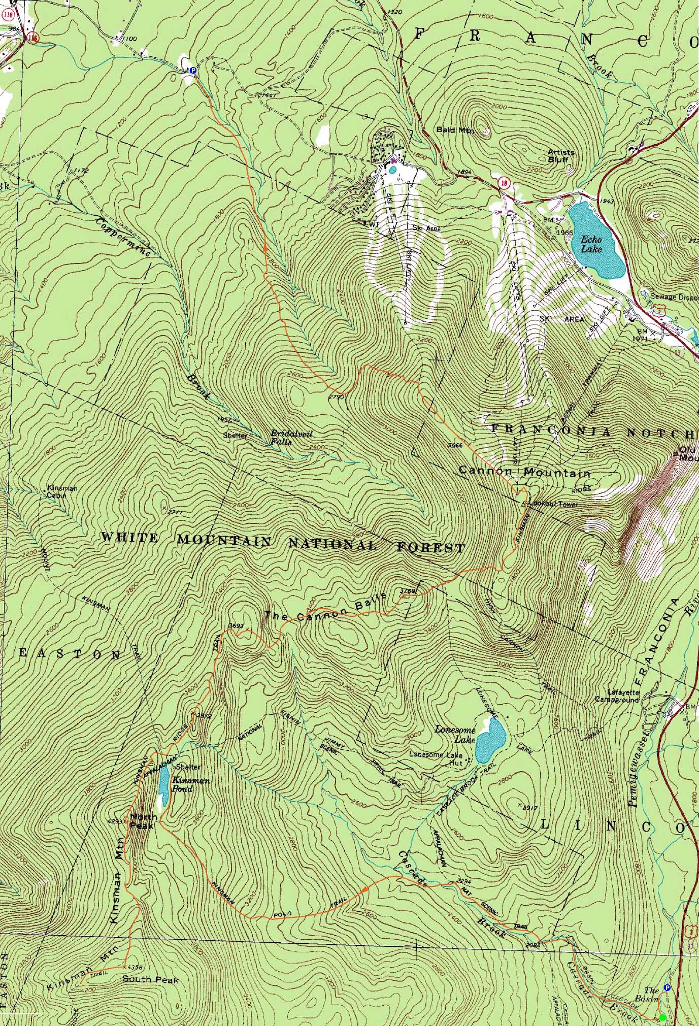
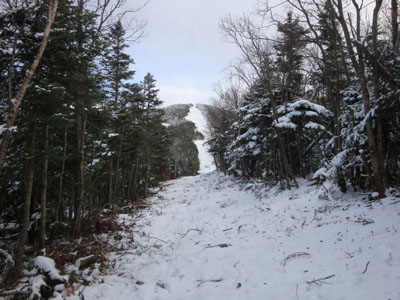
Looking up the rough Kinsman Pond Trail
Route: Basin Trails, Basin Cascades Trail, Cascade Brook Trail, Kinsman Pond Trail, Kinsman Ridge Trail, (North Kinsman), Kinsman Ridge Trail, (South Kinsman), Kinsman Ridge Trail, (North Kinsman Trail), Kinsman Ridge Trail, (Northeast Cannonball), Kinsman Ridge Trail, (Cannon Mountain), spur trail to tramway station, Taft Trail, (Mittersill Peak), Taft Trail, Tucker Brook Trail
Though the weather forecast looked fair at best, the skies were clear as we spotted a vehicle on the western end of the Kinsman Ridge and approached the east side. After guess the correct sequence of turns to get to the Basin-Cascades Trail (head toward the bike path, then into the Basin, then downhill - trailhead on right), we were soon surprised by the nice scenery offered. By the looks of it, this place must be packed on a nice summer day.
Reaching the Cascade Brook Trail, we soon reached a point of confusion at a bridge crossing - there was a temporary Appalachian Trail sign pointing upstream into the woods, contrary to the bridge crossing. After twice checking the map, we decided to go with our instincts rather than the sign (which would prove to be the correct decision).
Almost immediately after reaching the Kinsman Pond Trail junction, we were faced with a tricky water crossing - the rocks were covered in a glaze. A secret for this time of year is that submerged rocks aren't icy - so it was a question of finding a place to crossing on rocks no more than an inch or two under water.
The trail started off quite nicely - other than the occasional scramble, it was never overly steep. An occasional cascade off to the side provided some nice scenery. After climbing awhile, though, things became vexing - the trail essentially became a brook bed for the balance of the ascent to the pond. Not much fun!
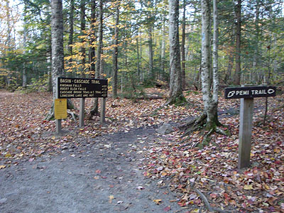
Kinsman Pond was quite a sight, though - frozen over with frosted trees and blue sky.
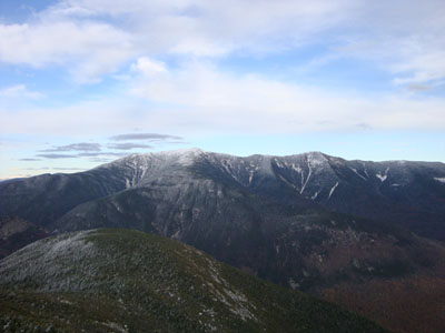
Climbing up some tricky icy scrambles to North Kinsman, we were greeted with some excellent late-foliage views - some slight color remaining in the valley along with snow covered peaks.
The views from South Kinsman were also quite nice - for the first time in a few visits, I had decent visibility into Vermont. After a lunch break, we turned around, re-climbed North Kinsman, and headed over the Cannonballs.
Despite being only 2.4 miles or so in length, the Cannonballs section of the Kinsman Ridge Trail seems to go on forever - quite a few ups and downs, a few nasty (icy) scrambles, and not much in way of views until reaching the northeast peak. Of course, there was still more climbing to do after this.
The climb up Cannon was relentless and a bit tricky, thanks to the ice. Even with the Microspikes on, it was still a bit tough. What a nasty, eroded trail.
Reaching the summit tower, we had excellent views once again (though not quite as much blue sky as earlier in the day). I think made a beeline to the tram station, so I could grab a hot chocolate and whatever packaged food they still had for sale (the grill was closed for the day, unfortunately). After a nice snack break, it was time to head down the Taft trail to Mittersill Peak.
The Taft Slalom Trail was covered in a few inches of powder, but was still not overly slippery. Nonetheless, the constant steepness put a lot of pressure on my recently injured knee (a few days prior), so I was limping an increasing amount as we dropped.
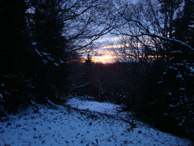
The views from Mittersill Peak were also quite good - sunset colors were even starting to show in the horizon. Not to far past the peak, we took a right onto the Tuckerbrook Trail. Though covered with short spruce, the trail looks skiable with a few feet of snow. While there are some twists and turns and moderate chutes, there are also a few long flat sections that might make it a bit vexing for skiers with their heels locked in.
Dropping lower, we soon left the snow and were into fall foliage again. Reaching the more gradual portions of the trail, the pressure on my injured knee subsided a bit, allowing for me to get closer to a normal pace again. Though we ended up on the trail awhile after sunset, we were able to make it to the small parking area without needing headlamps.
| Hike Ratings |
|
Getting To Trailhead: |
Easy |
| Destination: |
Kinsman Mountain (North Peak) |
|
Length: |
Moderate |
|
Steepness: |
Very Difficult |
|
Navigation: |
Moderate |
|
Views: |
Excellent |
|
Crowds: |
Minimal |
| Destination: |
Kinsman Mountain (South Peak) |
|
Length: |
Moderate |
|
Steepness: |
Difficult |
|
Navigation: |
Easy |
|
Views: |
Excellent |
|
Crowds: |
Minimal |
| Destination: |
Kinsman Mountain (North Peak) |
|
Length: |
Moderate |
|
Steepness: |
Difficult |
|
Navigation: |
Moderate |
|
Views: |
Excellent |
|
Crowds: |
Heavy |
| Destination: |
Northeast Cannonball |
|
Length: |
Moderate |
|
Steepness: |
Very Difficult |
|
Navigation: |
Easy |
|
Views: |
Excellent |
|
Crowds: |
Moderate |
| Destination: |
Cannon Mountain |
|
Length: |
Difficult |
|
Steepness: |
Very Difficult |
|
Navigation: |
Easy |
|
Views: |
Excellent |
|
Crowds: |
Heavy |
| Destination: |
Mittersill Peak |
|
Length: |
Difficult |
|
Steepness: |
Difficult |
|
Navigation: |
Easy |
|
Views: |
Excellent |
|
Crowds: |
Minimal |
|
| Hike Stats |
|
Date Hiked: |
Saturday, October 17, 2009 |
| Hike Commenced: |
7:45 AM |
| Parking Elevation: |
1,580' |
| Destination: |
Kinsman Mountain (North Peak) |
| Ascent Commenced: |
7:51 AM |
| Summit Reached: |
10:58 AM |
| Time Elapsed: |
03:07 |
| Trailhead Elevation: |
1,520' |
| Summit Elevation: |
4,293' |
| Vertical Gain: |
2,813' |
| Destination: |
Kinsman Mountain (South Peak) |
| Ascent Commenced: |
11:10 AM |
| Summit Reached: |
11:48 AM |
| Time Elapsed: |
00:38 |
| Trailhead Elevation: |
4,293' |
| Summit Elevation: |
4,358' |
| Distance: |
.9 mile |
| Vertical Gain: |
373' |
| Destination: |
Kinsman Mountain (North Peak) |
| Ascent Commenced: |
12:24 PM |
| Summit Reached: |
1:03 PM |
| Time Elapsed: |
00:39 |
| Trailhead Elevation: |
4,358' |
| Summit Elevation: |
4,293' |
| Distance: |
.9 mile |
| Vertical Gain: |
308' |
| Destination: |
Northeast Cannonball |
| Ascent Commenced: |
12:24 PM |
| Summit Reached: |
3:12 PM |
| Time Elapsed: |
02:48 |
| Trailhead Elevation: |
4,293' |
| Summit Elevation: |
3,769' |
| Vertical Gain: |
991' |
| Destination: |
Cannon Mountain |
| Ascent Commenced: |
3:16 PM |
| Summit Reached: |
4:10 PM |
| Time Elapsed: |
00:54 |
| Trailhead Elevation: |
3,769' |
| Summit Elevation: |
4,100' |
| Vertical Gain: |
735' |
| Destination: |
Mittersill Peak |
| Ascent Commenced: |
4:40 PM |
| Summit Reached: |
5:03 PM |
| Time Elapsed: |
00:23 |
| Trailhead Elevation: |
4,100' |
| Summit Elevation: |
3,617' |
| Vertical Gain: |
122' |
|
|
| Hike Ended: |
6:38 PM |
| Hike Time Elapsed: |
10:53 |
| Hike Vertical Gain: |
5,442' |
|
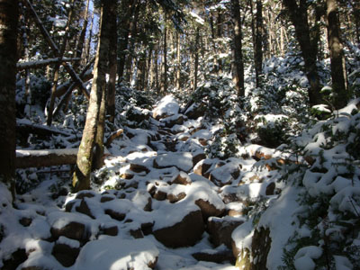
The Basin Cascade Trail trailhead in the Basin
A frozen Kinsman Pond

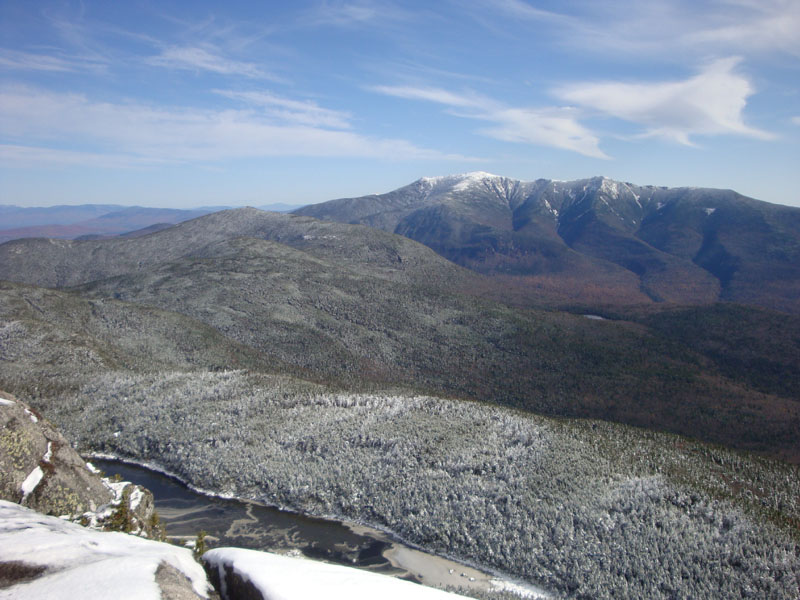
Kinsman Pond, Cannon Mountain, and the Franconia Ridge as seen from a ledge near the summit of Kinsman Mountain's North Peak
The Kinsman Ridge Trail between the Kinsmans
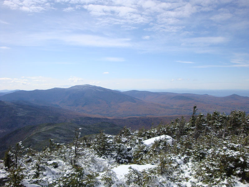
Mt. Moosilauke as seen from near the summit of Kinsman Mountain's South Peak
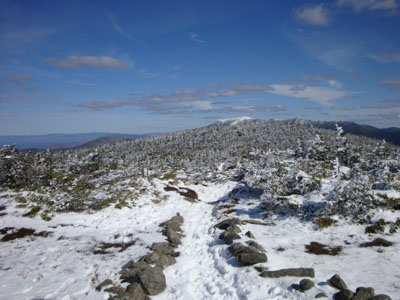
The Kinsman Ridge Trail between North Kinsman and Northeast Cannonball

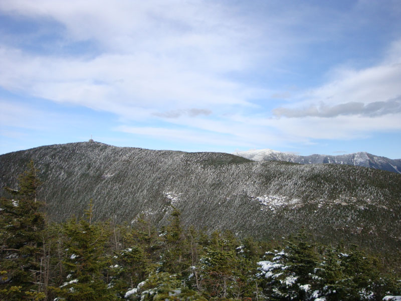
Cannon Mountain as seen from Northeast Cannonball
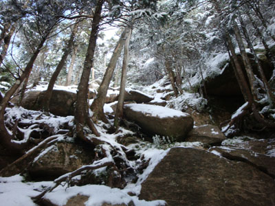
The nasty, eroded ascent of Cannon Mountain on the Kinsman Ridge Trail
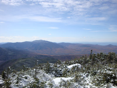
The Franconia Ridge as seen from the Cannon Mountain observation tower
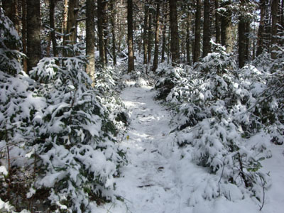
The Taft Trail between Cannon Mountain and Mittersill Peak
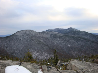
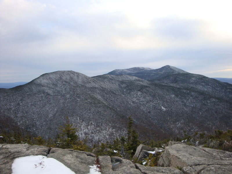
Northeast Cannon Ball and the Kinsmans as seen from Mittersill Peak
The Tucker Brook Trail
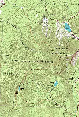

Directions to trailhead: To get to the Basin Cascades Trail, take I-93 south from Franconia to the Basin exit and parking lot. Follow the Basin signs, heading downhill through the various water features. The Basin Cascades Trail trailhead will eventually be on the right. To get to the Tucker Brook Trail, take I-93 North to Route 18, then take Route 18 northwest past the Cannon Peabody Slopes and Mittersill entrances. A few minutes after, take a left off Route 18 onto Wells Road. A few minutes after, at a sharp right turn on Wells Road, take a left turn onto the dirt Tucker Brook Road (unsigned as of fall 2009, except for a Dead End warning). There is a small parking area at the end of this road - the Tucker Brook Trail enters on the right.
Back to Kinsman Mountain (North Peak) Profile
Back to Kinsman Mountain (South Peak) Profile
Back to Northeast Cannonball Profile
Back to Cannon Mountain Profile
Back to Mittersill Peak Profile
|