Home
States
Colorado
Connecticut
Maine
Massachusetts
New Hampshire
New York
Rhode Island
Utah
Vermont
View All
Lists
NE 4,000 Footers
NE 100 Highest
NH 4,000 Footers
NH 100 Highest
NH 52 With A View
NH Belknap Range
NH Ossipee 10
Links
Trail Conditions
Trip Log
Sunrises
Sunsets
About
|
Mittersill Peak, Cannon Mountain
Franconia, NH
Trailheads, measurements, times, distances, and maps are all approximate and relative to the hike(s) as shown below.
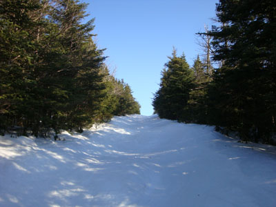
Looking up the Taft Trail on the way up Mittersill Peak
Route: Taft Cut Off, Taft Trail, (Mittersill), Taft Trail, spur trail, (Cannon Mountain), spur trail, Taft Trail, (Mittersill), Taft Trail, Taft Cut Off
While the weather wasn't looking great for the first part of the day, things started to clear out nicely in the afternoon. Thus, I decided to head up and do a late afternoon hike up to Cannon.
After parking in a very muddy lot at the bottom of the old Mittersill ski area, I ascended the Taft Cut Off on snowshoes, soon reaching the top of the ski area and then the top of the peak. Of note was the changes in the past few months - a ski patrol dog house had been added to the peak and signage had been updated - part of the incorporation of Mittersill into the Cannon Mountain ski area.
After snowshoeing up the far edge of the freshly groomed Taft Trail (as to not mess up the corduroy), I soon reached the summit. Though it was a very nice day with good views, I didn't spend much time on the observation deck, as large chunks of ice were falling off the communications tower - I wasn't looking to get knocked out while solo hiking late in the day!
I had a bit of fun while descending through the old ski area, as I hopped around the moguls as if I were skiing. Good exercise!
| Hike Ratings |
|
Getting To Trailhead: |
Easy |
| Destination: |
Mittersill Peak |
|
Length: |
Moderate |
|
Steepness: |
Difficult |
|
Navigation: |
Moderate |
|
Views: |
Excellent |
|
Crowds: |
Minimal |
| Destination: |
Cannon Mountain |
|
Length: |
Moderate |
|
Steepness: |
Difficult |
|
Navigation: |
Easy |
|
Views: |
Excellent |
|
Crowds: |
Minimal |
|
| Hike Stats |
|
Date Hiked: |
Friday, March 27, 2009 |
| Hike Commenced: |
4:21 PM |
| Parking Elevation: |
1,860' |
| Destination: |
Mittersill Peak |
| Ascent Commenced: |
4:22 PM |
| Summit Reached: |
5:15 PM |
| Time Elapsed: |
00:53 |
| Trailhead Elevation: |
1,870' |
| Summit Elevation: |
3,617' |
| Vertical Gain: |
1,747' |
| Destination: |
Cannon Mountain |
| Ascent Commenced: |
5:17 PM |
| Summit Reached: |
5:35 PM |
| Time Elapsed: |
00:18 |
| Trailhead Elevation: |
3,617' |
| Summit Elevation: |
4,100' |
| Vertical Gain: |
605' |
|
|
| Hike Ended: |
6:45 PM |
| Hike Time Elapsed: |
02:24 |
| Hike Vertical Gain: |
2,449' |
|
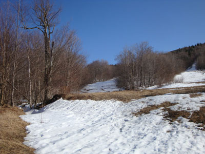
Looking up the old Mittersill ski area
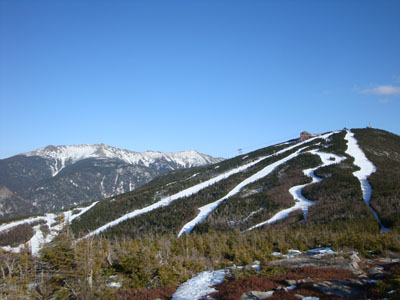
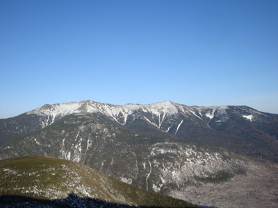
Looking at the Franconia Ridge and Cannon Mountain from the top of Mittersill Peak
Looking down the Taft Trail on the way to Cannon Mountain
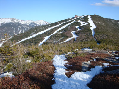
Looking at the Franconia Ridge from the Cannon Mountain observation tower
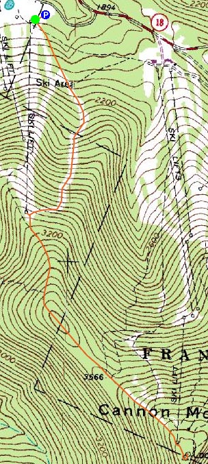

Directions to trailhead: Take I-93 North to the Cannon Mountain Peabody Slopes exit. Continue past the Cannon entrance, taking a left at the Mittersill sign. There are multiple parking areas on the left a fraction of a mile down this road. Looking uphill adjacent to the old double chairlift, the Taft Cut Off Trail is the furthest to the left.
Back to Mittersill Peak Profile
Back to Cannon Mountain Profile
|


