Home
States
Colorado
Connecticut
Maine
Massachusetts
New Hampshire
New York
Rhode Island
Utah
Vermont
View All
Lists
NE 4,000 Footers
NE 100 Highest
NH 4,000 Footers
NH 100 Highest
NH 52 With A View
NH Belknap Range
NH Ossipee 10
Links
Trail Conditions
Trip Log
Sunrises
Sunsets
About
|
Mt. Carrigain
Livermore, NH
Trailheads, measurements, times, distances, and maps are all approximate and relative to the hike(s) as shown below.
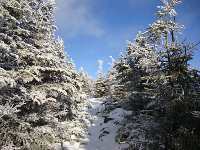
Looking up the Signal Ridge Trail
Route: Signal Ridge Trail
Having seen on the WMNF web site that Gale River Road and Haystack Road were still open, my plan was to take the day and hike the Twins and/or Galehead. After getting up at a gosh-awful hour and driving to Twin Mountain, I was a bit perturbed to see both roads gated. Thank you, Almighty Federal Government. Sawyer River Road was still open, so I decided to hike Carrigain in the morning. It was fitting to see the bridge removal warning sign at the trailhead had been defaced - "of the govt, by the govt, for the govt (They don't listen to the people!)."
I was able to bareboot over the flats and up the first two switchbacks of the Signal Ridge Trail, prior to putting on Microspikes. Reaching the summit, my snowshoes never ended up leaving my pack - there was perhaps less snow on Mt. Carrigain than in Crawford Notch. The views were rather hazy to the south, west, and east, as yet another rain storm was inching its way into the region. Nonetheless, the views to the snow-covered Presidentials were quite strong.
For the descent, I took my time and tried to clean blowdowns of various vintages. Weatherwise, this felt more like early October than December.
| Hike Ratings |
|
Getting To Trailhead: |
Easy |
| Destination: |
Mt. Carrigain |
|
Length: |
Difficult |
|
Steepness: |
Difficult |
|
Navigation: |
Moderate |
|
Views: |
Excellent |
|
Crowds: |
Minimal |
|
| Hike Stats |
|
Date Hiked: |
Wednesday, December 2, 2009 |
| Hike Commenced: |
7:08 AM |
| Parking Elevation: |
1,370' |
| Destination: |
Mt. Carrigain |
| Ascent Commenced: |
7:09 AM |
| Summit Reached: |
9:26 AM |
| Time Elapsed: |
02:17 |
| Trailhead Elevation: |
1,370' |
| Summit Elevation: |
4,700' |
| Distance: |
5 miles |
| Vertical Gain: |
3,430' |
|
|
| Hike Ended: |
12:07 PM |
| Hike Time Elapsed: |
04:59 |
| Hike Distance: |
10 miles |
| Hike Vertical Gain: |
3,540' |
|
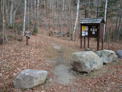
Signal Ridge Trail trailhead on Sawyer River Road
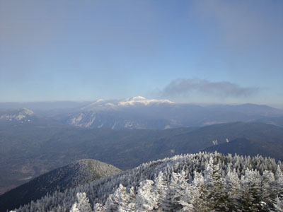
Looking at Mt. Washington from the Mt. Carrigain summit lookout tower

Directions to trailhead: Take Route 302 West from Bartlett to Sawyer River Road. WMNF fee parking lot is a few minutes up the dirt road on the left. Trailhead is across the road.
Back to Mt. Carrigain Profile
|


