Home
States
Colorado
Connecticut
Maine
Massachusetts
New Hampshire
New York
Rhode Island
Utah
Vermont
View All
Lists
NE 4,000 Footers
NE 100 Highest
NH 4,000 Footers
NH 100 Highest
NH 52 With A View
NH Belknap Range
NH Ossipee 10
Links
Trail Conditions
Trip Log
Sunrises
Sunsets
About
|
Mt. Carrigain
Livermore, NH
Trailheads, measurements, times, distances, and maps are all approximate and relative to the hike(s) as shown below.
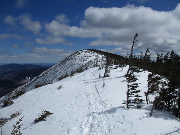
The Signal Ridge Trail
Route: Sawyer River Road, Signal Ridge Trail, bushwhack, (Mt. Carrigain), Signal Ridge Trail, Sawyer River Road
Decent weather for the last weekend day of the winter.
Sawyer River Road was well tracked out by snowmobiles (didn't encounter any at 8AM) with lots of base.
Snowpack had finally set up after the thaw. With temperatures below freezing, the footbed was firm enough that folks could Microspike without postholing. There was a lot of carnage from barebooting parasitic postholers prior to the freeze, including some extremely deep holes (many up to the handles of my poles). The snowpack is really deep in places, so not bringing snowshoes can be seen as negligent...if the snowpack softens in the sun, or if you lose the trail from drifting, you're in deep trouble without flotation, miles from the nearest road and out of cell reception.
I wore snowshoes from car to car and had no issues. Others wore them for the ascent to take advantage of the heel lifts. All but one hiker today at least carried snowshoes (about half wore them). Off trail, if wearing snowshoes, you can go anywhere without sinking; ideal bushwhacking conditions right now.
Lower elevations are frozen granular and loose granular, while the upper elevations had an inch or so of overnight powder. The current tracked out route takes the old route from the old Carrigain Notch junction. There are also two tracked out routes in lower rerouted switchbacks along the brook, and there are two routes just prior to the summit (neither on the actual trail).
Some wind early, but nothing too bad on the ridge or from the tower. Chilly when standing still up high, but relatively mild down low.
| Hike Ratings |
|
Getting To Trailhead: |
Difficult |
| Destination: |
Mt. Carrigain |
|
Length: |
Difficult |
|
Steepness: |
Difficult |
|
Navigation: |
Easy |
|
Views: |
Excellent |
|
Crowds: |
Moderate |
|
| Hike Stats |
|
Date Hiked: |
Sunday, March 17, 2019 |
| Parking Elevation: |
900' |
| Time To Trailhead: |
00:53 |
| Destination: |
Mt. Carrigain |
| Time Elapsed: |
04:18 |
| Trailhead Elevation: |
1,370' |
| Summit Elevation: |
4,700' |
| Vertical Gain: |
3,440' |
|
|
| Hike Time Elapsed: |
09:27 |
| Hike Vertical Gain: |
4,040' |
|
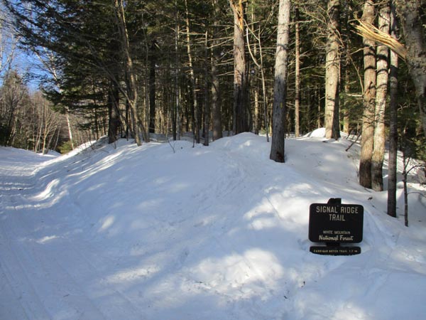
Signal Ridge Trail trailhead on Sawyer River Road
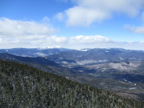
Looking at the Franconia Ridge and Mt. Bond from the Mt. Carrigain summit lookout tower
Directions to trailhead: Take Route 302 West from Bartlett to Sawyer River Road. In winter, there is a WMNF fee parking lot located to the left of the closed Sawyer River Road. The Signal Ridge Trail is 2 miles up Sawyer River Road, on the right.
Back to Mt. Carrigain Profile
|

