Home
States
Colorado
Connecticut
Maine
Massachusetts
New Hampshire
New York
Rhode Island
Utah
Vermont
View All
Lists
NE 4,000 Footers
NE 100 Highest
NH 4,000 Footers
NH 100 Highest
NH 52 With A View
NH Belknap Range
NH Ossipee 10
Links
Trail Conditions
Trip Log
Sunrises
Sunsets
About
|
Mt. Flume, Mt. Liberty
Lincoln, NH
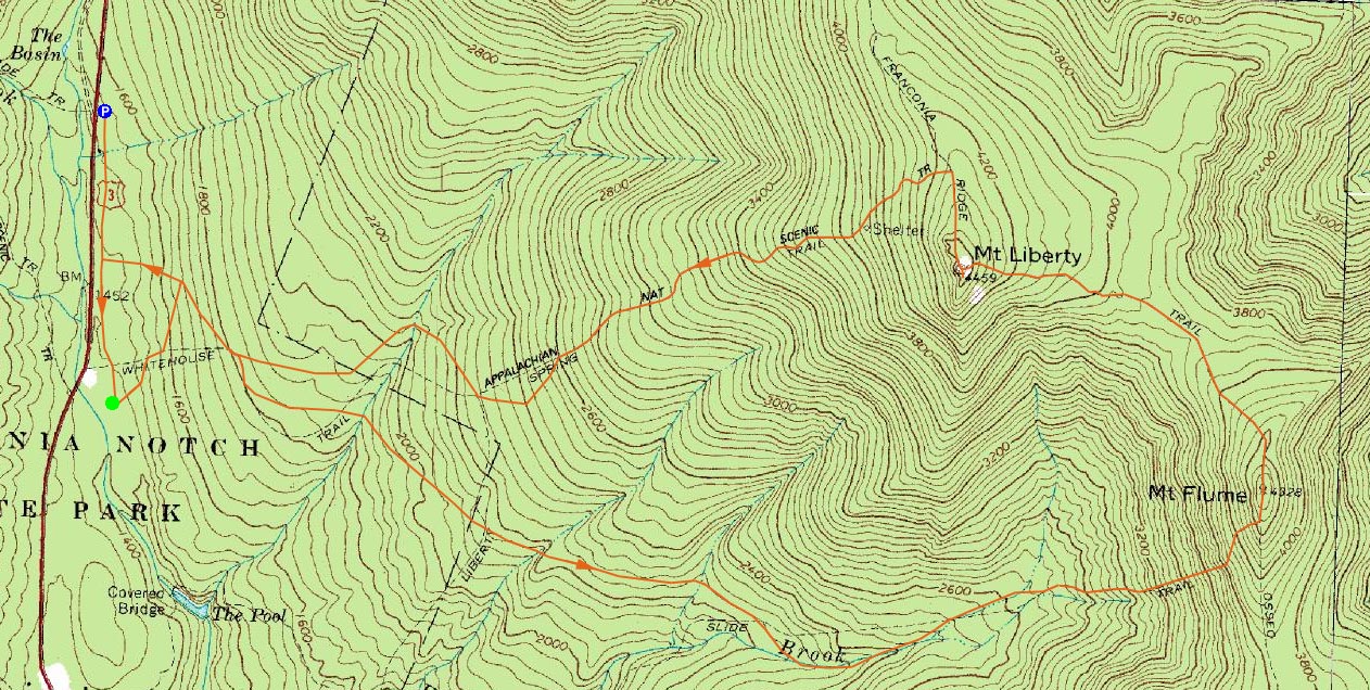
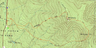
Trailheads, measurements, times, distances, and maps are all approximate and relative to the hike(s) as shown below.
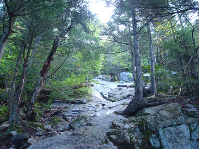
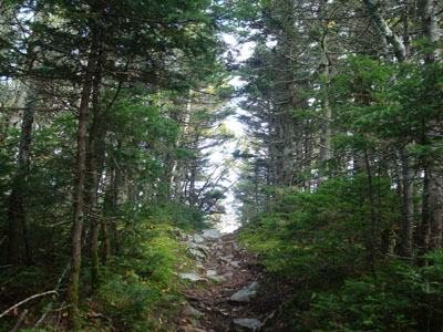
Looking up the Flume Slide Trail
Route: Bike path, Liberty Spring Trail, Flume Slide Trail, Franconia Ridge Trail, (Mt. Flume), Franconia Ridge Trail, (Mt. Liberty), Franconia Ridge Trail, Liberty Spring Trail, bushwhack, bike path
The night before this hike, I realized I would be hiking Mt. Liberty on the seventh anniversary of the terrorist attacks. What a great, subtle way give the finger to any terrorists who may somehow stumble upon this trip report - Liberty still lives in this country.
Parking at the Basin, I quickly set foot down the bike path, keeping my eyes open for the buskwhack route. Unfortunately, I forgot to look at my photo archive to see where I had would up. While I had a hunch at one point which would prove to be correct, I decided to just go to the Liberty Spring Trail head and do it the old fashioned way.
The Liberty Spring Trail from the bike path to the Flume Slide Trail junction is easy to moderate in pitch and overally pretty good going. The first part of the Flume Slide Trail was also very gradual, though there were quite a few ups and downs. Since I was making good time, I stopped to cut up some blowdowns on the way up.
After crossing a bunch of brooks and creeks, I finally reached the bottom of the slide. Unlike the Tripyramid and Owl's Head slides, most of this slide covered overhead with tree canopy. I found it to be similar to the first portion of the north slide on Mt. Tripyramid - mostly smooth rock slabs, some wet spots, and not much in way of views.
This seemed to go on forever, until I soon reached the top of the slide and followed the trail as it traversed the slope a bit, then made a steep ascent to the Franconia Ridge Trail. Soon thereafter, I was at the rocky summit area of Mt. Flume, enjoying decent, albeit cloudy in some directions, views.
After having a quick snack, I headed over to Liberty. This section of trail, though a bit steep coming off Flume and then approaching the top of Liberty, was mostly easy to moderate in pitch - for some reason I remembered it being a little bit steeper.
The views from Mt. Liberty were a bit stronger, as some clouds had moved out. I took a good twenty or so minute break here, enjoying the views and having another snack.
I didn't see a single person until I reached the Liberty Spring Trail - not bad for the Franconia Ridge!
Reaching the sharp turn toward the bottom of the Liberty Spring Trail, I hit the old logging road and then followed the herd path down to the creek. The water was a bit high, but I was able to find a relatively easy place to cross.
A nice, almost-fall hike.
| Hike Ratings |
|
Getting To Trailhead: |
Easy |
| Destination: |
Mt. Flume |
|
Length: |
Moderate |
|
Steepness: |
Very Difficult |
|
Navigation: |
Easy |
|
Views: |
Excellent |
|
Crowds: |
Minimal |
| Destination: |
Mt. Liberty |
|
Length: |
Moderate |
|
Steepness: |
Difficult |
|
Navigation: |
Easy |
|
Views: |
Excellent |
|
Crowds: |
Minimal |
|
| Hike Stats |
|
Date Hiked: |
Thursday, September 11, 2008 |
| Hike Commenced: |
8:05 AM |
| Parking Elevation: |
1,520' |
| Destination: |
Mt. Flume |
| Ascent Commenced: |
8:17 AM |
| Summit Reached: |
10:41 AM |
| Time Elapsed: |
02:24 |
| Trailhead Elevation: |
1,420' |
| Summit Elevation: |
4,328' |
| Vertical Gain: |
3,068' |
| Destination: |
Mt. Liberty |
| Ascent Commenced: |
10:49 AM |
| Summit Reached: |
11:28 AM |
| Time Elapsed: |
00:39 |
| Trailhead Elevation: |
4,328' |
| Summit Elevation: |
4,459' |
| Vertical Gain: |
609' |
|
|
| Hike Ended: |
1:32 PM |
| Hike Time Elapsed: |
05:15 |
| Hike Vertical Gain: |
3,797' |
|
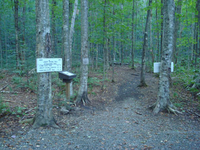
The Liberty Spring Trail trailhead
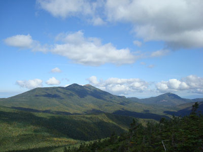
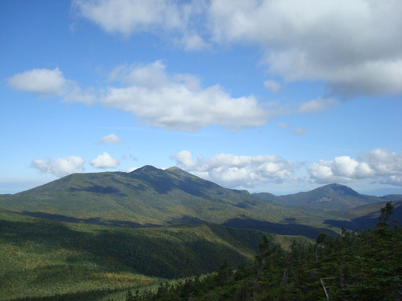
Looking at Mt. Lincoln, Mt. Lafayette, and Mt. Garfield from the Mt. Flume summit
The Franconia Ridge Trail between Mt. Flume and Mt. Liberty
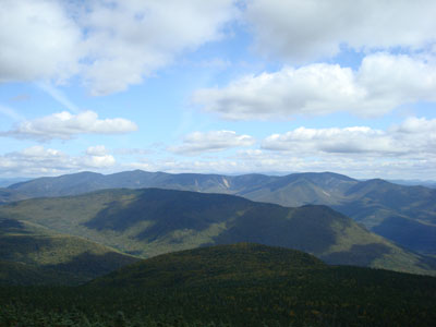
Looking over Owl's Head at the Twins and Bonds from the Mt. Liberty summit

Directions to trailhead: Take Interstate 93 north from Lincoln to the Basin. Walk south down the bike path - the Liberty Spring Trail will eventually be on the left.
Back to Mt. Flume Profile
Back to Mt. Liberty Profile
|