Home
States
Colorado
Connecticut
Maine
Massachusetts
New Hampshire
New York
Rhode Island
Utah
Vermont
View All
Lists
NE 4,000 Footers
NE 100 Highest
NH 4,000 Footers
NH 100 Highest
NH 52 With A View
NH Belknap Range
NH Ossipee 10
Links
Trail Conditions
Trip Log
Sunrises
Sunsets
About
|
Mt. Isolation
Jackson, NH, Sargents Purchase, NH, Cutts Grant, NH
Trailheads, measurements, times, distances, and maps are all approximate and relative to the hike(s) as shown below.
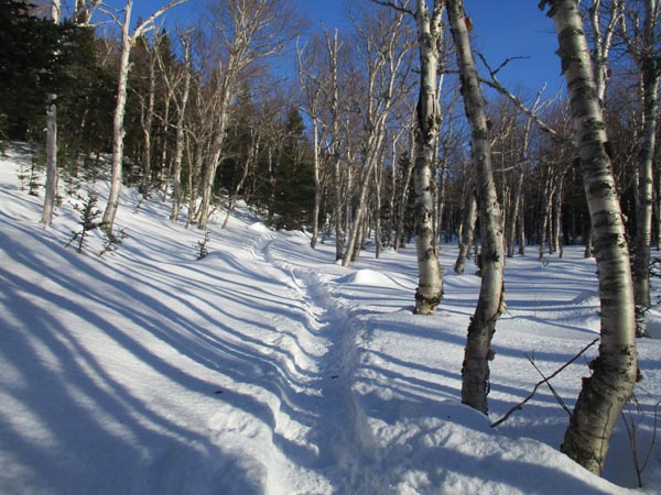
The Engine Hill bushwhack
Route: Rocky Branch Trail, (Engine Hill bushwhack), Isolation Trail, (bushwhack), Davis Path, Isolation Spur, (Mt. Isolation), Isolation Spur, Davis Path, (bushwhack), Isolation Trail, (Engine Hill bushwhack), Rocky Branch Trail
All others were booting today (earlier hikers left behind postholes, including some deep ones multiple feet down into mud and pooled water), but I found snowshoes to be the best option. In the very least, snowshoes need to be carried, as the snowpack is very deep and this route is off trail for awhile; a change in weather or conditions could strand a barebooter due to the depth.
Snowpack is initially 1-2 feet on Rocky Branch, with a few short open areas from perks. The snowpack is closer to 3-4 feet by the height of land. The height of land is a bit vexing, as the trail is pooled water, requiring some bushwhacking through hobblebush. Some deep postholes here.
The bushwhack through Engine Hill is...interesting. The initial route goes through multiple mudpits. Soon thereafter, there's a split...I have no clue where uphill (right) goes. Downhill (left) holds about 3,200 feet, with some diverging tracks around a mooseyard. Then, suddenly, it drops downhill 200 vertical feet to the trail. On the return trip, I tried to cut this off, but didn't care for the route. Not great bushwhacking today due to the softer snow. In prior winters, I tend to favor a higher elevation for this bushwhack to get away from the muck.
Isolation had some mucky areas around the brooks. Higher up, the packed route deviates from the trail near the ridge. Prior to the campsite, I took the short bushwhack avoiding that uphill; quick and to the point, but too soft to bareboot.
Davis Path had some blowdown resulting in a herd path or two; I cut these out and brushed in the herd path. The actual trail in those short stretches is obviously not packed for barebooting. Brushier than normal, as the snowpack has one up higher in the trees. Did note that a barebooter went in deep in one of the hidden mud pits today. The Isolation Spur is well filled in with snow.
Mild weather, snowpack, and partly sunny skies made it feel like March.
| Hike Ratings |
|
Getting To Trailhead: |
Easy |
| Destination: |
Mt. Isolation |
|
Length: |
Difficult |
|
Steepness: |
Difficult |
|
Navigation: |
Difficult |
|
Views: |
Excellent |
|
Crowds: |
Minimal |
|
| Hike Stats |
|
Date Hiked: |
Saturday, December 15, 2018 |
| Parking Elevation: |
1,260' |
| Destination: |
Mt. Isolation |
| Time Elapsed: |
03:13 |
| Trailhead Elevation: |
1,260' |
| Summit Elevation: |
4,004' |
| Vertical Gain: |
3,234' |
|
|
| Hike Time Elapsed: |
06:20 |
| Hike Vertical Gain: |
3,524' |
|
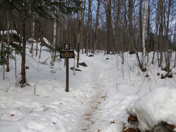
The Rocky Branch Trail trailhead
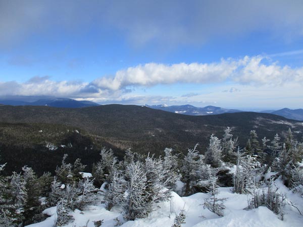
Looking at the Baldfaces from Mt. Isolation
Directions to trailhead: Take Route 16 North from the Route 302-16 junction in Glen. A few minutes having passing Jackson and just before 16 starts to climb to Pinkham Notch, the Rocky Branch parking lot will be on the left. The Rocky Branch Trail trailhead is at the north side of the parking lot.
Back to Mt. Isolation Profile
|

