Home
States
Colorado
Connecticut
Maine
Massachusetts
New Hampshire
New York
Rhode Island
Utah
Vermont
View All
Lists
NE 4,000 Footers
NE 100 Highest
NH 4,000 Footers
NH 100 Highest
NH 52 With A View
NH Belknap Range
NH Ossipee 10
Links
Trail Conditions
Trip Log
Sunrises
Sunsets
About
|
Mt. Klem
Gilford, NH
Trailheads, measurements, times, distances, and maps are all approximate and relative to the hike(s) as shown below.
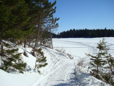
Looking at Round Pond from the Round Pond Trail
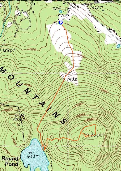
Route: Round Pond Trail, Red Trail, bushwack, (Mt. Klem), bushwack, Red Trail, Round Pond Trail
Today's shorter, somewhat easier hike in the don't-hurt-my-back-anymore project was Mt. Klem. Though I wanted to add in Rand Mountain or Mt. Mack, I didn't want to do anything to push my recovery in the wrong direction.
Arriving at the trailhead on Grant Road, I was happy to see a small parking area had been plowed.
The trail starts, without any sign or announcement, in a forest of No Trespassing signs - the first few hundred yards are just plastered with them on each side of it - in other words, I think the message is to stay on the trail.
Soon the Round Pond Trail enters some more open fields and offers some nice views of Belknap Mountain, Gunstock Mountain, and Mt. Rowe. Shortly after, the trail starts to ascend a bit and bears right - and quickly enters into the woods.
Not too long after, a snowmobile trail joins from the right. While the trail had been broken out up to this point, the sled traffic along with the easy to moderate grades made for undemanding snowshoeing.
Rather soon Round Pond came into view - what a neat place! I could see snowmobilers had been having fun with this big open area - I look forward to checking this out in the warmer months.
Once the Round Pond Trail dips down to near water level, the Red Trail to Mt. Klem departs to the left. Fortunately or not, it wasn't broken out.
The Red Trail is pretty easy to follow most of the way - red wooden diamonds are nailed to the trees at reasonable intervals. Not overly steep, the trail provides multiple decent view points along the way, both to the south and to the north.
West of the Mt. Klem summit I lost the trail - no sign of consistent old tracks (any of which would be probably two storms old) or wooden diamonds. After looking around a little, I set an easterly course through the sparsely wooded area, before aiming for high points. Sure enough, I found a little wooded area with a Mt. Klem sign.
Satisfied that I had found the summit, I continued east, occasionally following some ribbons in the trees, hoping to hit the Red Trail (and White Trail junction). Sure enough, I found it (unbroken of course). My next step was to try and follow the Red Trail back to where I had lost it.
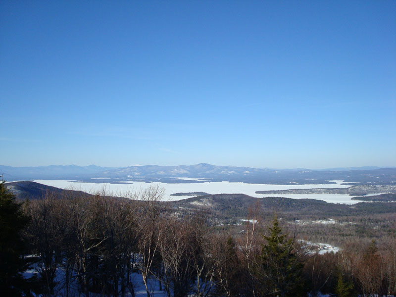
Along the way I came to the northern view point - wow! A large area has been cleared out, providing stunning views of the Sandwich Range (and beyond), Lake Winnipesaukee, the Ossipee Mountains, and into Maine. Along with the Round Pond area, this view point has cemented Mt. Klem as being my favorite peak in the Belknap Range thus far (having been to 9 of them). I ended up spending at least 5 minutes just taking in the view - I can see why some people have hidden little plagues in honor of loved pets on a tree here - it's a great place off the beaten path.
Speaking of unbeaten paths, I still had to find my way back. The Red Trail was well marked here, and continued to be until I came up near where I lost it - once again, it was hard to follow and there were no obvious markings - for probably a few hundred yards. Not a big deal, but in a somewhat sparsely vegetated area in the winter, this adds a bit of challenge. Hopefully the arrows I drew in the snow will help anyone who happens to venture this way before the next storm.
Back on the Round Pond Trail, I made a short detour onto Round Pond, as I really wanted to have a path line going over the pond in my trip report map - now I can brag about walking on water.
| Hike Ratings |
|
Getting To Trailhead: |
Easy |
| Destination: |
Mt. Klem |
|
Length: |
Moderate |
|
Steepness: |
Moderate |
|
Navigation: |
Moderate |
|
Views: |
Excellent |
|
Crowds: |
Minimal |
|
| Hike Stats |
|
Date Hiked: |
Sunday, February 24, 2008 |
| Hike Commenced: |
2:18 PM |
| Parking Elevation: |
1,200' |
| Destination: |
Mt. Klem |
| Ascent Commenced: |
2:19 PM |
| Summit Reached: |
3:16 PM |
| Time Elapsed: |
00:57 |
| Trailhead Elevation: |
1,205' |
| Summit Elevation: |
2,001' |
| Vertical Gain: |
896' |
|
|
| Hike Ended: |
4:27 PM |
| Hike Time Elapsed: |
02:09 |
| Hike Vertical Gain: |
1,041' |
|
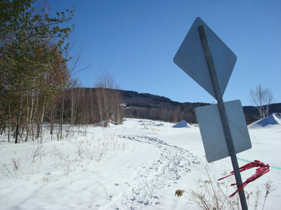
The Round Pond Trail trailhead off Grant Road
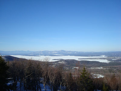
Looking north at the Ossipee Mountains (and behind them, Mt. Washington in white) from the viewpoint north of the Mt. Klem summit


Directions to trailhead: ---Please note, as of Fall 2008, this trailhead is reportedly closed to hikers.--- From Alton, take Route 11 West to Route 11A West. Take a left onto Grant Road - the small parking area and trailhead are on the left, just before the signs warning of road barriers, etc.
Back to Mt. Klem Profile
|