Home
States
Colorado
Connecticut
Maine
Massachusetts
New Hampshire
New York
Rhode Island
Utah
Vermont
View All
Lists
NE 4,000 Footers
NE 100 Highest
NH 4,000 Footers
NH 100 Highest
NH 52 With A View
NH Belknap Range
NH Ossipee 10
Links
Trail Conditions
Trip Log
Sunrises
Sunsets
About
|
Mt. Liberty
Lincoln, NH
Trailheads, measurements, times, distances, and maps are all approximate and relative to the hike(s) as shown below.
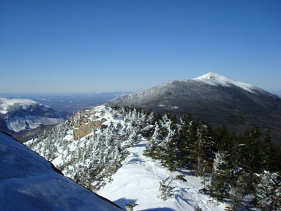
Looking down the Franconia Ridge Trail from near the Mt. Liberty summit
Route: Whitehouse Trail, Liberty Springs Trail, Franconia Ridge Trail, (Mt. Liberty), Franconia Ridge Trail, Liberty Springs Trail, Whitehouse Trail
With lousy weekend weather, I decided to ski both days. Seeing a nice forecast for Monday, I took a half day off at work and headed up to Franconia Notch.
Arriving after lunch time, I was surprised to see that I was the only person in the hikers' parking lot. As such, I was the first one to use the Whitehouse Trail, which was covered in about half an inch of snow.
After taking this somewhat flat, meandering trail to the snowmobile trail and then to the Liberty Springs Trail trailhead.
The Liberty Springs Trail isn't overly steep for much of the early portion. Passing the shortcut bushwack (which I ruled out using due to the conditions), I was surprised to see it had been broken out over the past weekend.
The brook crossings were a bit tricky, as the snowbridges were not stable (when present). After the largest brook crossing, the trail starts to steepen up a bit, becoming steady as it approaches the Liberty Springs camp site.
The Franconia Ridge Trail is rather gradual until reaching the base of the peak. I found the trail to be a bit tricky to follow, as the wind had drifted the powder of the trail in some places. Also, due to the snowdepths, the blazes weren't always obvious.
The top of the peak was a bit icy, however I was able to bareboot all the way without any traction devices.
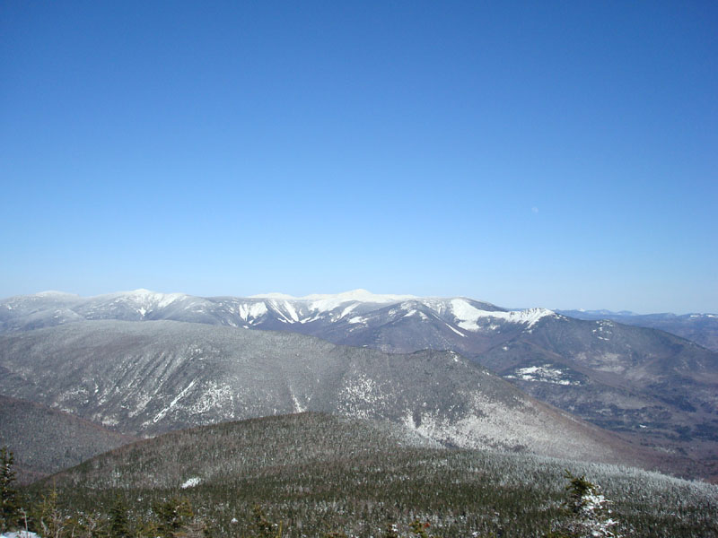
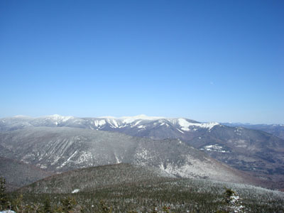
The views were amazing - even Mt. Washington was easily seen without any cloud cover.
While I had the energy to do so, I decided to skip going to Mt. Flume, as I was running out of daylight and I wanted to get out of the wind. After enjoying the views and a ham sandwich, I pulled out my ice axe and headed down.
The trip down was fairly uneventful - I was able to do some short slides on the steeper portions, but I was never able to any for a significant duration. I was surprised to pass a group of people who had hiked partway up - I figured no one would bother to start this hike so late in the day! They weren't well equipped and fortunately they had the sense to turn back.
All things considered, a nice day to be out on the trails.
| Hike Ratings |
|
Getting To Trailhead: |
Easy |
| Destination: |
Mt. Liberty |
|
Length: |
Moderate |
|
Steepness: |
Difficult |
|
Navigation: |
Moderate |
|
Views: |
Excellent |
|
Crowds: |
Minimal |
|
| Hike Stats |
|
Date Hiked: |
Monday, March 17, 2008 |
| Hike Commenced: |
12:43 PM |
| Parking Elevation: |
1,400' |
| Destination: |
Mt. Liberty |
| Ascent Commenced: |
12:44 PM |
| Summit Reached: |
3:24 PM |
| Time Elapsed: |
02:40 |
| Trailhead Elevation: |
1,400' |
| Summit Elevation: |
4,459' |
| Distance: |
4 miles |
| Vertical Gain: |
3,169' |
|
|
| Hike Ended: |
5:48 PM |
| Hike Time Elapsed: |
05:05 |
| Hike Distance: |
8 miles |
| Hike Vertical Gain: |
3,279' |
|
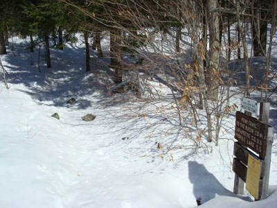
The Whitehouse Trail trailhead
Looking over Owl's Head and the Bonds at the Presidentials from the Mt. Liberty summit


Directions to trailhead: Take I-93 North to the Flume Visitor Center exit. Take a right at the end of the offramp, then take a right at the hiker parking lot. The Whitehouse Trail trailhead is at the back of the parking lot.
Back to Mt. Liberty Profile
|