Home
States
Colorado
Connecticut
Maine
Massachusetts
New Hampshire
New York
Rhode Island
Utah
Vermont
View All
Lists
NE 4,000 Footers
NE 100 Highest
NH 4,000 Footers
NH 100 Highest
NH 52 With A View
NH Belknap Range
NH Ossipee 10
Links
Trail Conditions
Trip Log
Sunrises
Sunsets
About
|
Mt. Pawtuckaway (Middle Peak), Mt. Pawtuckaway (South Peak)
Nottingham, NH
Trailheads, measurements, times, distances, and maps are all approximate and relative to the hike(s) as shown below.
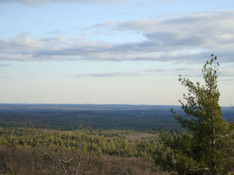
Looking down the southern shoulder of the Middle Peak of Mt. Pawtuckaway
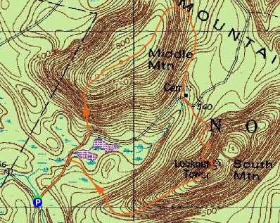
Route: Tower Road, bushwhack, (Mt. Pawtuckaway - Middle Peak), various roads/trails, (Mt. Pawtuckaway - South Peak), various roads/trails/bushwhack, Tower Road
Sick of the spring snow and monorails up north, it was time to head south for some hiking. Thus, it was time for my first trip to Pawtuckaway State Park.
Starting at the gate on Reservation Road, we hiked up Tower Road a bit, before bushwhacking pretty much straight up Middle Peak. While there weren't any strong views at the highpoint, there were nonetheless some great views from the southern ledges of the peak.
After reaching the highpoint, we headed down the Middle Mountain Trail. Devastated by the ice storm and subsequent logging, we were constantly stepping over blowdowns. Reaching an old set of foundations, we turned and ascended up the somewhat steep trail to the south peak.
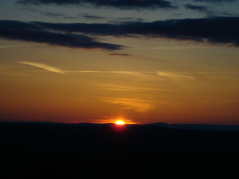
While there were good views from the ledges of the south peak, the views from the fire tower were tremendous - Wachusett, the Belknaps, Newington, Monadnock - all sorts of things were visible. The sunset was quite good too, with lots of oranges and reds.
For the descent, we headed down another trail, before likely losing it due to blowdowns. We ended up bushwhacking back to the trail, then followed it to Tower Road and back to where we parked.
A nice set of peaks in a beautiful park that deserves revisiting!
| Hike Ratings |
|
Getting To Trailhead: |
Easy |
| Destination: |
Mt. Pawtuckaway (Middle Peak) |
|
Length: |
Easy |
|
Steepness: |
Difficult |
|
Navigation: |
Difficult |
|
Views: |
Excellent |
|
Crowds: |
Minimal |
| Destination: |
Mt. Pawtuckaway (South Peak) |
|
Length: |
Moderate |
|
Steepness: |
Difficult |
|
Navigation: |
Easy |
|
Views: |
Excellent |
|
Crowds: |
Minimal |
|
| Hike Stats |
|
Date Hiked: |
Tuesday, March 31, 2009 |
| Hike Commenced: |
5:31 PM |
| Parking Elevation: |
450' |
| Destination: |
Mt. Pawtuckaway (Middle Peak) |
| Ascent Commenced: |
5:31 PM |
| Summit Reached: |
6:02 PM |
| Time Elapsed: |
00:31 |
| Trailhead Elevation: |
450' |
| Summit Elevation: |
840' |
| Vertical Gain: |
400' |
| Destination: |
Mt. Pawtuckaway (South Peak) |
| Ascent Commenced: |
6:02 PM |
| Summit Reached: |
6:44 PM |
| Time Elapsed: |
00:42 |
| Trailhead Elevation: |
840' |
| Summit Elevation: |
908' |
| Vertical Gain: |
388' |
|
|
| Hike Ended: |
8:02 PM |
| Hike Time Elapsed: |
02:31 |
| Hike Vertical Gain: |
818' |
|
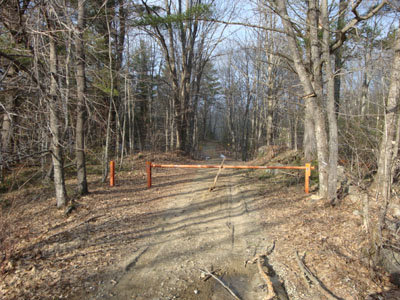
The Tower Road trailhead on Reservation Road

Looking south from the Middle Peak of Mt. Pawtuckaway
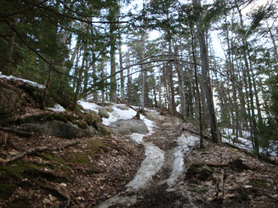
The trail to the South Peak of Mt. Pawtuckaway

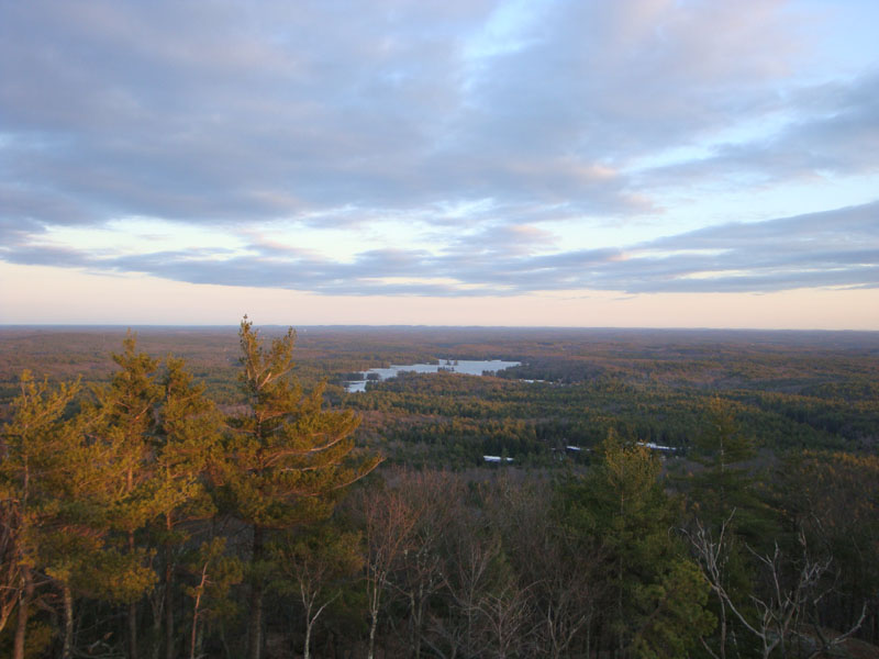
Pawtuckaway Pond as seen from the fire tower on South Peak of Mt. Pawtuckaway

The sunset as seen from the fire tower on the South Peak of Mt. Pawtuckaway

Directions to trailhead: Take Route 107 South from Deerfield Center. Reservation Road will eventually be on the left. Follow this dirt road, bearing right to avoid Tandy Road. The gated Tower Road will be on the left, on a sharp right turn. There is minimal room for roadside parking.
Back to Mt. Pawtuckaway (Middle Peak) Profile
Back to Mt. Pawtuckaway (South Peak) Profile
|