Home
States
Colorado
Connecticut
Maine
Massachusetts
New Hampshire
New York
Rhode Island
Utah
Vermont
View All
Lists
NE 4,000 Footers
NE 100 Highest
NH 4,000 Footers
NH 100 Highest
NH 52 With A View
NH Belknap Range
NH Ossipee 10
Links
Trail Conditions
Trip Log
Sunrises
Sunsets
About
|
Oak Hill
Loudon, NH
Trailheads, measurements, times, distances, and maps are all approximate and relative to the hike(s) as shown below.
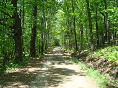
Looking up the road to Oak Hill
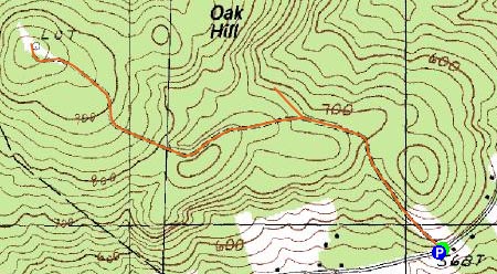
Route: Oak Hill Summit Road, Unknown trail, Oak Hill Summit Road, (Oak Hill), Oak Hill Summit Road
After hiking the Uncanoonucs, my final hike of the day was Oak Hill.
Arriving at the beginning of the road, there were already a few vehicles lining Oak Hill Road. The road to the fire tower is signed (note that the mileage on the sign is roundtrip, not one way) and the road is mostly flat. At one point, there was a fork in the road, with a quasi-snowmobile path going to the right. Thinking perhaps this was a faster, more direct way (since it was going uphill), and not having a map, I decided to give it a try. No dice.
Back on the road, I reached the summit fairly quickly. The summit area features no views and a variety of random stuff. The views from the firetower were strong, especially from inside the cab.
| Hike Ratings |
|
Getting To Trailhead: |
Easy |
| Destination: |
Oak Hill |
|
Length: |
Easy |
|
Steepness: |
Easy |
|
Navigation: |
Easy |
|
Views: |
Excellent |
|
Crowds: |
Heavy |
|
| Hike Stats |
|
Date Hiked: |
Sunday, June 1, 2008 |
| Hike Commenced: |
12:53 PM |
| Parking Elevation: |
558' |
| Destination: |
Oak Hill |
| Ascent Commenced: |
12:53 PM |
| Summit Reached: |
1:23 PM |
| Time Elapsed: |
00:30 |
| Trailhead Elevation: |
568' |
| Summit Elevation: |
990' |
| Vertical Gain: |
462' |
|
|
| Hike Ended: |
1:59 PM |
| Hike Time Elapsed: |
01:06 |
| Hike Vertical Gain: |
482' |
|
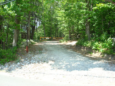
The trailhead on Oak Hill Road
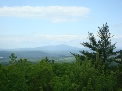
Looking at Kearsarge Mountain from the Oak Hill fire tower


Directions to trailhead: From I-93 North in Concord, take Exit 16, taking a right off the ramp. At the subsequent junction, go straight onto Shawmut Street, which becomes Oak Hill Road. The gated Oak Hill Summit Road will eventually be on the left side of the road, with some room to park on the right shoulder of the road.
Back to Oak Hill Profile
|