Home
States
Colorado
Connecticut
Maine
Massachusetts
New Hampshire
New York
Rhode Island
Utah
Vermont
View All
Lists
NE 4,000 Footers
NE 100 Highest
NH 4,000 Footers
NH 100 Highest
NH 52 With A View
NH Belknap Range
NH Ossipee 10
Links
Trail Conditions
Trip Log
Sunrises
Sunsets
About
|
South Moat Mountain
Albany, NH
Trailheads, measurements, times, distances, and maps are all approximate and relative to the hike(s) as shown below.
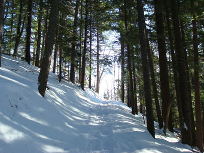
Looking up the lower portion of the Moat Mountain Trail
Route: Moat Mountain Trail
With only a few hours before clouds were supposed to move in, I decided to do a somewhat local hike. South Moat Mountain had been bittersweet for me, as it was where my knee first really started bothering me in the spring. Nonetheless, the summit views and somewhat nearby location brought me back.
After checking the trail to see what I needed to wear (ie, had it been barebooted), I put on my snowshoes and headed out. Though there was upwards of 6" of fresh powder, previous snowshoers had packed it down, making for pretty easy going.
The first portions of the trail are moderate at best - things steepen up at the first set of ledges. As was the case in the spring, the trail markings weren't the best in the world - resulting in split tracks in many places that were lacking blazes.
As I continued to ascend, I passed the snowshoers, resulting in me having to pack down the trail. Not long after, I passed the barebooters, resulting in me having to break out the trail. Up high the powder was upwards of 2 feet deep, resulting in me having to expend more effort than the first portion of the hike. It was worth it, however, as I was the first person at the awesome rocky summit area.
Though there were some clouds to the south, the views were spectacular - the Presidentials were out of the clouds and pretty much all of the peaks in all directions had a nice white coating on their trees and ledges.
After spending a decent amount of time on the summit taking in the views and chatting with the arriving snowshoers, I decided to bareboot the descent - the trail was packed well enough to do this at this point. I made great time on the steeps, as it was basically alpine skiing in boots - fun!
| Hike Ratings |
|
Getting To Trailhead: |
Easy |
| Destination: |
South Moat Mountain |
|
Length: |
Moderate |
|
Steepness: |
Difficult |
|
Navigation: |
Moderate |
|
Views: |
Excellent |
|
Crowds: |
Minimal |
|
| Hike Stats |
|
Date Hiked: |
Saturday, December 15, 2007 |
| Hike Commenced: |
9:24 AM |
| Parking Elevation: |
650' |
| Destination: |
South Moat Mountain |
| Ascent Commenced: |
9:24 AM |
| Summit Reached: |
11:08 AM |
| Time Elapsed: |
01:44 |
| Trailhead Elevation: |
650' |
| Summit Elevation: |
2,770' |
| Distance: |
2.7 miles |
| Vertical Gain: |
2,235' |
|
|
| Hike Ended: |
12:46 PM |
| Hike Time Elapsed: |
03:02 |
| Hike Distance: |
5.4 miles |
| Hike Vertical Gain: |
2,350' |
|
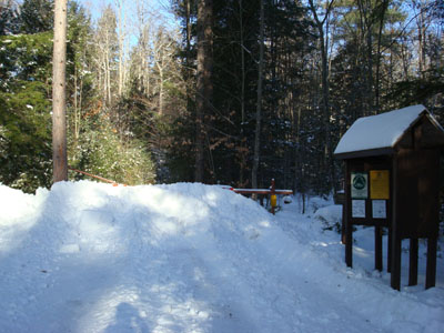
Moat Mountain Trail trailhead
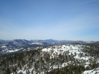
Looking northwest from the South Moat Mountain summit toward Mt. Carrigain
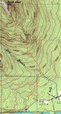

Directions to trailhead: Take Route 16 North into Conway. Take a left at the first set of downtown lights onto West Side Road. Soon after, take a left onto Passaconaway Road. A few minutes down the road, the Moat Mountain Trail trailhead and WMNF fee parking area will be on the right. If you pass the picnic area on your left, you've gone just a little bit too far.
Back to South Moat Mountain Profile
|