Home
States
Colorado
Connecticut
Maine
Massachusetts
New Hampshire
New York
Rhode Island
Utah
Vermont
View All
Lists
NE 4,000 Footers
NE 100 Highest
NH 4,000 Footers
NH 100 Highest
NH 52 With A View
NH Belknap Range
NH Ossipee 10
Links
Trail Conditions
Trip Log
Sunrises
Sunsets
About
|
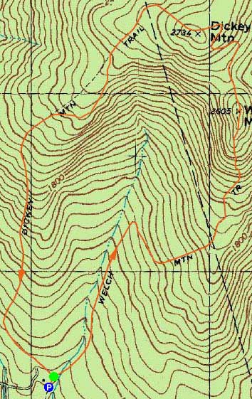
Welch Mountain, Dickey Mountain
Thornton, NH, Waterville Valley, NH
Trailheads, measurements, times, distances, and maps are all approximate and relative to the hike(s) as shown below.
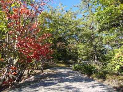
Heading up the Welch-Dickey Loop Trail to Welch Mountain
Route: Welch-Dickey Loop Trail, (Welch Mountain), Welch-Dickey Loop Trail, (Dickey Mountain), Welch-Dickey Loop Trail
With a nice, warm afternoon, I headed over to Welch-Dickey.
After jogging the brief flats down low, I took a hiking pace up to the first ledges on Welch, where there were excellent views. Working my way up the scrambles to the summit, there were some nice early fall colors in places.
After taking in the excellent views from Welch Mountain, I continued over to Dickey Mountain. Though tempted to check out the view spur trail, I opted to keep on moving and get out before dark, jogging the last bit of the trail back to the parking lot.
| Hike Ratings |
|
Getting To Trailhead: |
Easy |
| Destination: |
Welch Mountain |
|
Length: |
Moderate |
|
Steepness: |
Difficult |
|
Navigation: |
Easy |
|
Views: |
Excellent |
|
Crowds: |
Minimal |
| Destination: |
Dickey Mountain |
|
Length: |
Moderate |
|
Steepness: |
Difficult |
|
Navigation: |
Easy |
|
Views: |
Excellent |
|
Crowds: |
Minimal |
|
| Hike Stats |
|
Date Hiked: |
Monday, September 20, 2010 |
| Hike Commenced: |
4:19 PM |
| Parking Elevation: |
1,080' |
| Destination: |
Welch Mountain |
| Ascent Commenced: |
4:19 PM |
| Summit Reached: |
5:07 PM |
| Time Elapsed: |
00:48 |
| Trailhead Elevation: |
1,090' |
| Summit Elevation: |
2,605' |
| Distance: |
2 miles |
| Vertical Gain: |
1,545' |
| Destination: |
Dickey Mountain |
| Ascent Commenced: |
5:12 PM |
| Summit Reached: |
5:26 PM |
| Time Elapsed: |
00:14 |
| Trailhead Elevation: |
2,600' |
| Summit Elevation: |
2,734' |
| Distance: |
.5 mile |
| Vertical Gain: |
314' |
|
|
| Hike Ended: |
6:10 PM |
| Hike Time Elapsed: |
01:51 |
| Hike Distance: |
4.5 miles |
| Hike Vertical Gain: |
1,899' |
|
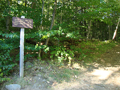
The Welch-Dickey Loop Trail trailhead
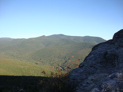
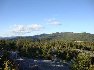
Looking at Sandwich Mountain from near the Welch Mountain summit
Looking down the Welch-Dickey Loop Trail at Welch Mountain on the way to Dickey Mountain
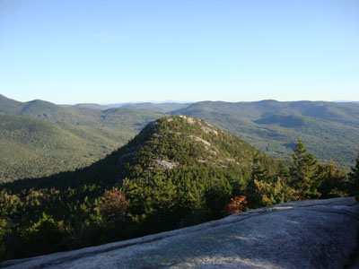
Looking at Mt. Tecumseh from near the Dickey Mountain summit

Directions to trailhead: Take Route 49 to Six Mile Bridge - take a left there and go up the hill. Take a right onto Orris Road. National Forest pay parking lot will be on the right after a short drive.
Back to Welch Mountain Profile
Back to Dickey Mountain Profile
|


