Home
States
Colorado
Connecticut
Maine
Massachusetts
New Hampshire
New York
Rhode Island
Utah
Vermont
View All
Lists
NE 4,000 Footers
NE 100 Highest
NH 4,000 Footers
NH 100 Highest
NH 52 With A View
NH Belknap Range
NH Ossipee 10
Links
Trail Conditions
Trip Log
Sunrises
Sunsets
About
|
West Rattlesnake
Holderness, NH
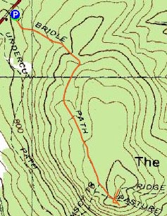
Trailheads, measurements, times, distances, and maps are all approximate and relative to the hike(s) as shown below.
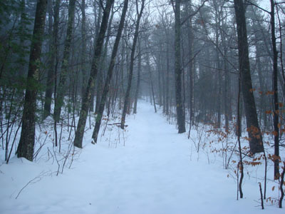
Looking up the Old Bridle Path
Route: Old Bridle Path
After some snow and rain, the satellite imagery showed the clouds moving out. Though it looked like there was a good chance the fog wouldn't lift in time for the sunset, I decided to head out for a short hike anyways, as I suspected that, in the event the fog lifted in time, and that I finished this rediculous run-on sentence, the sunset display would be great.
I was pleased to see the new parking area was complete - it was under construction the last time I was in the area. Larger than the Mt. Morgan lot, the entrance provides a better look up and down 113, whereas the Mt. Morgan parking lot has a blindspot looking east. At the back of the parking lot is a new trailhead for the Old Bridle Path, thus cutting off a few vertical feet.
Surprisingly, no one had been up the Old Bridle Path today. In previous experiences, the trail has been broken out almost instantly after weather events.
While I could see signs of clearing as I had driven to the trailhead, it was clear (figuratively, not literally) that there was still plenty of fog in the area. After reaching the highpoint, I headed back to the ledges and waited.
Though there was a limited view of the eastern shores of Squam Lake, there wasn't much else to see. I waited for a bit, but then gave up like the French and headed back down. As I neared the parking lot, I could see the fog had lifted from much of the Squam Range, but not from the lake. Had there been another 30 minutes of sunlight, I suspect the sunset would have been spectacular.
| Hike Ratings |
|
Getting To Trailhead: |
Easy |
| Destination: |
West Rattlesnake |
|
Length: |
Easy |
|
Steepness: |
Easy |
|
Navigation: |
Easy |
|
Views: |
Moderate (due to weather) |
|
Crowds: |
Minimal |
|
| Hike Stats |
|
Date Hiked: |
Monday, December 1, 2008 |
| Hike Commenced: |
3:34 PM |
| Parking Elevation: |
815' |
| Destination: |
West Rattlesnake |
| Ascent Commenced: |
3:35 PM |
| Summit Reached: |
3:56 PM |
| Time Elapsed: |
00:21 |
| Trailhead Elevation: |
815' |
| Summit Elevation: |
1,240' |
| Distance: |
.9 miles |
| Vertical Gain: |
440' |
|
|
| Hike Ended: |
4:39 PM |
| Hike Time Elapsed: |
01:05 |
| Hike Distance: |
1.8 miles |
| Hike Vertical Gain: |
455' |
|
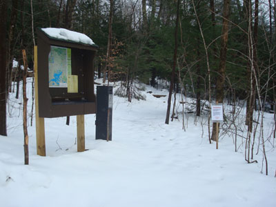
The Old Bridle Path trailhead at the back of the new parking area
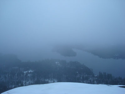
Looking at Squam Lake from West Rattlesnake

Directions to trailhead: Take Route 113 West from Center Sandwich. The new (2008) West Rattlesnake parking lot is on the left at a height of land, across from the Mt. Morgan parking area. The Old Bridle Path trailhead is located at the back of the new parking lot.
Back to West Rattlesnake Profile
|

